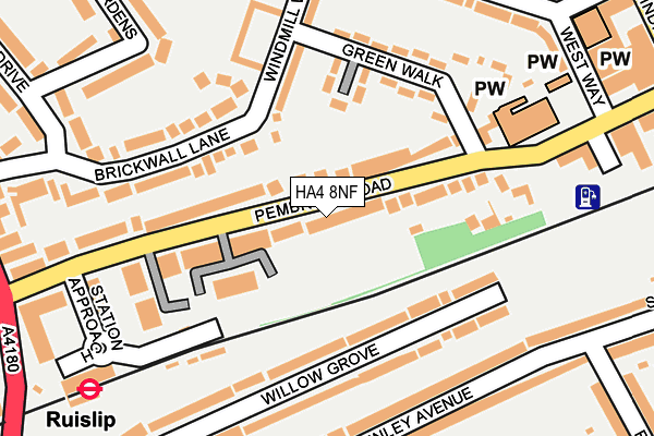
HA4 8NF lies on Pembroke Road in Ruislip. HA4 8NF is located in the Ruislip Manor electoral ward, within the London borough of Hillingdon and the English Parliamentary constituency of Uxbridge and South Ruislip. The Sub Integrated Care Board (ICB) Location is NHS North West London ICB - W2U3Z and the police force is Metropolitan Police. This postcode has been in use since January 1980.


GetTheData
Source: OS OpenMap – Local (Ordnance Survey)
Source: OS VectorMap District (Ordnance Survey)
Licence: Open Government Licence (requires attribution)
| Easting | 509721 |
| Northing | 187173 |
| Latitude | 51.572758 |
| Longitude | -0.418169 |
GetTheData
Source: Open Postcode Geo
Licence: Open Government Licence
| Street | Pembroke Road |
| Town/City | Ruislip |
| Country | England |
| Postcode District | HA4 |
➜ See where HA4 is on a map ➜ Where is Ruislip? | |
GetTheData
Source: Land Registry Price Paid Data
Licence: Open Government Licence
Elevation or altitude of HA4 8NF as distance above sea level:
| Metres | Feet | |
|---|---|---|
| Elevation | 50m | 164ft |
Elevation is measured from the approximate centre of the postcode, to the nearest point on an OS contour line from OS Terrain 50, which has contour spacing of ten vertical metres.
➜ How high above sea level am I? Find the elevation of your current position using your device's GPS.
GetTheData
Source: Open Postcode Elevation
Licence: Open Government Licence
| Ward | Ruislip Manor |
| Constituency | Uxbridge And South Ruislip |
GetTheData
Source: ONS Postcode Database
Licence: Open Government Licence
56, PEMBROKE ROAD, RUISLIP, HA4 8NF 2002 4 JUL £350,000 |
56, PEMBROKE ROAD, RUISLIP, HA4 8NF 2000 1 JUN £250,000 |
GetTheData
Source: HM Land Registry Price Paid Data
Licence: Contains HM Land Registry data © Crown copyright and database right 2025. This data is licensed under the Open Government Licence v3.0.
| Ruislip | Ruislip | 228m |
| Ruislip (Ruislip Station Approach) | Ruislip | 232m |
| Ruislip (Ruislip Station Approach) | Ruislip | 234m |
| Ruislip (Ruislip Station Approach) | Ruislip | 245m |
| Ruislip (Ruislip Station Approach) | Ruislip | 246m |
| Ruislip Underground Station | Ruislip | 302m |
| Ruislip Manor Underground Station | Ruislip Manor | 363m |
| West Ruislip Underground Station | West Ruislip | 1,409m |
| Ruislip Gardens Underground Station | Ruislip Gardens | 1,434m |
| Eastcote Underground Station | Eastcote | 1,500m |
| West Ruislip Station | 1.4km |
| South Ruislip Station | 2.2km |
| Northolt Park Station | 4.4km |
GetTheData
Source: NaPTAN
Licence: Open Government Licence
GetTheData
Source: ONS Postcode Database
Licence: Open Government Licence


➜ Get more ratings from the Food Standards Agency
GetTheData
Source: Food Standards Agency
Licence: FSA terms & conditions
| Last Collection | |||
|---|---|---|---|
| Location | Mon-Fri | Sat | Distance |
| Times House | 18:30 | 13:00 | 279m |
| Shenley Avenue | 16:45 | 12:45 | 340m |
| Ruislip Delivery Office | 19:00 | 12:45 | 366m |
GetTheData
Source: Dracos
Licence: Creative Commons Attribution-ShareAlike
The below table lists the International Territorial Level (ITL) codes (formerly Nomenclature of Territorial Units for Statistics (NUTS) codes) and Local Administrative Units (LAU) codes for HA4 8NF:
| ITL 1 Code | Name |
|---|---|
| TLI | London |
| ITL 2 Code | Name |
| TLI7 | Outer London - West and North West |
| ITL 3 Code | Name |
| TLI74 | Harrow and Hillingdon |
| LAU 1 Code | Name |
| E09000017 | Hillingdon |
GetTheData
Source: ONS Postcode Directory
Licence: Open Government Licence
The below table lists the Census Output Area (OA), Lower Layer Super Output Area (LSOA), and Middle Layer Super Output Area (MSOA) for HA4 8NF:
| Code | Name | |
|---|---|---|
| OA | E00012285 | |
| LSOA | E01002470 | Hillingdon 007D |
| MSOA | E02000500 | Hillingdon 007 |
GetTheData
Source: ONS Postcode Directory
Licence: Open Government Licence
| HA4 8NE | Pembroke Road | 62m |
| HA4 8FB | Pembroke Road | 73m |
| HA4 8EW | Pembroke Road | 103m |
| HA4 8BT | Pembroke Road | 122m |
| HA4 6DG | Willow Grove | 126m |
| HA4 6DF | Willow Grove | 154m |
| HA4 8PP | Pembroke Road | 155m |
| HA4 8JS | Brickwall Lane | 164m |
| HA4 8NQ | Pembroke Road | 165m |
| HA4 8ND | Pembroke Road | 174m |
GetTheData
Source: Open Postcode Geo; Land Registry Price Paid Data
Licence: Open Government Licence