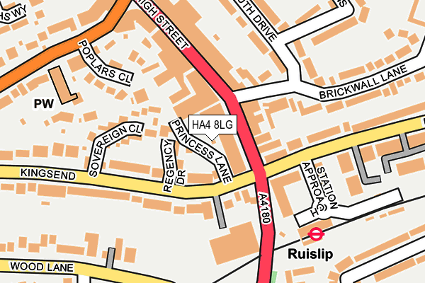
HA4 8LG is located in the Ruislip electoral ward, within the London borough of Hillingdon and the English Parliamentary constituency of Ruislip, Northwood and Pinner. The Sub Integrated Care Board (ICB) Location is NHS North West London ICB - W2U3Z and the police force is Metropolitan Police. This postcode has been in use since July 1990.


GetTheData
Source: OS OpenMap – Local (Ordnance Survey)
Source: OS VectorMap District (Ordnance Survey)
Licence: Open Government Licence (requires attribution)
| Easting | 509357 |
| Northing | 187147 |
| Latitude | 51.572595 |
| Longitude | -0.423428 |
GetTheData
Source: Open Postcode Geo
Licence: Open Government Licence
| Country | England |
| Postcode District | HA4 |
➜ See where HA4 is on a map ➜ Where is Ruislip? | |
GetTheData
Source: Land Registry Price Paid Data
Licence: Open Government Licence
Elevation or altitude of HA4 8LG as distance above sea level:
| Metres | Feet | |
|---|---|---|
| Elevation | 50m | 164ft |
Elevation is measured from the approximate centre of the postcode, to the nearest point on an OS contour line from OS Terrain 50, which has contour spacing of ten vertical metres.
➜ How high above sea level am I? Find the elevation of your current position using your device's GPS.
GetTheData
Source: Open Postcode Elevation
Licence: Open Government Licence
| Ward | Ruislip |
| Constituency | Ruislip, Northwood And Pinner |
GetTheData
Source: ONS Postcode Database
Licence: Open Government Licence
| Brickwall Lane | Ruislip | 39m |
| Brickwall Lane | Ruislip | 55m |
| Ruislip (Ruislip Station Approach) | Ruislip | 132m |
| Ruislip | Ruislip | 144m |
| Ruislip (Ruislip Station Approach) | Ruislip | 148m |
| Ruislip Underground Station | Ruislip | 174m |
| Ruislip Manor Underground Station | Ruislip Manor | 728m |
| West Ruislip Underground Station | West Ruislip | 1,053m |
| Ruislip Gardens Underground Station | Ruislip Gardens | 1,587m |
| Ickenham Underground Station | Ickenham | 1,746m |
| West Ruislip Station | 1km |
| South Ruislip Station | 2.4km |
| Northolt Park Station | 4.7km |
GetTheData
Source: NaPTAN
Licence: Open Government Licence
| Percentage of properties with Next Generation Access | 100.0% |
| Percentage of properties with Superfast Broadband | 100.0% |
| Percentage of properties with Ultrafast Broadband | 0.0% |
| Percentage of properties with Full Fibre Broadband | 0.0% |
Superfast Broadband is between 30Mbps and 300Mbps
Ultrafast Broadband is > 300Mbps
| Percentage of properties unable to receive 2Mbps | 0.0% |
| Percentage of properties unable to receive 5Mbps | 0.0% |
| Percentage of properties unable to receive 10Mbps | 0.0% |
| Percentage of properties unable to receive 30Mbps | 0.0% |
GetTheData
Source: Ofcom
Licence: Ofcom Terms of Use (requires attribution)
GetTheData
Source: ONS Postcode Database
Licence: Open Government Licence


➜ Get more ratings from the Food Standards Agency
GetTheData
Source: Food Standards Agency
Licence: FSA terms & conditions
| Last Collection | |||
|---|---|---|---|
| Location | Mon-Fri | Sat | Distance |
| Times House | 18:30 | 13:00 | 116m |
| Shenley Avenue | 16:45 | 12:45 | 348m |
| Sharps Lane | 18:15 | 13:00 | 415m |
GetTheData
Source: Dracos
Licence: Creative Commons Attribution-ShareAlike
The below table lists the International Territorial Level (ITL) codes (formerly Nomenclature of Territorial Units for Statistics (NUTS) codes) and Local Administrative Units (LAU) codes for HA4 8LG:
| ITL 1 Code | Name |
|---|---|
| TLI | London |
| ITL 2 Code | Name |
| TLI7 | Outer London - West and North West |
| ITL 3 Code | Name |
| TLI74 | Harrow and Hillingdon |
| LAU 1 Code | Name |
| E09000017 | Hillingdon |
GetTheData
Source: ONS Postcode Directory
Licence: Open Government Licence
The below table lists the Census Output Area (OA), Lower Layer Super Output Area (LSOA), and Middle Layer Super Output Area (MSOA) for HA4 8LG:
| Code | Name | |
|---|---|---|
| OA | E00012637 | |
| LSOA | E01002535 | Hillingdon 007E |
| MSOA | E02000500 | Hillingdon 007 |
GetTheData
Source: ONS Postcode Directory
Licence: Open Government Licence
| HA4 8LJ | High Street | 23m |
| HA4 7EB | Regency Drive | 55m |
| HA4 7EE | Regency Drive | 62m |
| HA4 8JY | High Street | 62m |
| HA4 7ED | Regency Drive | 71m |
| HA4 8JN | High Street | 104m |
| HA4 8NH | Pembroke Road | 115m |
| HA4 8NJ | Pembroke Road | 115m |
| HA4 8JR | Brickwall Lane | 116m |
| HA4 7EF | Sovereign Close | 130m |
GetTheData
Source: Open Postcode Geo; Land Registry Price Paid Data
Licence: Open Government Licence