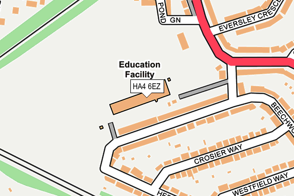
HA4 6EZ is located in the Ruislip Manor electoral ward, within the London borough of Hillingdon and the English Parliamentary constituency of Uxbridge and South Ruislip. The Sub Integrated Care Board (ICB) Location is NHS North West London ICB - W2U3Z and the police force is Metropolitan Police. This postcode has been in use since January 1980.


GetTheData
Source: OS OpenMap – Local (Ordnance Survey)
Source: OS VectorMap District (Ordnance Survey)
Licence: Open Government Licence (requires attribution)
| Easting | 509289 |
| Northing | 186608 |
| Latitude | 51.567764 |
| Longitude | -0.424576 |
GetTheData
Source: Open Postcode Geo
Licence: Open Government Licence
| Country | England |
| Postcode District | HA4 |
➜ See where HA4 is on a map ➜ Where is Ruislip? | |
GetTheData
Source: Land Registry Price Paid Data
Licence: Open Government Licence
Elevation or altitude of HA4 6EZ as distance above sea level:
| Metres | Feet | |
|---|---|---|
| Elevation | 50m | 164ft |
Elevation is measured from the approximate centre of the postcode, to the nearest point on an OS contour line from OS Terrain 50, which has contour spacing of ten vertical metres.
➜ How high above sea level am I? Find the elevation of your current position using your device's GPS.
GetTheData
Source: Open Postcode Elevation
Licence: Open Government Licence
| Ward | Ruislip Manor |
| Constituency | Uxbridge And South Ruislip |
GetTheData
Source: ONS Postcode Database
Licence: Open Government Licence
| Ruislip Rugby Football Club (West End Road) | Ruislip | 163m |
| Grosvenor Vale | Ruislip | 247m |
| Grosvenor Vale | Ruislip | 357m |
| Chichester Avenue | Ruislip | 360m |
| Chichester Avenue | Ruislip | 388m |
| Ruislip Underground Station | Ruislip | 440m |
| West Ruislip Underground Station | West Ruislip | 947m |
| Ruislip Manor Underground Station | Ruislip Manor | 1,006m |
| Ruislip Gardens Underground Station | Ruislip Gardens | 1,239m |
| Ickenham Underground Station | Ickenham | 1,368m |
| West Ruislip Station | 0.9km |
| South Ruislip Station | 2.1km |
| Northolt Park Station | 4.7km |
GetTheData
Source: NaPTAN
Licence: Open Government Licence
GetTheData
Source: ONS Postcode Database
Licence: Open Government Licence


➜ Get more ratings from the Food Standards Agency
GetTheData
Source: Food Standards Agency
Licence: FSA terms & conditions
| Last Collection | |||
|---|---|---|---|
| Location | Mon-Fri | Sat | Distance |
| Crosier Way | 16:45 | 12:00 | 277m |
| Grosvenor Vale | 16:45 | 12:45 | 315m |
| Roxburn Way | 16:45 | 12:00 | 378m |
GetTheData
Source: Dracos
Licence: Creative Commons Attribution-ShareAlike
The below table lists the International Territorial Level (ITL) codes (formerly Nomenclature of Territorial Units for Statistics (NUTS) codes) and Local Administrative Units (LAU) codes for HA4 6EZ:
| ITL 1 Code | Name |
|---|---|
| TLI | London |
| ITL 2 Code | Name |
| TLI7 | Outer London - West and North West |
| ITL 3 Code | Name |
| TLI74 | Harrow and Hillingdon |
| LAU 1 Code | Name |
| E09000017 | Hillingdon |
GetTheData
Source: ONS Postcode Directory
Licence: Open Government Licence
The below table lists the Census Output Area (OA), Lower Layer Super Output Area (LSOA), and Middle Layer Super Output Area (MSOA) for HA4 6EZ:
| Code | Name | |
|---|---|---|
| OA | E00012294 | |
| LSOA | E01002467 | Hillingdon 009B |
| MSOA | E02000502 | Hillingdon 009 |
GetTheData
Source: ONS Postcode Directory
Licence: Open Government Licence
| HA4 6HD | Herlwyn Avenue | 64m |
| HA4 6HE | Herlwyn Avenue | 83m |
| HA4 6HA | Herlwyn Avenue | 161m |
| HA4 6HF | Crosier Way | 169m |
| HA4 6DR | West End Road | 188m |
| HA4 6HB | Herlwyn Avenue | 190m |
| HA4 6HG | Crosier Way | 195m |
| HA4 6EW | Pond Green | 197m |
| HA4 6HQ | Herlwyn Avenue | 209m |
| HA4 6HL | Herlwyn Avenue | 212m |
GetTheData
Source: Open Postcode Geo; Land Registry Price Paid Data
Licence: Open Government Licence