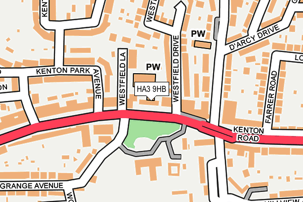
HA3 9HB is located in the Kenton East electoral ward, within the London borough of Harrow and the English Parliamentary constituency of Harrow East. The Sub Integrated Care Board (ICB) Location is NHS North West London ICB - W2U3Z and the police force is Metropolitan Police. This postcode has been in use since January 1980.


GetTheData
Source: OS OpenMap – Local (Ordnance Survey)
Source: OS VectorMap District (Ordnance Survey)
Licence: Open Government Licence (requires attribution)
| Easting | 517789 |
| Northing | 188993 |
| Latitude | 51.587489 |
| Longitude | -0.301195 |
GetTheData
Source: Open Postcode Geo
Licence: Open Government Licence
| Country | England |
| Postcode District | HA3 |
➜ See where HA3 is on a map ➜ Where is Kenton? | |
GetTheData
Source: Land Registry Price Paid Data
Licence: Open Government Licence
Elevation or altitude of HA3 9HB as distance above sea level:
| Metres | Feet | |
|---|---|---|
| Elevation | 40m | 131ft |
Elevation is measured from the approximate centre of the postcode, to the nearest point on an OS contour line from OS Terrain 50, which has contour spacing of ten vertical metres.
➜ How high above sea level am I? Find the elevation of your current position using your device's GPS.
GetTheData
Source: Open Postcode Elevation
Licence: Open Government Licence
| Ward | Kenton East |
| Constituency | Harrow East |
GetTheData
Source: ONS Postcode Database
Licence: Open Government Licence
| Kenton Park Avenue | Kenton | 119m |
| Kenton Park Avenue | Kenton | 175m |
| Charlton Road | Kenton | 185m |
| Charlton Road | Kenton | 186m |
| Kenton Lane | Kenton | 351m |
| Kenton Underground Station | Kenton | 1,262m |
| Queensbury Underground Station | Queensbury | 1,277m |
| Northwick Park Underground Station | Northwick Park | 1,539m |
| Kenton Station | 1.3km |
| South Kenton Station | 2km |
| Harrow & Wealdstone Station | 2.4km |
GetTheData
Source: NaPTAN
Licence: Open Government Licence
GetTheData
Source: ONS Postcode Database
Licence: Open Government Licence


➜ Get more ratings from the Food Standards Agency
GetTheData
Source: Food Standards Agency
Licence: FSA terms & conditions
| Last Collection | |||
|---|---|---|---|
| Location | Mon-Fri | Sat | Distance |
| Kenton Road | 17:00 | 12:00 | 67m |
| Shrewsbury Avenue | 17:30 | 11:45 | 260m |
| Kenton Park Post Office | 17:00 | 11:45 | 368m |
GetTheData
Source: Dracos
Licence: Creative Commons Attribution-ShareAlike
The below table lists the International Territorial Level (ITL) codes (formerly Nomenclature of Territorial Units for Statistics (NUTS) codes) and Local Administrative Units (LAU) codes for HA3 9HB:
| ITL 1 Code | Name |
|---|---|
| TLI | London |
| ITL 2 Code | Name |
| TLI7 | Outer London - West and North West |
| ITL 3 Code | Name |
| TLI74 | Harrow and Hillingdon |
| LAU 1 Code | Name |
| E09000015 | Harrow |
GetTheData
Source: ONS Postcode Directory
Licence: Open Government Licence
The below table lists the Census Output Area (OA), Lower Layer Super Output Area (LSOA), and Middle Layer Super Output Area (MSOA) for HA3 9HB:
| Code | Name | |
|---|---|---|
| OA | E00010874 | |
| LSOA | E01002171 | Harrow 033B |
| MSOA | E02006882 | Harrow 033 |
GetTheData
Source: ONS Postcode Directory
Licence: Open Government Licence
| HA3 9DW | Kenton Road | 72m |
| HA3 9EG | Westfield Drive | 82m |
| HA3 9BH | Kenton Road | 105m |
| HA3 0XX | Kenton Road | 123m |
| HA3 9EA | Westfield Lane | 136m |
| HA3 9EQ | Westfield Drive | 136m |
| HA3 8DS | Kenton Park Avenue | 142m |
| HA3 0XT | Kenton Road | 153m |
| HA3 9HW | Charlton Road | 155m |
| HA3 9HP | Charlton Road | 160m |
GetTheData
Source: Open Postcode Geo; Land Registry Price Paid Data
Licence: Open Government Licence