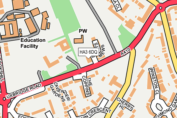
HA3 6DQ is located in the Harrow Weald electoral ward, within the London borough of Harrow and the English Parliamentary constituency of Harrow East. The Sub Integrated Care Board (ICB) Location is NHS North West London ICB - W2U3Z and the police force is Metropolitan Police. This postcode has been in use since July 1995.


GetTheData
Source: OS OpenMap – Local (Ordnance Survey)
Source: OS VectorMap District (Ordnance Survey)
Licence: Open Government Licence (requires attribution)
| Easting | 515363 |
| Northing | 191662 |
| Latitude | 51.611981 |
| Longitude | -0.335297 |
GetTheData
Source: Open Postcode Geo
Licence: Open Government Licence
| Country | England |
| Postcode District | HA3 |
➜ See where HA3 is on a map ➜ Where is London? | |
GetTheData
Source: Land Registry Price Paid Data
Licence: Open Government Licence
Elevation or altitude of HA3 6DQ as distance above sea level:
| Metres | Feet | |
|---|---|---|
| Elevation | 100m | 328ft |
Elevation is measured from the approximate centre of the postcode, to the nearest point on an OS contour line from OS Terrain 50, which has contour spacing of ten vertical metres.
➜ How high above sea level am I? Find the elevation of your current position using your device's GPS.
GetTheData
Source: Open Postcode Elevation
Licence: Open Government Licence
| Ward | Harrow Weald |
| Constituency | Harrow East |
GetTheData
Source: ONS Postcode Database
Licence: Open Government Licence
| All Saints Mews (Uxbridge Road) | Harrow Weald | 41m |
| All Saints Mews (Uxbridge Road) | Harrow Weald | 67m |
| Brookshill | Harrow Weald | 199m |
| Brockhurst Corner | Harrow Weald | 226m |
| Brockhurst Corner (Kenton Lane) | Harrow Weald | 292m |
| Headstone Lane Station | 1.8km |
| Harrow & Wealdstone Station | 2.2km |
| Hatch End Station | 2.3km |
GetTheData
Source: NaPTAN
Licence: Open Government Licence
GetTheData
Source: ONS Postcode Database
Licence: Open Government Licence


➜ Get more ratings from the Food Standards Agency
GetTheData
Source: Food Standards Agency
Licence: FSA terms & conditions
| Last Collection | |||
|---|---|---|---|
| Location | Mon-Fri | Sat | Distance |
| 45 Sitwell Grove | 17:45 | 11:45 | 613m |
| Langton Road | 18:15 | 13:00 | 1,200m |
| High Road Post Office | 17:00 | 12:30 | 1,232m |
GetTheData
Source: Dracos
Licence: Creative Commons Attribution-ShareAlike
The below table lists the International Territorial Level (ITL) codes (formerly Nomenclature of Territorial Units for Statistics (NUTS) codes) and Local Administrative Units (LAU) codes for HA3 6DQ:
| ITL 1 Code | Name |
|---|---|
| TLI | London |
| ITL 2 Code | Name |
| TLI7 | Outer London - West and North West |
| ITL 3 Code | Name |
| TLI74 | Harrow and Hillingdon |
| LAU 1 Code | Name |
| E09000015 | Harrow |
GetTheData
Source: ONS Postcode Directory
Licence: Open Government Licence
The below table lists the Census Output Area (OA), Lower Layer Super Output Area (LSOA), and Middle Layer Super Output Area (MSOA) for HA3 6DQ:
| Code | Name | |
|---|---|---|
| OA | E00010747 | |
| LSOA | E01002145 | Harrow 005E |
| MSOA | E02000437 | Harrow 005 |
GetTheData
Source: ONS Postcode Directory
Licence: Open Government Licence
| HA3 6DY | All Saints Mews | 54m |
| HA3 6DT | The Coppins | 114m |
| HA3 6DG | Uxbridge Road | 117m |
| HA3 6DW | Charlwood Close | 135m |
| HA3 6DD | Lavender Gardens | 159m |
| HA3 6BT | Elms Road | 179m |
| HA3 6DP | Kelvin Crescent | 194m |
| HA7 3JR | Acacia Close | 211m |
| HA3 6DJ | Uxbridge Road | 214m |
| HA3 6BS | Elms Road | 235m |
GetTheData
Source: Open Postcode Geo; Land Registry Price Paid Data
Licence: Open Government Licence