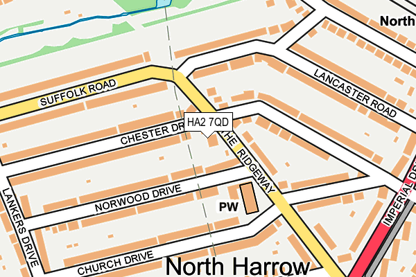
HA2 7QD lies on The Ridgeway in North Harrow, Harrow. HA2 7QD is located in the North Harrow electoral ward, within the London borough of Harrow and the English Parliamentary constituency of Harrow West. The Sub Integrated Care Board (ICB) Location is NHS North West London ICB - W2U3Z and the police force is Metropolitan Police. This postcode has been in use since January 1980.


GetTheData
Source: OS OpenMap – Local (Ordnance Survey)
Source: OS VectorMap District (Ordnance Survey)
Licence: Open Government Licence (requires attribution)
| Easting | 513187 |
| Northing | 188454 |
| Latitude | 51.583587 |
| Longitude | -0.367766 |
GetTheData
Source: Open Postcode Geo
Licence: Open Government Licence
| Street | The Ridgeway |
| Locality | North Harrow |
| Town/City | Harrow |
| Country | England |
| Postcode District | HA2 |
➜ See where HA2 is on a map ➜ Where is Harrow? | |
GetTheData
Source: Land Registry Price Paid Data
Licence: Open Government Licence
Elevation or altitude of HA2 7QD as distance above sea level:
| Metres | Feet | |
|---|---|---|
| Elevation | 50m | 164ft |
Elevation is measured from the approximate centre of the postcode, to the nearest point on an OS contour line from OS Terrain 50, which has contour spacing of ten vertical metres.
➜ How high above sea level am I? Find the elevation of your current position using your device's GPS.
GetTheData
Source: Open Postcode Elevation
Licence: Open Government Licence
| Ward | North Harrow |
| Constituency | Harrow West |
GetTheData
Source: ONS Postcode Database
Licence: Open Government Licence
2010 26 NOV £499,950 |
106, THE RIDGEWAY, NORTH HARROW, HARROW, HA2 7QD 2006 27 OCT £495,000 |
2001 1 JUN £275,000 |
106, THE RIDGEWAY, NORTH HARROW, HARROW, HA2 7QD 2000 12 APR £250,000 |
108, THE RIDGEWAY, NORTH HARROW, HARROW, HA2 7QD 1998 29 SEP £202,500 |
GetTheData
Source: HM Land Registry Price Paid Data
Licence: Contains HM Land Registry data © Crown copyright and database right 2025. This data is licensed under the Open Government Licence v3.0.
| Church Drive (The Ridgeway) | North Harrow | 96m |
| Church Drive (The Ridgeway) | North Harrow | 175m |
| Suffolk Road (Ha2) (Suffolk Road) | North Harrow | 249m |
| The Ridgeway (Ha2) | North Harrow | 277m |
| Suffolk Road (Ha2) (Suffolk Road) | North Harrow | 288m |
| North Harrow Underground Station | North Harrow | 398m |
| Rayners Lane Underground Station | Rayners Lane | 968m |
| West Harrow Underground Station | West Harrow | 1,085m |
| Pinner Underground Station | Pinner | 1,391m |
| Harrow-on-the-Hill Station | 2.2km |
| Headstone Lane Station | 2.2km |
| Harrow & Wealdstone Station | 2.5km |
GetTheData
Source: NaPTAN
Licence: Open Government Licence
| Percentage of properties with Next Generation Access | 100.0% |
| Percentage of properties with Superfast Broadband | 100.0% |
| Percentage of properties with Ultrafast Broadband | 100.0% |
| Percentage of properties with Full Fibre Broadband | 0.0% |
Superfast Broadband is between 30Mbps and 300Mbps
Ultrafast Broadband is > 300Mbps
| Percentage of properties unable to receive 2Mbps | 0.0% |
| Percentage of properties unable to receive 5Mbps | 0.0% |
| Percentage of properties unable to receive 10Mbps | 0.0% |
| Percentage of properties unable to receive 30Mbps | 0.0% |
GetTheData
Source: Ofcom
Licence: Ofcom Terms of Use (requires attribution)
GetTheData
Source: ONS Postcode Database
Licence: Open Government Licence


➜ Get more ratings from the Food Standards Agency
GetTheData
Source: Food Standards Agency
Licence: FSA terms & conditions
| Last Collection | |||
|---|---|---|---|
| Location | Mon-Fri | Sat | Distance |
| Lankers Drive | 17:00 | 12:45 | 311m |
| Church Avenue | 17:30 | 13:00 | 422m |
| The Drive | 17:30 | 12:45 | 446m |
GetTheData
Source: Dracos
Licence: Creative Commons Attribution-ShareAlike
The below table lists the International Territorial Level (ITL) codes (formerly Nomenclature of Territorial Units for Statistics (NUTS) codes) and Local Administrative Units (LAU) codes for HA2 7QD:
| ITL 1 Code | Name |
|---|---|
| TLI | London |
| ITL 2 Code | Name |
| TLI7 | Outer London - West and North West |
| ITL 3 Code | Name |
| TLI74 | Harrow and Hillingdon |
| LAU 1 Code | Name |
| E09000015 | Harrow |
GetTheData
Source: ONS Postcode Directory
Licence: Open Government Licence
The below table lists the Census Output Area (OA), Lower Layer Super Output Area (LSOA), and Middle Layer Super Output Area (MSOA) for HA2 7QD:
| Code | Name | |
|---|---|---|
| OA | E00010803 | |
| LSOA | E01002153 | Harrow 019A |
| MSOA | E02000451 | Harrow 019 |
GetTheData
Source: ONS Postcode Directory
Licence: Open Government Licence
| HA2 7QE | The Ridgeway | 57m |
| HA2 7PZ | The Ridgeway | 75m |
| HA2 7QH | Suffolk Road | 109m |
| HA2 7PT | Chester Drive | 111m |
| HA2 7PE | Norwood Drive | 115m |
| HA2 7PF | Norwood Drive | 143m |
| HA2 7QQ | Suffolk Road | 148m |
| HA2 7PU | Chester Drive | 151m |
| HA2 7PX | Chester Drive | 158m |
| HA2 7PY | Chester Drive | 164m |
GetTheData
Source: Open Postcode Geo; Land Registry Price Paid Data
Licence: Open Government Licence