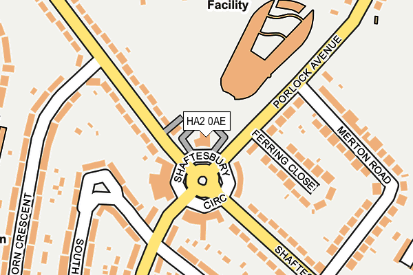
HA2 0AE lies on Shaftesbury Avenue in South Harrow, Harrow. HA2 0AE is located in the West Harrow electoral ward, within the London borough of Harrow and the English Parliamentary constituency of Harrow West. The Sub Integrated Care Board (ICB) Location is NHS North West London ICB - W2U3Z and the police force is Metropolitan Police. This postcode has been in use since January 1980.


GetTheData
Source: OS OpenMap – Local (Ordnance Survey)
Source: OS VectorMap District (Ordnance Survey)
Licence: Open Government Licence (requires attribution)
| Easting | 514189 |
| Northing | 187272 |
| Latitude | 51.572762 |
| Longitude | -0.353694 |
GetTheData
Source: Open Postcode Geo
Licence: Open Government Licence
| Street | Shaftesbury Avenue |
| Locality | South Harrow |
| Town/City | Harrow |
| Country | England |
| Postcode District | HA2 |
➜ See where HA2 is on a map ➜ Where is Harrow? | |
GetTheData
Source: Land Registry Price Paid Data
Licence: Open Government Licence
Elevation or altitude of HA2 0AE as distance above sea level:
| Metres | Feet | |
|---|---|---|
| Elevation | 60m | 197ft |
Elevation is measured from the approximate centre of the postcode, to the nearest point on an OS contour line from OS Terrain 50, which has contour spacing of ten vertical metres.
➜ How high above sea level am I? Find the elevation of your current position using your device's GPS.
GetTheData
Source: Open Postcode Elevation
Licence: Open Government Licence
| Ward | West Harrow |
| Constituency | Harrow West |
GetTheData
Source: ONS Postcode Database
Licence: Open Government Licence
THE SHAFTESBURY, SHAFTESBURY AVENUE, SOUTH HARROW, HARROW, HA2 0AE 1999 31 AUG £856,600 |
GetTheData
Source: HM Land Registry Price Paid Data
Licence: Contains HM Land Registry data © Crown copyright and database right 2025. This data is licensed under the Open Government Licence v3.0.
| Porlock Avenue (Shaftesbury Avenue) | Roxeth | 37m |
| Porlock Avenue | Roxeth | 40m |
| Drury Road (Whitmore Road) | West Harrow | 298m |
| Drury Road (Whitmore Road) | West Harrow | 303m |
| Treve Avenue Whitmore Road (Porlock Avenue) | West Harrow | 312m |
| West Harrow Underground Station | West Harrow | 773m |
| South Harrow Underground Station | South Harrow | 880m |
| Rayners Lane Underground Station | Rayners Lane | 1,237m |
| Harrow-on-the-hill Underground Station | Harrow | 1,347m |
| North Harrow Underground Station | North Harrow | 1,476m |
| Harrow-on-the-Hill Station | 1.3km |
| Northolt Park Station | 1.7km |
| Sudbury Hill Harrow Station | 2km |
GetTheData
Source: NaPTAN
Licence: Open Government Licence
GetTheData
Source: ONS Postcode Database
Licence: Open Government Licence


➜ Get more ratings from the Food Standards Agency
GetTheData
Source: Food Standards Agency
Licence: FSA terms & conditions
| Last Collection | |||
|---|---|---|---|
| Location | Mon-Fri | Sat | Distance |
| Shatesbury Avenue Post Office | 17:30 | 12:15 | 95m |
| Capthorne Avenue | 18:00 | 12:00 | 173m |
| Drury Road | 17:45 | 11:30 | 308m |
GetTheData
Source: Dracos
Licence: Creative Commons Attribution-ShareAlike
The below table lists the International Territorial Level (ITL) codes (formerly Nomenclature of Territorial Units for Statistics (NUTS) codes) and Local Administrative Units (LAU) codes for HA2 0AE:
| ITL 1 Code | Name |
|---|---|
| TLI | London |
| ITL 2 Code | Name |
| TLI7 | Outer London - West and North West |
| ITL 3 Code | Name |
| TLI74 | Harrow and Hillingdon |
| LAU 1 Code | Name |
| E09000015 | Harrow |
GetTheData
Source: ONS Postcode Directory
Licence: Open Government Licence
The below table lists the Census Output Area (OA), Lower Layer Super Output Area (LSOA), and Middle Layer Super Output Area (MSOA) for HA2 0AE:
| Code | Name | |
|---|---|---|
| OA | E00010726 | |
| LSOA | E01002136 | Harrow 027B |
| MSOA | E02000459 | Harrow 027 |
GetTheData
Source: ONS Postcode Directory
Licence: Open Government Licence
| HA2 0AX | Shaftesbury Avenue | 48m |
| HA2 0AG | Shaftesbury Circle | 83m |
| HA2 0AJ | Shaftesbury Parade | 89m |
| HA2 0AP | Porlock Avenue | 107m |
| HA2 0AT | Shaftesbury Circle | 116m |
| HA2 0AH | Shaftesbury Parade | 120m |
| HA2 0AL | Shaftesbury Avenue | 121m |
| HA2 0AR | Ferring Close | 139m |
| HA2 0QG | Roxeth Green Avenue | 141m |
| HA2 0QP | Roxeth Green Avenue | 150m |
GetTheData
Source: Open Postcode Geo; Land Registry Price Paid Data
Licence: Open Government Licence