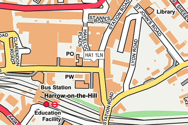
HA1 1LN is located in the Greenhill electoral ward, within the London borough of Harrow and the English Parliamentary constituency of Harrow West. The Sub Integrated Care Board (ICB) Location is NHS North West London ICB - W2U3Z and the police force is Metropolitan Police. This postcode has been in use since April 2022.


GetTheData
Source: OS OpenMap – Local (Ordnance Survey)
Source: OS VectorMap District (Ordnance Survey)
Licence: Open Government Licence (requires attribution)
| Easting | 515493 |
| Northing | 188124 |
| Latitude | 51.580156 |
| Longitude | -0.334584 |
GetTheData
Source: Open Postcode Geo
Licence: Open Government Licence
| Country | England |
| Postcode District | HA1 |
➜ See where HA1 is on a map ➜ Where is Harrow? | |
GetTheData
Source: Land Registry Price Paid Data
Licence: Open Government Licence
Elevation or altitude of HA1 1LN as distance above sea level:
| Metres | Feet | |
|---|---|---|
| Elevation | 70m | 230ft |
Elevation is measured from the approximate centre of the postcode, to the nearest point on an OS contour line from OS Terrain 50, which has contour spacing of ten vertical metres.
➜ How high above sea level am I? Find the elevation of your current position using your device's GPS.
GetTheData
Source: Open Postcode Elevation
Licence: Open Government Licence
| Ward | Greenhill |
| Constituency | Harrow West |
GetTheData
Source: ONS Postcode Database
Licence: Open Government Licence
| Harrow Town Centre | Harrow | 79m |
| Harrow Town Centre (Station Road) | Harrow | 81m |
| Harrow Town Centre | Harrow | 81m |
| Harrow Town Centre (Station Road) | Harrow | 98m |
| Greenhill Way | Harrow | 195m |
| Harrow-on-the-hill Underground Station | Harrow | 211m |
| Northwick Park Underground Station | Northwick Park | 1,162m |
| Kenton Underground Station | Kenton | 1,239m |
| West Harrow Underground Station | West Harrow | 1,303m |
| Harrow & Wealdstone Underground Station | Harrow & Wealdstone | 1,348m |
| Harrow-on-the-Hill Station | 0.2km |
| Kenton Station | 1.2km |
| Harrow & Wealdstone Station | 1.3km |
GetTheData
Source: NaPTAN
Licence: Open Government Licence
GetTheData
Source: ONS Postcode Database
Licence: Open Government Licence


➜ Get more ratings from the Food Standards Agency
GetTheData
Source: Food Standards Agency
Licence: FSA terms & conditions
| Last Collection | |||
|---|---|---|---|
| Location | Mon-Fri | Sat | Distance |
| Harrow Post Office | 19:00 | 13:00 | 150m |
| College Road | 19:00 | 189m | |
| College Road | 193m | ||
GetTheData
Source: Dracos
Licence: Creative Commons Attribution-ShareAlike
The below table lists the International Territorial Level (ITL) codes (formerly Nomenclature of Territorial Units for Statistics (NUTS) codes) and Local Administrative Units (LAU) codes for HA1 1LN:
| ITL 1 Code | Name |
|---|---|
| TLI | London |
| ITL 2 Code | Name |
| TLI7 | Outer London - West and North West |
| ITL 3 Code | Name |
| TLI74 | Harrow and Hillingdon |
| LAU 1 Code | Name |
| E09000015 | Harrow |
GetTheData
Source: ONS Postcode Directory
Licence: Open Government Licence
The below table lists the Census Output Area (OA), Lower Layer Super Output Area (LSOA), and Middle Layer Super Output Area (MSOA) for HA1 1LN:
| Code | Name | |
|---|---|---|
| OA | E00010660 | |
| LSOA | E01002129 | Harrow 023C |
| MSOA | E02000455 | Harrow 023 |
GetTheData
Source: ONS Postcode Directory
Licence: Open Government Licence
| HA1 1AY | College Road | 9m |
| HA1 1BA | College Road | 43m |
| HA1 2AA | Station Road | 63m |
| HA1 2AW | Station Road | 76m |
| HA1 2DE | Station Road | 81m |
| HA1 1BE | College Road | 98m |
| HA1 1JU | St Anns Road | 129m |
| HA1 2DX | Station Road | 139m |
| HA1 2EX | Lyon Road | 144m |
| HA1 1LG | St Anns Road | 155m |
GetTheData
Source: Open Postcode Geo; Land Registry Price Paid Data
Licence: Open Government Licence