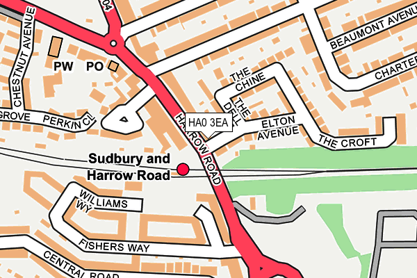
HA0 3EA is located in the Sudbury electoral ward, within the London borough of Brent and the English Parliamentary constituency of Brent North. The Sub Integrated Care Board (ICB) Location is NHS North West London ICB - W2U3Z and the police force is Metropolitan Police. This postcode has been in use since January 1980.


GetTheData
Source: OS OpenMap – Local (Ordnance Survey)
Source: OS VectorMap District (Ordnance Survey)
Licence: Open Government Licence (requires attribution)
| Easting | 516913 |
| Northing | 185330 |
| Latitude | 51.554750 |
| Longitude | -0.315051 |
GetTheData
Source: Open Postcode Geo
Licence: Open Government Licence
| Country | England |
| Postcode District | HA0 |
➜ See where HA0 is on a map ➜ Where is London? | |
GetTheData
Source: Land Registry Price Paid Data
Licence: Open Government Licence
Elevation or altitude of HA0 3EA as distance above sea level:
| Metres | Feet | |
|---|---|---|
| Elevation | 50m | 164ft |
Elevation is measured from the approximate centre of the postcode, to the nearest point on an OS contour line from OS Terrain 50, which has contour spacing of ten vertical metres.
➜ How high above sea level am I? Find the elevation of your current position using your device's GPS.
GetTheData
Source: Open Postcode Elevation
Licence: Open Government Licence
| Ward | Sudbury |
| Constituency | Brent North |
GetTheData
Source: ONS Postcode Database
Licence: Open Government Licence
| Sudbury & Harrow Road (Harrow Road) | Sudbury | 46m |
| Sudbury & Harrow Road | Sudbury | 66m |
| Rugby Avenue (Harrow Road) | Sudbury | 99m |
| Sudbury & Harrow Road (Harrow Road) | Sudbury | 112m |
| Harrow Road Sudbury | Sudbury | 277m |
| Sudbury Town Underground Station | Sudbury Town | 441m |
| North Wembley Underground Station | North Wembley | 1,157m |
| Wembley Central Underground Station | Wembley | 1,291m |
| Sudbury Hill Underground Station | Sudbury Hill | 1,503m |
| Sudbury & Harrow Road Station | 0km |
| North Wembley Station | 1.2km |
| Wembley Central Station | 1.3km |
GetTheData
Source: NaPTAN
Licence: Open Government Licence
GetTheData
Source: ONS Postcode Database
Licence: Open Government Licence


➜ Get more ratings from the Food Standards Agency
GetTheData
Source: Food Standards Agency
Licence: FSA terms & conditions
| Last Collection | |||
|---|---|---|---|
| Location | Mon-Fri | Sat | Distance |
| Harrow Road Post Office | 17:15 | 12:00 | 165m |
| 709 District Road | 17:00 | 12:00 | 203m |
| Central Road | 17:00 | 12:00 | 382m |
GetTheData
Source: Dracos
Licence: Creative Commons Attribution-ShareAlike
The below table lists the International Territorial Level (ITL) codes (formerly Nomenclature of Territorial Units for Statistics (NUTS) codes) and Local Administrative Units (LAU) codes for HA0 3EA:
| ITL 1 Code | Name |
|---|---|
| TLI | London |
| ITL 2 Code | Name |
| TLI7 | Outer London - West and North West |
| ITL 3 Code | Name |
| TLI72 | Brent |
| LAU 1 Code | Name |
| E09000005 | Brent |
GetTheData
Source: ONS Postcode Directory
Licence: Open Government Licence
The below table lists the Census Output Area (OA), Lower Layer Super Output Area (LSOA), and Middle Layer Super Output Area (MSOA) for HA0 3EA:
| Code | Name | |
|---|---|---|
| OA | E00002935 | |
| LSOA | E01000608 | Brent 013D |
| MSOA | E02000105 | Brent 013 |
GetTheData
Source: ONS Postcode Directory
Licence: Open Government Licence
| HA0 3EL | Harrow Road | 44m |
| HA0 3EJ | The Dell | 61m |
| HA0 2LW | Harrow Road | 69m |
| HA0 3EE | Elton Avenue | 72m |
| HA0 2HE | Harrow Road | 107m |
| HA0 2FP | Williams Way | 113m |
| HA0 3EH | The Chine | 119m |
| HA0 3EF | The Croft | 124m |
| HA0 2LZ | Sudbury Crescent | 137m |
| HA0 3DF | Rugby Avenue | 144m |
GetTheData
Source: Open Postcode Geo; Land Registry Price Paid Data
Licence: Open Government Licence