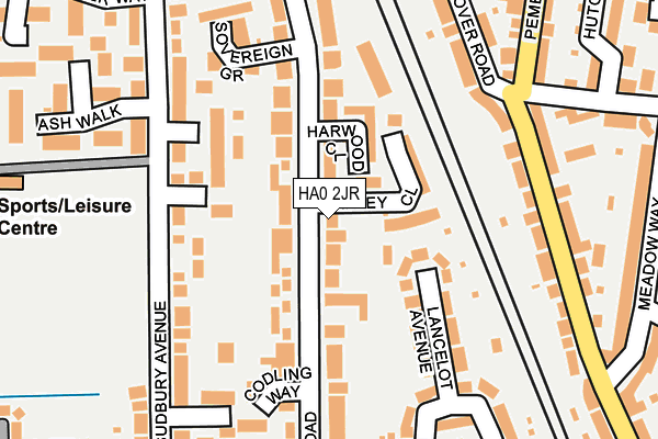
HA0 2JR lies on Harrowdene Road in Wembley. HA0 2JR is located in the Sudbury electoral ward, within the London borough of Brent and the English Parliamentary constituency of Brent North. The Sub Integrated Care Board (ICB) Location is NHS North West London ICB - W2U3Z and the police force is Metropolitan Police. This postcode has been in use since January 1980.


GetTheData
Source: OS OpenMap – Local (Ordnance Survey)
Source: OS VectorMap District (Ordnance Survey)
Licence: Open Government Licence (requires attribution)
| Easting | 517663 |
| Northing | 185905 |
| Latitude | 51.559762 |
| Longitude | -0.304046 |
GetTheData
Source: Open Postcode Geo
Licence: Open Government Licence
| Street | Harrowdene Road |
| Town/City | Wembley |
| Country | England |
| Postcode District | HA0 |
➜ See where HA0 is on a map ➜ Where is Wembley? | |
GetTheData
Source: Land Registry Price Paid Data
Licence: Open Government Licence
Elevation or altitude of HA0 2JR as distance above sea level:
| Metres | Feet | |
|---|---|---|
| Elevation | 40m | 131ft |
Elevation is measured from the approximate centre of the postcode, to the nearest point on an OS contour line from OS Terrain 50, which has contour spacing of ten vertical metres.
➜ How high above sea level am I? Find the elevation of your current position using your device's GPS.
GetTheData
Source: Open Postcode Elevation
Licence: Open Government Licence
| Ward | Sudbury |
| Constituency | Brent North |
GetTheData
Source: ONS Postcode Database
Licence: Open Government Licence
| North Wembley Station (East Lane) | North Wembley | 330m |
| North Wembley Station (East Lane) | North Wembley | 347m |
| Pembroke Road (Ha9) | North Wembley | 399m |
| Pembroke Road (Ha9) | North Wembley | 401m |
| Rosslyn Crescent | North Wembley | 551m |
| North Wembley Underground Station | North Wembley | 310m |
| Wembley Central Underground Station | Wembley | 968m |
| South Kenton Underground Station | South Kenton | 1,203m |
| Sudbury Town Underground Station | Sudbury Town | 1,284m |
| Preston Road Underground Station | Preston | 1,493m |
| North Wembley Station | 0.3km |
| Wembley Central Station | 1km |
| Sudbury & Harrow Road Station | 1km |
GetTheData
Source: NaPTAN
Licence: Open Government Licence
| Percentage of properties with Next Generation Access | 100.0% |
| Percentage of properties with Superfast Broadband | 100.0% |
| Percentage of properties with Ultrafast Broadband | 100.0% |
| Percentage of properties with Full Fibre Broadband | 0.0% |
Superfast Broadband is between 30Mbps and 300Mbps
Ultrafast Broadband is > 300Mbps
| Percentage of properties unable to receive 2Mbps | 0.0% |
| Percentage of properties unable to receive 5Mbps | 0.0% |
| Percentage of properties unable to receive 10Mbps | 0.0% |
| Percentage of properties unable to receive 30Mbps | 0.0% |
GetTheData
Source: Ofcom
Licence: Ofcom Terms of Use (requires attribution)
GetTheData
Source: ONS Postcode Database
Licence: Open Government Licence


➜ Get more ratings from the Food Standards Agency
GetTheData
Source: Food Standards Agency
Licence: FSA terms & conditions
| Last Collection | |||
|---|---|---|---|
| Location | Mon-Fri | Sat | Distance |
| Harrowdene Road | 17:45 | 12:45 | 53m |
| Sudbury Avenue | 17:45 | 12:30 | 285m |
| Harrowdene Road | 17:45 | 12:45 | 322m |
GetTheData
Source: Dracos
Licence: Creative Commons Attribution-ShareAlike
The below table lists the International Territorial Level (ITL) codes (formerly Nomenclature of Territorial Units for Statistics (NUTS) codes) and Local Administrative Units (LAU) codes for HA0 2JR:
| ITL 1 Code | Name |
|---|---|
| TLI | London |
| ITL 2 Code | Name |
| TLI7 | Outer London - West and North West |
| ITL 3 Code | Name |
| TLI72 | Brent |
| LAU 1 Code | Name |
| E09000005 | Brent |
GetTheData
Source: ONS Postcode Directory
Licence: Open Government Licence
The below table lists the Census Output Area (OA), Lower Layer Super Output Area (LSOA), and Middle Layer Super Output Area (MSOA) for HA0 2JR:
| Code | Name | |
|---|---|---|
| OA | E00002931 | |
| LSOA | E01000613 | Brent 013E |
| MSOA | E02000105 | Brent 013 |
GetTheData
Source: ONS Postcode Directory
Licence: Open Government Licence
| HA0 2JF | Harrowdene Road | 15m |
| HA0 2JJ | Harrowdene Road | 60m |
| HA0 2JL | Harrowdene Road | 61m |
| HA0 2HS | Harwood Close | 79m |
| HA0 2JN | Harrowdene Road | 80m |
| HA0 2JP | Harrowdene Road | 97m |
| HA0 3BJ | Rustic Place | 110m |
| HA0 2BA | Lancelot Avenue | 115m |
| HA0 3BQ | Sudbury Avenue | 121m |
| HA0 3BH | Waylett Place | 134m |
GetTheData
Source: Open Postcode Geo; Land Registry Price Paid Data
Licence: Open Government Licence