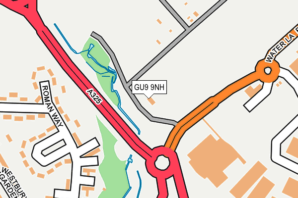
GU9 9NH lies on Water Lane in Farnham. GU9 9NH is located in the Farnham Weybourne electoral ward, within the local authority district of Waverley and the English Parliamentary constituency of South West Surrey. The Sub Integrated Care Board (ICB) Location is NHS Frimley ICB - D4U1Y and the police force is Surrey. This postcode has been in use since January 1980.


GetTheData
Source: OS OpenMap – Local (Ordnance Survey)
Source: OS VectorMap District (Ordnance Survey)
Licence: Open Government Licence (requires attribution)
| Easting | 485364 |
| Northing | 147816 |
| Latitude | 51.223164 |
| Longitude | -0.778969 |
GetTheData
Source: Open Postcode Geo
Licence: Open Government Licence
| Street | Water Lane |
| Town/City | Farnham |
| Country | England |
| Postcode District | GU9 |
➜ See where GU9 is on a map ➜ Where is Farnham? | |
GetTheData
Source: Land Registry Price Paid Data
Licence: Open Government Licence
Elevation or altitude of GU9 9NH as distance above sea level:
| Metres | Feet | |
|---|---|---|
| Elevation | 70m | 230ft |
Elevation is measured from the approximate centre of the postcode, to the nearest point on an OS contour line from OS Terrain 50, which has contour spacing of ten vertical metres.
➜ How high above sea level am I? Find the elevation of your current position using your device's GPS.
GetTheData
Source: Open Postcode Elevation
Licence: Open Government Licence
| Ward | Farnham Weybourne |
| Constituency | South West Surrey |
GetTheData
Source: ONS Postcode Database
Licence: Open Government Licence
| Sainsburys (Water Lane) | Farnham | 133m |
| Sainsburys (Water Lane) | Farnham | 167m |
| Six Bells Roundabout (Weybourne Road) | Farnham | 349m |
| Six Bells Roundabout (Weybourne Road) | Farnham | 359m |
| Farnham Hospital North (Hale Road) | Farnham | 412m |
| Farnham Station | 1.6km |
| Aldershot Station | 2.9km |
| Ash Station | 5.5km |
GetTheData
Source: NaPTAN
Licence: Open Government Licence
| Percentage of properties with Next Generation Access | 100.0% |
| Percentage of properties with Superfast Broadband | 50.0% |
| Percentage of properties with Ultrafast Broadband | 0.0% |
| Percentage of properties with Full Fibre Broadband | 0.0% |
Superfast Broadband is between 30Mbps and 300Mbps
Ultrafast Broadband is > 300Mbps
| Percentage of properties unable to receive 2Mbps | 0.0% |
| Percentage of properties unable to receive 5Mbps | 0.0% |
| Percentage of properties unable to receive 10Mbps | 0.0% |
| Percentage of properties unable to receive 30Mbps | 50.0% |
GetTheData
Source: Ofcom
Licence: Ofcom Terms of Use (requires attribution)
GetTheData
Source: ONS Postcode Database
Licence: Open Government Licence


➜ Get more ratings from the Food Standards Agency
GetTheData
Source: Food Standards Agency
Licence: FSA terms & conditions
| Last Collection | |||
|---|---|---|---|
| Location | Mon-Fri | Sat | Distance |
| J Sainburys | 17:00 | 11:45 | 153m |
| Hale Road | 17:15 | 12:00 | 416m |
| Hurlands Place | 17:00 | 08:15 | 502m |
GetTheData
Source: Dracos
Licence: Creative Commons Attribution-ShareAlike
The below table lists the International Territorial Level (ITL) codes (formerly Nomenclature of Territorial Units for Statistics (NUTS) codes) and Local Administrative Units (LAU) codes for GU9 9NH:
| ITL 1 Code | Name |
|---|---|
| TLJ | South East (England) |
| ITL 2 Code | Name |
| TLJ2 | Surrey, East and West Sussex |
| ITL 3 Code | Name |
| TLJ25 | West Surrey |
| LAU 1 Code | Name |
| E07000216 | Waverley |
GetTheData
Source: ONS Postcode Directory
Licence: Open Government Licence
The below table lists the Census Output Area (OA), Lower Layer Super Output Area (LSOA), and Middle Layer Super Output Area (MSOA) for GU9 9NH:
| Code | Name | |
|---|---|---|
| OA | E00157562 | |
| LSOA | E01030902 | Waverley 001B |
| MSOA | E02006439 | Waverley 001 |
GetTheData
Source: ONS Postcode Directory
Licence: Open Government Licence
| GU9 9RG | Roman Way | 209m |
| GU9 9RF | Roman Way | 249m |
| GU9 9RQ | Roman Way | 283m |
| GU9 9NP | Farnham Trading Estate | 292m |
| GU9 9RN | Westbury Gardens | 318m |
| GU9 9RD | Hale Road | 357m |
| GU9 9QY | Manor Road | 373m |
| GU9 9NN | Farnham Trading Estate | 377m |
| GU9 9QZ | Hale Road | 378m |
| GU9 9FE | Willbury Road | 383m |
GetTheData
Source: Open Postcode Geo; Land Registry Price Paid Data
Licence: Open Government Licence