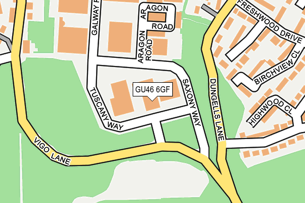
GU46 6GF is located in the Yateley West electoral ward, within the local authority district of Hart and the English Parliamentary constituency of North East Hampshire. The Sub Integrated Care Board (ICB) Location is NHS Frimley ICB - D4U1Y and the police force is Hampshire. This postcode has been in use since December 1996.


GetTheData
Source: OS OpenMap – Local (Ordnance Survey)
Source: OS VectorMap District (Ordnance Survey)
Licence: Open Government Licence (requires attribution)
| Easting | 481297 |
| Northing | 159594 |
| Latitude | 51.329642 |
| Longitude | -0.834536 |
GetTheData
Source: Open Postcode Geo
Licence: Open Government Licence
| Country | England |
| Postcode District | GU46 |
➜ See where GU46 is on a map ➜ Where is Yateley? | |
GetTheData
Source: Land Registry Price Paid Data
Licence: Open Government Licence
Elevation or altitude of GU46 6GF as distance above sea level:
| Metres | Feet | |
|---|---|---|
| Elevation | 90m | 295ft |
Elevation is measured from the approximate centre of the postcode, to the nearest point on an OS contour line from OS Terrain 50, which has contour spacing of ten vertical metres.
➜ How high above sea level am I? Find the elevation of your current position using your device's GPS.
GetTheData
Source: Open Postcode Elevation
Licence: Open Government Licence
| Ward | Yateley West |
| Constituency | North East Hampshire |
GetTheData
Source: ONS Postcode Database
Licence: Open Government Licence
| Dickens Way (Vigo Lane) | Yateley | 461m |
| Monteagle Lane | Yateley | 505m |
| Monteagle Lane | Yateley | 506m |
| Tudor Drive Shops (Tudor Drive) | Cricket Hill | 549m |
| Tudor Drive Shops (Tudor Drive) | Cricket Hill | 553m |
| Sandhurst Station | 2.8km |
| Blackwater Station | 4km |
| Crowthorne Station | 4.3km |
GetTheData
Source: NaPTAN
Licence: Open Government Licence
GetTheData
Source: ONS Postcode Database
Licence: Open Government Licence


➜ Get more ratings from the Food Standards Agency
GetTheData
Source: Food Standards Agency
Licence: FSA terms & conditions
| Last Collection | |||
|---|---|---|---|
| Location | Mon-Fri | Sat | Distance |
| Blackbushe Business Park | 17:15 | 11:30 | 33m |
| Tudor Drive Post Office | 16:15 | 11:30 | 524m |
| Wordsworth Avenue | 16:30 | 11:45 | 528m |
GetTheData
Source: Dracos
Licence: Creative Commons Attribution-ShareAlike
The below table lists the International Territorial Level (ITL) codes (formerly Nomenclature of Territorial Units for Statistics (NUTS) codes) and Local Administrative Units (LAU) codes for GU46 6GF:
| ITL 1 Code | Name |
|---|---|
| TLJ | South East (England) |
| ITL 2 Code | Name |
| TLJ3 | Hampshire and Isle of Wight |
| ITL 3 Code | Name |
| TLJ37 | North Hampshire |
| LAU 1 Code | Name |
| E07000089 | Hart |
GetTheData
Source: ONS Postcode Directory
Licence: Open Government Licence
The below table lists the Census Output Area (OA), Lower Layer Super Output Area (LSOA), and Middle Layer Super Output Area (MSOA) for GU46 6GF:
| Code | Name | |
|---|---|---|
| OA | E00116344 | |
| LSOA | E01022898 | Hart 002E |
| MSOA | E02004752 | Hart 002 |
GetTheData
Source: ONS Postcode Directory
Licence: Open Government Licence
| GU46 6DN | Silver Glades | 200m |
| GU46 6DG | Highwood Close | 212m |
| GU46 6EB | Wildwood Gardens | 230m |
| GU46 6DL | Birchview Close | 245m |
| GU46 6DF | Tudor Drive | 258m |
| GU46 6EY | Dungells Lane | 260m |
| GU46 6DJ | Freshwood Drive | 272m |
| GU46 6YD | Christie Walk | 290m |
| GU46 6DH | Freshwood Drive | 305m |
| GU46 6EP | Vigo Lane | 324m |
GetTheData
Source: Open Postcode Geo; Land Registry Price Paid Data
Licence: Open Government Licence