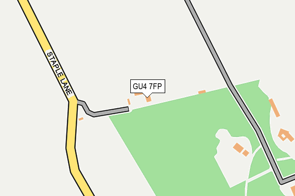
GU4 7FP lies on Staple Lane in East Clandon, Guildford. GU4 7FP is located in the Clandon & Horsley electoral ward, within the local authority district of Guildford and the English Parliamentary constituency of Mole Valley. The Sub Integrated Care Board (ICB) Location is NHS Surrey Heartlands ICB - 92A and the police force is Surrey. This postcode has been in use since January 2014.


GetTheData
Source: OS OpenMap – Local (Ordnance Survey)
Source: OS VectorMap District (Ordnance Survey)
Licence: Open Government Licence (requires attribution)
| Easting | 506183 |
| Northing | 151066 |
| Latitude | 51.248891 |
| Longitude | -0.480002 |
GetTheData
Source: Open Postcode Geo
Licence: Open Government Licence
| Street | Staple Lane |
| Locality | East Clandon |
| Town/City | Guildford |
| Country | England |
| Postcode District | GU4 |
➜ See where GU4 is on a map | |
GetTheData
Source: Land Registry Price Paid Data
Licence: Open Government Licence
Elevation or altitude of GU4 7FP as distance above sea level:
| Metres | Feet | |
|---|---|---|
| Elevation | 120m | 394ft |
Elevation is measured from the approximate centre of the postcode, to the nearest point on an OS contour line from OS Terrain 50, which has contour spacing of ten vertical metres.
➜ How high above sea level am I? Find the elevation of your current position using your device's GPS.
GetTheData
Source: Open Postcode Elevation
Licence: Open Government Licence
| Ward | Clandon & Horsley |
| Constituency | Mole Valley |
GetTheData
Source: ONS Postcode Database
Licence: Open Government Licence
| Hatchlands (Epsom Road) | East Clandon | 489m |
| Hatchlands (Epsom Road) | East Clandon | 504m |
| Epsom Road | East Clandon | 560m |
| Epsom Road | East Clandon | 679m |
| Hatchlands Park Nt (The Street) | East Clandon | 1,121m |
| Clandon Station | 2.3km |
| Gomshall Station | 4.2km |
| Horsley Station | 4.6km |
GetTheData
Source: NaPTAN
Licence: Open Government Licence
GetTheData
Source: ONS Postcode Database
Licence: Open Government Licence


➜ Get more ratings from the Food Standards Agency
GetTheData
Source: Food Standards Agency
Licence: FSA terms & conditions
| Last Collection | |||
|---|---|---|---|
| Location | Mon-Fri | Sat | Distance |
| East Clandon | 17:15 | 07:45 | 717m |
| Clandon Cross Roads | 17:30 | 07:00 | 1,507m |
| Newlands Corner | 16:30 | 07:00 | 1,665m |
GetTheData
Source: Dracos
Licence: Creative Commons Attribution-ShareAlike
The below table lists the International Territorial Level (ITL) codes (formerly Nomenclature of Territorial Units for Statistics (NUTS) codes) and Local Administrative Units (LAU) codes for GU4 7FP:
| ITL 1 Code | Name |
|---|---|
| TLJ | South East (England) |
| ITL 2 Code | Name |
| TLJ2 | Surrey, East and West Sussex |
| ITL 3 Code | Name |
| TLJ25 | West Surrey |
| LAU 1 Code | Name |
| E07000209 | Guildford |
GetTheData
Source: ONS Postcode Directory
Licence: Open Government Licence
The below table lists the Census Output Area (OA), Lower Layer Super Output Area (LSOA), and Middle Layer Super Output Area (MSOA) for GU4 7FP:
| Code | Name | |
|---|---|---|
| OA | E00155265 | |
| LSOA | E01030440 | Guildford 001A |
| MSOA | E02006344 | Guildford 001 |
GetTheData
Source: ONS Postcode Directory
Licence: Open Government Licence
| GU4 7RP | High Clandon | 281m |
| GU4 7RR | Blakes Lane | 388m |
| GU4 7RN | Epsom Road | 514m |
| GU4 7RS | School Lane | 607m |
| GU4 7RY | The Street | 644m |
| GU4 7RL | Epsom Road | 703m |
| GU4 7RX | The Street | 714m |
| GU4 7RU | The Street | 719m |
| GU4 7SE | Ripley Road | 784m |
| GU4 7SA | Back Lane | 798m |
GetTheData
Source: Open Postcode Geo; Land Registry Price Paid Data
Licence: Open Government Licence