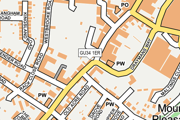
GU34 1ER is located in the Alton Westbrooke electoral ward, within the local authority district of East Hampshire and the English Parliamentary constituency of East Hampshire. The Sub Integrated Care Board (ICB) Location is NHS Hampshire and Isle of Wight ICB - D9Y0V and the police force is Hampshire. This postcode has been in use since January 1980.


GetTheData
Source: OS OpenMap – Local (Ordnance Survey)
Source: OS VectorMap District (Ordnance Survey)
Licence: Open Government Licence (requires attribution)
| Easting | 471562 |
| Northing | 139106 |
| Latitude | 51.146753 |
| Longitude | -0.978324 |
GetTheData
Source: Open Postcode Geo
Licence: Open Government Licence
| Country | England |
| Postcode District | GU34 |
➜ See where GU34 is on a map ➜ Where is Alton? | |
GetTheData
Source: Land Registry Price Paid Data
Licence: Open Government Licence
Elevation or altitude of GU34 1ER as distance above sea level:
| Metres | Feet | |
|---|---|---|
| Elevation | 110m | 361ft |
Elevation is measured from the approximate centre of the postcode, to the nearest point on an OS contour line from OS Terrain 50, which has contour spacing of ten vertical metres.
➜ How high above sea level am I? Find the elevation of your current position using your device's GPS.
GetTheData
Source: Open Postcode Elevation
Licence: Open Government Licence
| Ward | Alton Westbrooke |
| Constituency | East Hampshire |
GetTheData
Source: ONS Postcode Database
Licence: Open Government Licence
| Conservative Club | Alton | 168m |
| Sainsburys (Drayman's Way) | Alton | 178m |
| High Street | Alton | 181m |
| Sainsburys (Draymans Way) | Alton | 205m |
| High Street | Alton | 239m |
| Alton (Mid-hants Railway) | Alton | 987m |
| Alton Station | 1km |
GetTheData
Source: NaPTAN
Licence: Open Government Licence
GetTheData
Source: ONS Postcode Database
Licence: Open Government Licence

➜ Get more ratings from the Food Standards Agency
GetTheData
Source: Food Standards Agency
Licence: FSA terms & conditions
| Last Collection | |||
|---|---|---|---|
| Location | Mon-Fri | Sat | Distance |
| Alton Post Office | 18:30 | 12:45 | 89m |
| Lenten Street | 17:15 | 10:45 | 244m |
| Lower Turk Street | 17:30 | 10:30 | 268m |
GetTheData
Source: Dracos
Licence: Creative Commons Attribution-ShareAlike
The below table lists the International Territorial Level (ITL) codes (formerly Nomenclature of Territorial Units for Statistics (NUTS) codes) and Local Administrative Units (LAU) codes for GU34 1ER:
| ITL 1 Code | Name |
|---|---|
| TLJ | South East (England) |
| ITL 2 Code | Name |
| TLJ3 | Hampshire and Isle of Wight |
| ITL 3 Code | Name |
| TLJ36 | Central Hampshire |
| LAU 1 Code | Name |
| E07000085 | East Hampshire |
GetTheData
Source: ONS Postcode Directory
Licence: Open Government Licence
The below table lists the Census Output Area (OA), Lower Layer Super Output Area (LSOA), and Middle Layer Super Output Area (MSOA) for GU34 1ER:
| Code | Name | |
|---|---|---|
| OA | E00114773 | |
| LSOA | E01022576 | East Hampshire 002C |
| MSOA | E02004698 | East Hampshire 002 |
GetTheData
Source: ONS Postcode Directory
Licence: Open Government Licence
| GU34 1EN | High Street | 63m |
| GU34 1NE | Butts Road | 70m |
| GU34 1NG | Mount Pleasant Road | 98m |
| GU34 1EW | High Street | 108m |
| GU34 1NQ | Ackender Road | 113m |
| GU34 1NH | Mount Pleasant Road | 130m |
| GU34 1NR | Old Acre Road | 147m |
| GU34 1HL | Cross & Pillory Lane | 150m |
| GU34 1JW | Ackender Road | 151m |
| GU34 1AB | High Street | 162m |
GetTheData
Source: Open Postcode Geo; Land Registry Price Paid Data
Licence: Open Government Licence