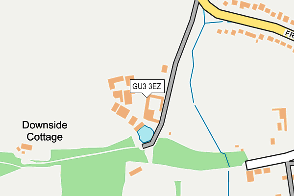
GU3 3EZ lies on Frog Grove Lane in Wood Street Village, Guildford. GU3 3EZ is located in the Worplesdon electoral ward, within the local authority district of Guildford and the English Parliamentary constituency of Guildford. The Sub Integrated Care Board (ICB) Location is NHS Surrey Heartlands ICB - 92A and the police force is Surrey. This postcode has been in use since September 1991.


GetTheData
Source: OS OpenMap – Local (Ordnance Survey)
Source: OS VectorMap District (Ordnance Survey)
Licence: Open Government Licence (requires attribution)
| Easting | 494804 |
| Northing | 151053 |
| Latitude | 51.250776 |
| Longitude | -0.642990 |
GetTheData
Source: Open Postcode Geo
Licence: Open Government Licence
| Street | Frog Grove Lane |
| Locality | Wood Street Village |
| Town/City | Guildford |
| Country | England |
| Postcode District | GU3 |
➜ See where GU3 is on a map ➜ Where is Wood Street Village? | |
GetTheData
Source: Land Registry Price Paid Data
Licence: Open Government Licence
Elevation or altitude of GU3 3EZ as distance above sea level:
| Metres | Feet | |
|---|---|---|
| Elevation | 50m | 164ft |
Elevation is measured from the approximate centre of the postcode, to the nearest point on an OS contour line from OS Terrain 50, which has contour spacing of ten vertical metres.
➜ How high above sea level am I? Find the elevation of your current position using your device's GPS.
GetTheData
Source: Open Postcode Elevation
Licence: Open Government Licence
| Ward | Worplesdon |
| Constituency | Guildford |
GetTheData
Source: ONS Postcode Database
Licence: Open Government Licence
| Sandy Lane (Frog Grove Lane) | Wood Street | 268m |
| Sandy Lane (Frog Grove Lane) | Wood Street | 288m |
| Braidwood (Frog Grove Lane) | Wood Street | 396m |
| Braidwood (Frog Grove Lane) | Wood Street | 430m |
| Wood Street Green | Wood Street | 546m |
| Wanborough Station | 1.9km |
| Guildford Station | 4.6km |
| Ash Station | 4.9km |
GetTheData
Source: NaPTAN
Licence: Open Government Licence
| Percentage of properties with Next Generation Access | 100.0% |
| Percentage of properties with Superfast Broadband | 0.0% |
| Percentage of properties with Ultrafast Broadband | 0.0% |
| Percentage of properties with Full Fibre Broadband | 0.0% |
Superfast Broadband is between 30Mbps and 300Mbps
Ultrafast Broadband is > 300Mbps
| Percentage of properties unable to receive 2Mbps | 0.0% |
| Percentage of properties unable to receive 5Mbps | 0.0% |
| Percentage of properties unable to receive 10Mbps | 0.0% |
| Percentage of properties unable to receive 30Mbps | 100.0% |
GetTheData
Source: Ofcom
Licence: Ofcom Terms of Use (requires attribution)
GetTheData
Source: ONS Postcode Database
Licence: Open Government Licence


➜ Get more ratings from the Food Standards Agency
GetTheData
Source: Food Standards Agency
Licence: FSA terms & conditions
| Last Collection | |||
|---|---|---|---|
| Location | Mon-Fri | Sat | Distance |
| Little Inholms | 17:30 | 08:15 | 498m |
| Frog Grove | 17:30 | 08:00 | 874m |
| Wood Street Post Office | 17:45 | 11:30 | 1,067m |
GetTheData
Source: Dracos
Licence: Creative Commons Attribution-ShareAlike
The below table lists the International Territorial Level (ITL) codes (formerly Nomenclature of Territorial Units for Statistics (NUTS) codes) and Local Administrative Units (LAU) codes for GU3 3EZ:
| ITL 1 Code | Name |
|---|---|
| TLJ | South East (England) |
| ITL 2 Code | Name |
| TLJ2 | Surrey, East and West Sussex |
| ITL 3 Code | Name |
| TLJ25 | West Surrey |
| LAU 1 Code | Name |
| E07000209 | Guildford |
GetTheData
Source: ONS Postcode Directory
Licence: Open Government Licence
The below table lists the Census Output Area (OA), Lower Layer Super Output Area (LSOA), and Middle Layer Super Output Area (MSOA) for GU3 3EZ:
| Code | Name | |
|---|---|---|
| OA | E00155588 | |
| LSOA | E01030503 | Guildford 005E |
| MSOA | E02006348 | Guildford 005 |
GetTheData
Source: ONS Postcode Directory
Licence: Open Government Licence
| GU3 3EY | Frog Grove Lane | 317m |
| GU3 3EX | Frog Grove Lane | 333m |
| GU3 3EA | White Hart Lane | 337m |
| GU3 3DZ | White Hart Lane | 404m |
| GU3 3DY | Wood Street Green | 491m |
| GU3 3HA | Frog Grove Lane | 497m |
| GU3 3EU | Wood Street Green | 578m |
| GU3 3DX | Holly Cottages | 606m |
| GU3 3DU | Wood Street Green | 677m |
| GU3 3DT | Pound Lane | 884m |
GetTheData
Source: Open Postcode Geo; Land Registry Price Paid Data
Licence: Open Government Licence