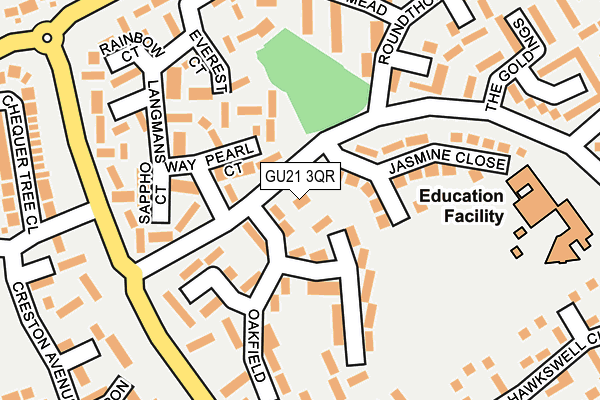
GU21 3QR lies on Kirkland Avenue in Woking. GU21 3QR is located in the Goldsworth Park electoral ward, within the local authority district of Woking and the English Parliamentary constituency of Woking. The Sub Integrated Care Board (ICB) Location is NHS Surrey Heartlands ICB - 92A and the police force is Surrey. This postcode has been in use since January 1980.


GetTheData
Source: OS OpenMap – Local (Ordnance Survey)
Source: OS VectorMap District (Ordnance Survey)
Licence: Open Government Licence (requires attribution)
| Easting | 497485 |
| Northing | 159108 |
| Latitude | 51.322732 |
| Longitude | -0.602392 |
GetTheData
Source: Open Postcode Geo
Licence: Open Government Licence
| Street | Kirkland Avenue |
| Town/City | Woking |
| Country | England |
| Postcode District | GU21 |
➜ See where GU21 is on a map ➜ Where is Woking? | |
GetTheData
Source: Land Registry Price Paid Data
Licence: Open Government Licence
Elevation or altitude of GU21 3QR as distance above sea level:
| Metres | Feet | |
|---|---|---|
| Elevation | 30m | 98ft |
Elevation is measured from the approximate centre of the postcode, to the nearest point on an OS contour line from OS Terrain 50, which has contour spacing of ten vertical metres.
➜ How high above sea level am I? Find the elevation of your current position using your device's GPS.
GetTheData
Source: Open Postcode Elevation
Licence: Open Government Licence
| Ward | Goldsworth Park |
| Constituency | Woking |
GetTheData
Source: ONS Postcode Database
Licence: Open Government Licence
| Jasmine Close (Kirkland Avenue) | Goldsworth Park | 77m |
| Jasmine Close (Kirkland Avenue) | Goldsworth Park | 78m |
| Langmans Way (Kirkland Avenue) | Goldsworth Park | 122m |
| Langmans Way (Kirkland Avenue) | Goldsworth Park | 126m |
| Knapwood House (Littlewick Road) | Goldsworth Park | 272m |
| Brookwood Station | 3.1km |
| Woking Station | 3.2km |
| Worplesdon Station | 4km |
GetTheData
Source: NaPTAN
Licence: Open Government Licence
| Percentage of properties with Next Generation Access | 100.0% |
| Percentage of properties with Superfast Broadband | 100.0% |
| Percentage of properties with Ultrafast Broadband | 100.0% |
| Percentage of properties with Full Fibre Broadband | 0.0% |
Superfast Broadband is between 30Mbps and 300Mbps
Ultrafast Broadband is > 300Mbps
| Percentage of properties unable to receive 2Mbps | 0.0% |
| Percentage of properties unable to receive 5Mbps | 0.0% |
| Percentage of properties unable to receive 10Mbps | 0.0% |
| Percentage of properties unable to receive 30Mbps | 0.0% |
GetTheData
Source: Ofcom
Licence: Ofcom Terms of Use (requires attribution)
GetTheData
Source: ONS Postcode Database
Licence: Open Government Licence


➜ Get more ratings from the Food Standards Agency
GetTheData
Source: Food Standards Agency
Licence: FSA terms & conditions
| Last Collection | |||
|---|---|---|---|
| Location | Mon-Fri | Sat | Distance |
| Kirkland Avenue | 16:45 | 12:00 | 144m |
| Anchor Hill | 16:45 | 09:00 | 673m |
| Denton Way | 17:15 | 12:00 | 732m |
GetTheData
Source: Dracos
Licence: Creative Commons Attribution-ShareAlike
The below table lists the International Territorial Level (ITL) codes (formerly Nomenclature of Territorial Units for Statistics (NUTS) codes) and Local Administrative Units (LAU) codes for GU21 3QR:
| ITL 1 Code | Name |
|---|---|
| TLJ | South East (England) |
| ITL 2 Code | Name |
| TLJ2 | Surrey, East and West Sussex |
| ITL 3 Code | Name |
| TLJ25 | West Surrey |
| LAU 1 Code | Name |
| E07000217 | Woking |
GetTheData
Source: ONS Postcode Directory
Licence: Open Government Licence
The below table lists the Census Output Area (OA), Lower Layer Super Output Area (LSOA), and Middle Layer Super Output Area (MSOA) for GU21 3QR:
| Code | Name | |
|---|---|---|
| OA | E00157812 | |
| LSOA | E01030957 | Woking 005E |
| MSOA | E02006460 | Woking 005 |
GetTheData
Source: ONS Postcode Directory
Licence: Open Government Licence
| GU21 3QZ | Pearl Court | 69m |
| GU21 3QS | Oakfield | 114m |
| GU21 3RQ | Jasmine Close | 120m |
| GU21 3RA | Sappho Court | 123m |
| GU21 3QU | Oakfield | 126m |
| GU21 3RH | Everest Court | 132m |
| GU21 3RJ | Queendale Court | 163m |
| GU21 3QY | Langmans Way | 164m |
| GU21 3QT | Oakfield | 166m |
| GU21 3RB | Goldfort Walk | 188m |
GetTheData
Source: Open Postcode Geo; Land Registry Price Paid Data
Licence: Open Government Licence