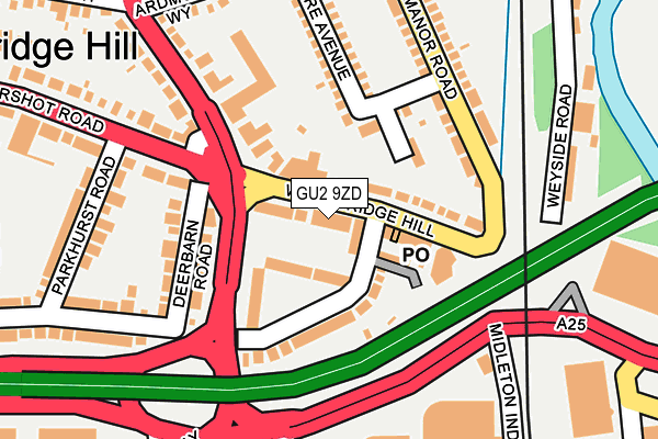
GU2 9ZD is located in the Stoughton South electoral ward, within the local authority district of Guildford and the English Parliamentary constituency of Guildford. The Sub Integrated Care Board (ICB) Location is NHS Surrey Heartlands ICB - 92A and the police force is Surrey. This postcode has been in use since June 2000.


GetTheData
Source: OS OpenMap – Local (Ordnance Survey)
Source: OS VectorMap District (Ordnance Survey)
Licence: Open Government Licence (requires attribution)
| Easting | 498732 |
| Northing | 150921 |
| Latitude | 51.248924 |
| Longitude | -0.586763 |
GetTheData
Source: Open Postcode Geo
Licence: Open Government Licence
| Country | England |
| Postcode District | GU2 |
➜ See where GU2 is on a map ➜ Where is Guildford? | |
GetTheData
Source: Land Registry Price Paid Data
Licence: Open Government Licence
Elevation or altitude of GU2 9ZD as distance above sea level:
| Metres | Feet | |
|---|---|---|
| Elevation | 40m | 131ft |
Elevation is measured from the approximate centre of the postcode, to the nearest point on an OS contour line from OS Terrain 50, which has contour spacing of ten vertical metres.
➜ How high above sea level am I? Find the elevation of your current position using your device's GPS.
GetTheData
Source: Open Postcode Elevation
Licence: Open Government Licence
| Ward | Stoughton South |
| Constituency | Guildford |
GetTheData
Source: ONS Postcode Database
Licence: Open Government Licence
| Weston Road (Woodbridge Hill) | Woodbridge Hill | 25m |
| Weston Road (Woodbridge Hill) | Woodbridge Hill | 29m |
| Woodbridge Hill (Worplesdon Road) | Woodbridge Hill | 160m |
| Woodbridge Hill (Worplesdon Road) | Woodbridge Hill | 168m |
| Woodbridge Hill (Aldershot Road) | Woodbridge Hill | 185m |
| Guildford Station | 1.4km |
| London Road (Guildford) Station | 1.8km |
| Shalford (Surrey) Station | 4.1km |
GetTheData
Source: NaPTAN
Licence: Open Government Licence
GetTheData
Source: ONS Postcode Database
Licence: Open Government Licence


➜ Get more ratings from the Food Standards Agency
GetTheData
Source: Food Standards Agency
Licence: FSA terms & conditions
| Last Collection | |||
|---|---|---|---|
| Location | Mon-Fri | Sat | Distance |
| Woodbridge Hill Post Office | 17:30 | 12:15 | 68m |
| Manor Road | 17:30 | 12:15 | 301m |
| Weston Road | 16:00 | 11:45 | 343m |
GetTheData
Source: Dracos
Licence: Creative Commons Attribution-ShareAlike
The below table lists the International Territorial Level (ITL) codes (formerly Nomenclature of Territorial Units for Statistics (NUTS) codes) and Local Administrative Units (LAU) codes for GU2 9ZD:
| ITL 1 Code | Name |
|---|---|
| TLJ | South East (England) |
| ITL 2 Code | Name |
| TLJ2 | Surrey, East and West Sussex |
| ITL 3 Code | Name |
| TLJ25 | West Surrey |
| LAU 1 Code | Name |
| E07000209 | Guildford |
GetTheData
Source: ONS Postcode Directory
Licence: Open Government Licence
The below table lists the Census Output Area (OA), Lower Layer Super Output Area (LSOA), and Middle Layer Super Output Area (MSOA) for GU2 9ZD:
| Code | Name | |
|---|---|---|
| OA | E00155515 | |
| LSOA | E01030487 | Guildford 006B |
| MSOA | E02006349 | Guildford 006 |
GetTheData
Source: ONS Postcode Directory
Licence: Open Government Licence
| GU2 9AD | Woodbridge Hill | 12m |
| GU2 9AB | Woodbridge Hill | 44m |
| GU2 8AX | Caxton Gardens | 59m |
| GU2 9AA | Woodbridge Hill | 72m |
| GU2 9ZZ | Heather Close | 97m |
| GU2 8AU | Weston Road | 98m |
| GU2 8AT | Deerbarn Road | 151m |
| GU2 9SH | Worplesdon Road | 159m |
| GU2 9UR | Francis Court | 164m |
| GU2 9NE | Manor Road | 187m |
GetTheData
Source: Open Postcode Geo; Land Registry Price Paid Data
Licence: Open Government Licence