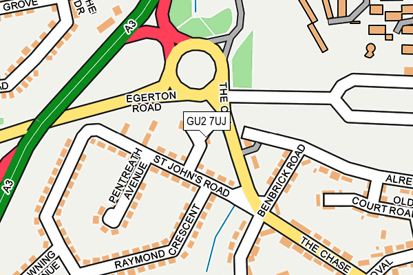
GU2 7UJ lies on St Johns Close in Guildford. GU2 7UJ is located in the Onslow electoral ward, within the local authority district of Guildford and the English Parliamentary constituency of Guildford. The Sub Integrated Care Board (ICB) Location is NHS Surrey Heartlands ICB - 92A and the police force is Surrey. This postcode has been in use since June 2000.


GetTheData
Source: OS OpenMap – Local (Ordnance Survey)
Source: OS VectorMap District (Ordnance Survey)
Licence: Open Government Licence (requires attribution)
| Easting | 498108 |
| Northing | 149993 |
| Latitude | 51.240690 |
| Longitude | -0.595954 |
GetTheData
Source: Open Postcode Geo
Licence: Open Government Licence
| Street | St Johns Close |
| Town/City | Guildford |
| Country | England |
| Postcode District | GU2 |
➜ See where GU2 is on a map ➜ Where is Guildford? | |
GetTheData
Source: Land Registry Price Paid Data
Licence: Open Government Licence
Elevation or altitude of GU2 7UJ as distance above sea level:
| Metres | Feet | |
|---|---|---|
| Elevation | 60m | 197ft |
Elevation is measured from the approximate centre of the postcode, to the nearest point on an OS contour line from OS Terrain 50, which has contour spacing of ten vertical metres.
➜ How high above sea level am I? Find the elevation of your current position using your device's GPS.
GetTheData
Source: Open Postcode Elevation
Licence: Open Government Licence
| Ward | Onslow |
| Constituency | Guildford |
GetTheData
Source: ONS Postcode Database
Licence: Open Government Licence
| The Chase | Dennisville | 50m |
| The Chase | Dennisville | 54m |
| School Of Acting (Perimeter Road) | Guildford | 245m |
| Raymond Crescent | Dennisville | 272m |
| The Oval (The Chase) | Dennisville | 281m |
| Guildford Station | 1.2km |
| London Road (Guildford) Station | 2.2km |
| Shalford (Surrey) Station | 3.6km |
GetTheData
Source: NaPTAN
Licence: Open Government Licence
| Percentage of properties with Next Generation Access | 100.0% |
| Percentage of properties with Superfast Broadband | 100.0% |
| Percentage of properties with Ultrafast Broadband | 100.0% |
| Percentage of properties with Full Fibre Broadband | 0.0% |
Superfast Broadband is between 30Mbps and 300Mbps
Ultrafast Broadband is > 300Mbps
| Percentage of properties unable to receive 2Mbps | 0.0% |
| Percentage of properties unable to receive 5Mbps | 0.0% |
| Percentage of properties unable to receive 10Mbps | 0.0% |
| Percentage of properties unable to receive 30Mbps | 0.0% |
GetTheData
Source: Ofcom
Licence: Ofcom Terms of Use (requires attribution)
GetTheData
Source: ONS Postcode Database
Licence: Open Government Licence


➜ Get more ratings from the Food Standards Agency
GetTheData
Source: Food Standards Agency
Licence: FSA terms & conditions
| Last Collection | |||
|---|---|---|---|
| Location | Mon-Fri | Sat | Distance |
| St Johns Road | 16:45 | 12:00 | 135m |
| Ashenden Road | 17:30 | 12:15 | 279m |
| West Meads | 16:45 | 12:00 | 279m |
GetTheData
Source: Dracos
Licence: Creative Commons Attribution-ShareAlike
The below table lists the International Territorial Level (ITL) codes (formerly Nomenclature of Territorial Units for Statistics (NUTS) codes) and Local Administrative Units (LAU) codes for GU2 7UJ:
| ITL 1 Code | Name |
|---|---|
| TLJ | South East (England) |
| ITL 2 Code | Name |
| TLJ2 | Surrey, East and West Sussex |
| ITL 3 Code | Name |
| TLJ25 | West Surrey |
| LAU 1 Code | Name |
| E07000209 | Guildford |
GetTheData
Source: ONS Postcode Directory
Licence: Open Government Licence
The below table lists the Census Output Area (OA), Lower Layer Super Output Area (LSOA), and Middle Layer Super Output Area (MSOA) for GU2 7UJ:
| Code | Name | |
|---|---|---|
| OA | E00155410 | |
| LSOA | E01030470 | Guildford 012A |
| MSOA | E02006355 | Guildford 012 |
GetTheData
Source: ONS Postcode Directory
Licence: Open Government Licence
| GU2 7UH | St Johns Road | 54m |
| GU2 7UL | The Chase | 63m |
| GU2 7UQ | St Johns Road | 92m |
| GU2 7UD | Benbrick Road | 112m |
| GU2 7TA | Pentreath Avenue | 166m |
| GU2 7SJ | Elmside | 188m |
| GU2 7UE | Alresford Road | 190m |
| GU2 7SX | Raymond Crescent | 196m |
| GU2 7SU | Raymond Crescent | 206m |
| GU2 7UY | The Drive | 220m |
GetTheData
Source: Open Postcode Geo; Land Registry Price Paid Data
Licence: Open Government Licence