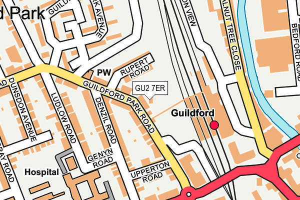
GU2 7ER is located in the Onslow electoral ward, within the local authority district of Guildford and the English Parliamentary constituency of Guildford. The Sub Integrated Care Board (ICB) Location is NHS Surrey Heartlands ICB - 92A and the police force is Surrey. This postcode has been in use since June 2000.


GetTheData
Source: OS OpenMap – Local (Ordnance Survey)
Source: OS VectorMap District (Ordnance Survey)
Licence: Open Government Licence (requires attribution)
| Easting | 499048 |
| Northing | 149634 |
| Latitude | 51.237300 |
| Longitude | -0.582592 |
GetTheData
Source: Open Postcode Geo
Licence: Open Government Licence
| Country | England |
| Postcode District | GU2 |
➜ See where GU2 is on a map ➜ Where is Guildford? | |
GetTheData
Source: Land Registry Price Paid Data
Licence: Open Government Licence
Elevation or altitude of GU2 7ER as distance above sea level:
| Metres | Feet | |
|---|---|---|
| Elevation | 40m | 131ft |
Elevation is measured from the approximate centre of the postcode, to the nearest point on an OS contour line from OS Terrain 50, which has contour spacing of ten vertical metres.
➜ How high above sea level am I? Find the elevation of your current position using your device's GPS.
GetTheData
Source: Open Postcode Elevation
Licence: Open Government Licence
| Ward | Onslow |
| Constituency | Guildford |
GetTheData
Source: ONS Postcode Database
Licence: Open Government Licence
| Guildford Station (Guildford Park Road) | Guildford | 38m |
| Guildford Station (Guildford Park Road) | Guildford | 42m |
| Guildford Park South (Guildford Park And Ride Car Park) | Guildford Park | 133m |
| Guildford Park Avenue (Guildford Park Road) | Guildford Park | 175m |
| Guildford Park Avenue (Guildford Park Road) | Guildford Park | 204m |
| Guildford Station | 0.2km |
| London Road (Guildford) Station | 1.3km |
| Shalford (Surrey) Station | 2.8km |
GetTheData
Source: NaPTAN
Licence: Open Government Licence
GetTheData
Source: ONS Postcode Database
Licence: Open Government Licence


➜ Get more ratings from the Food Standards Agency
GetTheData
Source: Food Standards Agency
Licence: FSA terms & conditions
| Last Collection | |||
|---|---|---|---|
| Location | Mon-Fri | Sat | Distance |
| Guildford Railway Station | 18:45 | 12:00 | 169m |
| Bottom Of Farnham Road | 17:30 | 11:45 | 220m |
| Guildford Park Post Office | 17:30 | 11:45 | 324m |
GetTheData
Source: Dracos
Licence: Creative Commons Attribution-ShareAlike
The below table lists the International Territorial Level (ITL) codes (formerly Nomenclature of Territorial Units for Statistics (NUTS) codes) and Local Administrative Units (LAU) codes for GU2 7ER:
| ITL 1 Code | Name |
|---|---|
| TLJ | South East (England) |
| ITL 2 Code | Name |
| TLJ2 | Surrey, East and West Sussex |
| ITL 3 Code | Name |
| TLJ25 | West Surrey |
| LAU 1 Code | Name |
| E07000209 | Guildford |
GetTheData
Source: ONS Postcode Directory
Licence: Open Government Licence
The below table lists the Census Output Area (OA), Lower Layer Super Output Area (LSOA), and Middle Layer Super Output Area (MSOA) for GU2 7ER:
| Code | Name | |
|---|---|---|
| OA | E00155303 | |
| LSOA | E01030452 | Guildford 015A |
| MSOA | E02006358 | Guildford 015 |
GetTheData
Source: ONS Postcode Directory
Licence: Open Government Licence
| GU2 7ND | Guildford Park Road | 47m |
| GU2 7NE | Rupert Road | 86m |
| GU2 7NA | Guildford Park Road | 103m |
| GU2 7NG | Denzil Road | 115m |
| GU2 7NB | Upperton Road | 126m |
| GU2 7NQ | Denzil Road | 130m |
| GU2 7NF | Guildford Park Road | 150m |
| GU2 7NR | Ludlow Road | 160m |
| GU2 7NS | Genyn Road | 164m |
| GU2 7NJ | Guildford Park Avenue | 166m |
GetTheData
Source: Open Postcode Geo; Land Registry Price Paid Data
Licence: Open Government Licence