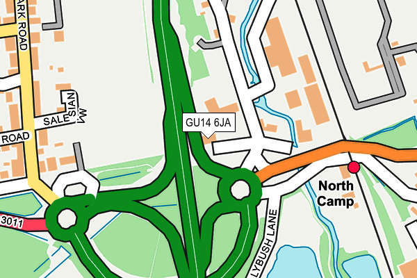
GU14 6JA is located in the St Mark's electoral ward, within the local authority district of Rushmoor and the English Parliamentary constituency of Aldershot. The Sub Integrated Care Board (ICB) Location is NHS Frimley ICB - D4U1Y and the police force is Hampshire. This postcode has been in use since January 1980.


GetTheData
Source: OS OpenMap – Local (Ordnance Survey)
Source: OS VectorMap District (Ordnance Survey)
Licence: Open Government Licence (requires attribution)
| Easting | 488406 |
| Northing | 153773 |
| Latitude | 51.276255 |
| Longitude | -0.733967 |
GetTheData
Source: Open Postcode Geo
Licence: Open Government Licence
| Country | England |
| Postcode District | GU14 |
➜ See where GU14 is on a map ➜ Where is Ash Vale? | |
GetTheData
Source: Land Registry Price Paid Data
Licence: Open Government Licence
Elevation or altitude of GU14 6JA as distance above sea level:
| Metres | Feet | |
|---|---|---|
| Elevation | 70m | 230ft |
Elevation is measured from the approximate centre of the postcode, to the nearest point on an OS contour line from OS Terrain 50, which has contour spacing of ten vertical metres.
➜ How high above sea level am I? Find the elevation of your current position using your device's GPS.
GetTheData
Source: Open Postcode Elevation
Licence: Open Government Licence
| Ward | St Mark's |
| Constituency | Aldershot |
GetTheData
Source: ONS Postcode Database
Licence: Open Government Licence
| North Camp Railway Station (A3011) | North Camp | 113m |
| North Camp Railway Station (Station Approach) | Ash Vale | 150m |
| North Camp Railway Station (Station Approach) | Ash Vale | 151m |
| Park Road (Queens Road) | North Camp | 335m |
| Park Road (Queens Road) | North Camp | 339m |
| North Camp Station | 0.2km |
| Ash Vale Station | 1km |
| Farnborough (Main) Station | 2.7km |
GetTheData
Source: NaPTAN
Licence: Open Government Licence
GetTheData
Source: ONS Postcode Database
Licence: Open Government Licence


➜ Get more ratings from the Food Standards Agency
GetTheData
Source: Food Standards Agency
Licence: FSA terms & conditions
| Last Collection | |||
|---|---|---|---|
| Location | Mon-Fri | Sat | Distance |
| Park Road | 17:45 | 11:45 | 304m |
| Lynchford Road | 16:45 | 11:45 | 522m |
| Avondale Estate | 17:45 | 11:15 | 715m |
GetTheData
Source: Dracos
Licence: Creative Commons Attribution-ShareAlike
The below table lists the International Territorial Level (ITL) codes (formerly Nomenclature of Territorial Units for Statistics (NUTS) codes) and Local Administrative Units (LAU) codes for GU14 6JA:
| ITL 1 Code | Name |
|---|---|
| TLJ | South East (England) |
| ITL 2 Code | Name |
| TLJ3 | Hampshire and Isle of Wight |
| ITL 3 Code | Name |
| TLJ37 | North Hampshire |
| LAU 1 Code | Name |
| E07000092 | Rushmoor |
GetTheData
Source: ONS Postcode Directory
Licence: Open Government Licence
The below table lists the Census Output Area (OA), Lower Layer Super Output Area (LSOA), and Middle Layer Super Output Area (MSOA) for GU14 6JA:
| Code | Name | |
|---|---|---|
| OA | E00117560 | |
| LSOA | E01023139 | Rushmoor 007F |
| MSOA | E02004808 | Rushmoor 007 |
GetTheData
Source: ONS Postcode Directory
Licence: Open Government Licence
| GU14 6HZ | Lynchford Road | 206m |
| GU14 6JQ | Salesian View | 210m |
| GU14 6HY | Lynchford Road | 245m |
| GU14 6JG | Park Road | 271m |
| GU14 6LQ | Park Road | 272m |
| GU14 6LG | Park Road | 295m |
| GU14 6HX | Lynchford Road | 296m |
| GU14 6LH | Park Road | 325m |
| GU14 6HU | Lime Tree Walk | 339m |
| GU14 6LE | Queens Road | 355m |
GetTheData
Source: Open Postcode Geo; Land Registry Price Paid Data
Licence: Open Government Licence