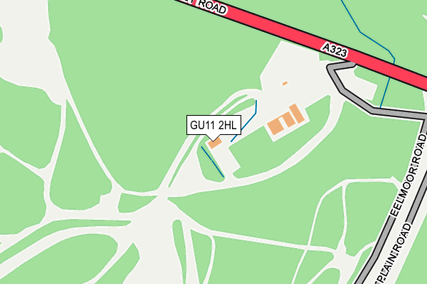
GU11 2HL is located in the Wellington electoral ward, within the local authority district of Rushmoor and the English Parliamentary constituency of Aldershot. The Sub Integrated Care Board (ICB) Location is NHS Frimley ICB - D4U1Y and the police force is Hampshire. This postcode has been in use since June 2000.


GetTheData
Source: OS OpenMap – Local (Ordnance Survey)
Source: OS VectorMap District (Ordnance Survey)
Licence: Open Government Licence (requires attribution)
| Easting | 484580 |
| Northing | 152506 |
| Latitude | 51.265443 |
| Longitude | -0.789086 |
GetTheData
Source: Open Postcode Geo
Licence: Open Government Licence
| Country | England |
| Postcode District | GU11 |
➜ See where GU11 is on a map | |
GetTheData
Source: Land Registry Price Paid Data
Licence: Open Government Licence
Elevation or altitude of GU11 2HL as distance above sea level:
| Metres | Feet | |
|---|---|---|
| Elevation | 90m | 295ft |
Elevation is measured from the approximate centre of the postcode, to the nearest point on an OS contour line from OS Terrain 50, which has contour spacing of ten vertical metres.
➜ How high above sea level am I? Find the elevation of your current position using your device's GPS.
GetTheData
Source: Open Postcode Elevation
Licence: Open Government Licence
| Ward | Wellington |
| Constituency | Aldershot |
GetTheData
Source: ONS Postcode Database
Licence: Open Government Licence
| Eelmoor Car Park - Temporary (Eelmoor Plain Road) | Farnborough | 315m |
| Gate I - Airport - Temporary (Eelmoor Bridge) | Farnborough | 390m |
| Rushmoor Arena - Temporary (Arena Lane) | Farnborough | 954m |
| Gate F Airport - Temporary (Aerospace Boulevard) | Farnborough | 1,446m |
| Hertford House | Watts Common | 1,686m |
| Aldershot Station | 2.9km |
| Fleet Station | 4km |
| Farnborough (Main) Station | 4.2km |
GetTheData
Source: NaPTAN
Licence: Open Government Licence
GetTheData
Source: ONS Postcode Database
Licence: Open Government Licence


➜ Get more ratings from the Food Standards Agency
GetTheData
Source: Food Standards Agency
Licence: FSA terms & conditions
| Last Collection | |||
|---|---|---|---|
| Location | Mon-Fri | Sat | Distance |
| Cody Gate | 18:15 | 11:00 | 1,677m |
| Salamanca Park | 18:00 | 11:45 | 1,741m |
| Tesco Store | 18:30 | 12:00 | 1,923m |
GetTheData
Source: Dracos
Licence: Creative Commons Attribution-ShareAlike
The below table lists the International Territorial Level (ITL) codes (formerly Nomenclature of Territorial Units for Statistics (NUTS) codes) and Local Administrative Units (LAU) codes for GU11 2HL:
| ITL 1 Code | Name |
|---|---|
| TLJ | South East (England) |
| ITL 2 Code | Name |
| TLJ3 | Hampshire and Isle of Wight |
| ITL 3 Code | Name |
| TLJ37 | North Hampshire |
| LAU 1 Code | Name |
| E07000092 | Rushmoor |
GetTheData
Source: ONS Postcode Directory
Licence: Open Government Licence
The below table lists the Census Output Area (OA), Lower Layer Super Output Area (LSOA), and Middle Layer Super Output Area (MSOA) for GU11 2HL:
| Code | Name | |
|---|---|---|
| OA | E00117574 | |
| LSOA | E01023143 | Rushmoor 008C |
| MSOA | E02004809 | Rushmoor 008 |
GetTheData
Source: ONS Postcode Directory
Licence: Open Government Licence
| GU11 2ET | Fleet Road | 1348m |
| GU14 6UU | Hercules Way | 1551m |
| GU11 2HE | Shoe Lane | 1555m |
| GU14 6XR | Woodside Road | 1558m |
| GU11 2HG | Vine Close | 1767m |
| GU14 0LL | Old Ively Road | 1811m |
| GU14 6XP | Lakeside Road | 1840m |
| GU14 6XW | Aerospace Boulevard | 1890m |
| GU14 6XN | Gladiator Way | 1906m |
| GU11 1YH | Beaumont Grove | 1910m |
GetTheData
Source: Open Postcode Geo; Land Registry Price Paid Data
Licence: Open Government Licence