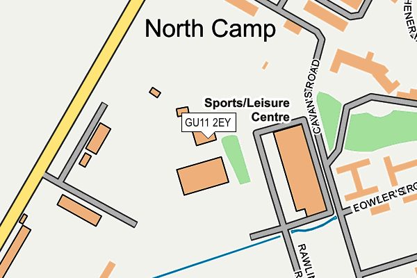
GU11 2EY is located in the St Mark's electoral ward, within the local authority district of Rushmoor and the English Parliamentary constituency of Aldershot. The Sub Integrated Care Board (ICB) Location is NHS Frimley ICB - D4U1Y and the police force is Hampshire. This postcode has been in use since March 2010.


GetTheData
Source: OS OpenMap – Local (Ordnance Survey)
Source: OS VectorMap District (Ordnance Survey)
Licence: Open Government Licence (requires attribution)
| Easting | 487218 |
| Northing | 152675 |
| Latitude | 51.266565 |
| Longitude | -0.751244 |
GetTheData
Source: Open Postcode Geo
Licence: Open Government Licence
| Country | England |
| Postcode District | GU11 |
➜ See where GU11 is on a map ➜ Where is Farnborough? | |
GetTheData
Source: Land Registry Price Paid Data
Licence: Open Government Licence
Elevation or altitude of GU11 2EY as distance above sea level:
| Metres | Feet | |
|---|---|---|
| Elevation | 80m | 262ft |
Elevation is measured from the approximate centre of the postcode, to the nearest point on an OS contour line from OS Terrain 50, which has contour spacing of ten vertical metres.
➜ How high above sea level am I? Find the elevation of your current position using your device's GPS.
GetTheData
Source: Open Postcode Elevation
Licence: Open Government Licence
| Ward | St Mark's |
| Constituency | Aldershot |
GetTheData
Source: ONS Postcode Database
Licence: Open Government Licence
| Hammersley Road (Queen's Avenue) | Aldershot | 228m |
| Hammersley Road (Queen's Avenue) | Aldershot | 302m |
| Prince's Avenue (Queen's Avenue) | Montgomery Lines | 506m |
| Prince's Avenue (Queen's Avenue) | Montgomery Lines | 527m |
| Napier Gardens (Queen's Avenue) | North Camp | 575m |
| North Camp Station | 1.7km |
| Ash Vale Station | 2.2km |
| Aldershot Station | 2.3km |
GetTheData
Source: NaPTAN
Licence: Open Government Licence
GetTheData
Source: ONS Postcode Database
Licence: Open Government Licence


➜ Get more ratings from the Food Standards Agency
GetTheData
Source: Food Standards Agency
Licence: FSA terms & conditions
| Last Collection | |||
|---|---|---|---|
| Location | Mon-Fri | Sat | Distance |
| Rhine Barracks | 18:00 | 11:45 | 1,002m |
| Netley Street | 16:30 | 11:30 | 1,050m |
| Osborne Road | 16:30 | 11:15 | 1,095m |
GetTheData
Source: Dracos
Licence: Creative Commons Attribution-ShareAlike
The below table lists the International Territorial Level (ITL) codes (formerly Nomenclature of Territorial Units for Statistics (NUTS) codes) and Local Administrative Units (LAU) codes for GU11 2EY:
| ITL 1 Code | Name |
|---|---|
| TLJ | South East (England) |
| ITL 2 Code | Name |
| TLJ3 | Hampshire and Isle of Wight |
| ITL 3 Code | Name |
| TLJ37 | North Hampshire |
| LAU 1 Code | Name |
| E07000092 | Rushmoor |
GetTheData
Source: ONS Postcode Directory
Licence: Open Government Licence
The below table lists the Census Output Area (OA), Lower Layer Super Output Area (LSOA), and Middle Layer Super Output Area (MSOA) for GU11 2EY:
| Code | Name | |
|---|---|---|
| OA | E00117556 | |
| LSOA | E01023136 | Rushmoor 007C |
| MSOA | E02004808 | Rushmoor 007 |
GetTheData
Source: ONS Postcode Directory
Licence: Open Government Licence
| GU11 2LW | Dukes Park | 644m |
| GU14 6AR | Lynchford Road | 867m |
| GU11 2HG | Vine Close | 885m |
| GU14 6BA | Peel Court | 887m |
| GU14 6DA | Alexandra Road | 916m |
| GU14 6EJ | Lynchford Road | 932m |
| GU14 6FU | Kenley Place | 939m |
| GU14 6FX | Kenley Place | 941m |
| GU14 6AP | Osborne Road | 945m |
| GU14 6AJ | Winchester Street | 954m |
GetTheData
Source: Open Postcode Geo; Land Registry Price Paid Data
Licence: Open Government Licence