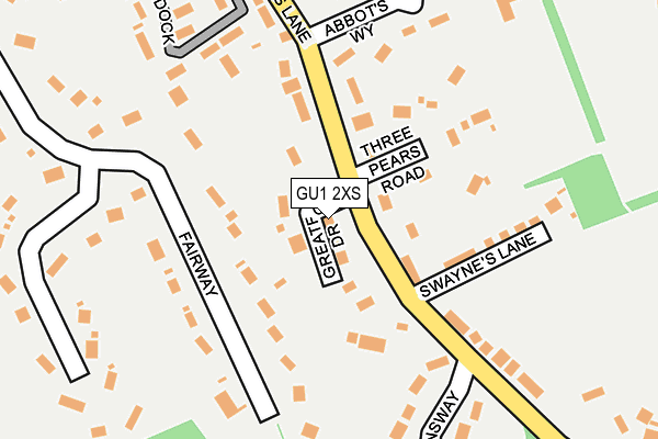
GU1 2XS lies on Greatford Drive in Guildford. GU1 2XS is located in the Merrow electoral ward, within the local authority district of Guildford and the English Parliamentary constituency of Guildford. The Sub Integrated Care Board (ICB) Location is NHS Surrey Heartlands ICB - 92A and the police force is Surrey. This postcode has been in use since January 1980.


GetTheData
Source: OS OpenMap – Local (Ordnance Survey)
Source: OS VectorMap District (Ordnance Survey)
Licence: Open Government Licence (requires attribution)
| Easting | 502951 |
| Northing | 150411 |
| Latitude | 51.243595 |
| Longitude | -0.526481 |
GetTheData
Source: Open Postcode Geo
Licence: Open Government Licence
| Street | Greatford Drive |
| Town/City | Guildford |
| Country | England |
| Postcode District | GU1 |
➜ See where GU1 is on a map ➜ Where is Guildford? | |
GetTheData
Source: Land Registry Price Paid Data
Licence: Open Government Licence
Elevation or altitude of GU1 2XS as distance above sea level:
| Metres | Feet | |
|---|---|---|
| Elevation | 90m | 295ft |
Elevation is measured from the approximate centre of the postcode, to the nearest point on an OS contour line from OS Terrain 50, which has contour spacing of ten vertical metres.
➜ How high above sea level am I? Find the elevation of your current position using your device's GPS.
GetTheData
Source: Open Postcode Elevation
Licence: Open Government Licence
| Ward | Merrow |
| Constituency | Guildford |
GetTheData
Source: ONS Postcode Database
Licence: Open Government Licence
2022 24 NOV £1,120,000 |
2, GREATFORD DRIVE, GUILDFORD, GU1 2XS 2009 24 AUG £625,000 |
LONGSHOT, GREATFORD DRIVE, GUILDFORD, GU1 2XS 2004 10 DEC £725,000 |
1996 10 JAN £222,500 |
GetTheData
Source: HM Land Registry Price Paid Data
Licence: Contains HM Land Registry data © Crown copyright and database right 2025. This data is licensed under the Open Government Licence v3.0.
| Church (Epsom Road) | Merrow | 324m |
| Church (Epsom Road) | Merrow | 332m |
| Levylsdene (Epsom Road) | Merrow | 429m |
| Wykeham Road (Bushy Hill Drive) | Merrow | 440m |
| Wykeham Road (Bushy Hill Drive) | Merrow | 476m |
| London Road (Guildford) Station | 2.7km |
| Clandon Station | 2.8km |
| Chilworth Station | 3.2km |
GetTheData
Source: NaPTAN
Licence: Open Government Licence
| Percentage of properties with Next Generation Access | 100.0% |
| Percentage of properties with Superfast Broadband | 100.0% |
| Percentage of properties with Ultrafast Broadband | 0.0% |
| Percentage of properties with Full Fibre Broadband | 0.0% |
Superfast Broadband is between 30Mbps and 300Mbps
Ultrafast Broadband is > 300Mbps
| Percentage of properties unable to receive 2Mbps | 0.0% |
| Percentage of properties unable to receive 5Mbps | 0.0% |
| Percentage of properties unable to receive 10Mbps | 0.0% |
| Percentage of properties unable to receive 30Mbps | 0.0% |
GetTheData
Source: Ofcom
Licence: Ofcom Terms of Use (requires attribution)
GetTheData
Source: ONS Postcode Database
Licence: Open Government Licence


➜ Get more ratings from the Food Standards Agency
GetTheData
Source: Food Standards Agency
Licence: FSA terms & conditions
| Last Collection | |||
|---|---|---|---|
| Location | Mon-Fri | Sat | Distance |
| Trodds Lane | 17:30 | 12:30 | 68m |
| Fairway | 17:45 | 11:45 | 209m |
| Merrow Post Office | 18:30 | 12:15 | 359m |
GetTheData
Source: Dracos
Licence: Creative Commons Attribution-ShareAlike
The below table lists the International Territorial Level (ITL) codes (formerly Nomenclature of Territorial Units for Statistics (NUTS) codes) and Local Administrative Units (LAU) codes for GU1 2XS:
| ITL 1 Code | Name |
|---|---|
| TLJ | South East (England) |
| ITL 2 Code | Name |
| TLJ2 | Surrey, East and West Sussex |
| ITL 3 Code | Name |
| TLJ25 | West Surrey |
| LAU 1 Code | Name |
| E07000209 | Guildford |
GetTheData
Source: ONS Postcode Directory
Licence: Open Government Licence
The below table lists the Census Output Area (OA), Lower Layer Super Output Area (LSOA), and Middle Layer Super Output Area (MSOA) for GU1 2XS:
| Code | Name | |
|---|---|---|
| OA | E00155383 | |
| LSOA | E01030461 | Guildford 011E |
| MSOA | E02006354 | Guildford 011 |
GetTheData
Source: ONS Postcode Directory
Licence: Open Government Licence
| GU1 2XT | Trodds Lane | 53m |
| GU1 2XR | Trodds Lane | 66m |
| GU1 2XQ | Fairway | 99m |
| GU1 2XU | Three Pears Road | 137m |
| GU1 2XX | Swaynes Lane | 146m |
| GU1 2XL | Fairway | 162m |
| GU1 2XP | Abbots Way | 187m |
| GU1 2YA | Downsway | 224m |
| GU1 2RQ | The Paddock | 232m |
| GU1 2XJ | Fairway | 241m |
GetTheData
Source: Open Postcode Geo; Land Registry Price Paid Data
Licence: Open Government Licence