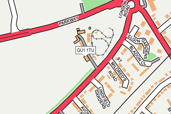
GU1 1TU is located in the Stoke electoral ward, within the local authority district of Guildford and the English Parliamentary constituency of Guildford. The Sub Integrated Care Board (ICB) Location is NHS Surrey Heartlands ICB - 92A and the police force is Surrey. This postcode has been in use since January 1980.


GetTheData
Source: OS OpenMap – Local (Ordnance Survey)
Source: OS VectorMap District (Ordnance Survey)
Licence: Open Government Licence (requires attribution)
| Easting | 500850 |
| Northing | 150821 |
| Latitude | 51.247651 |
| Longitude | -0.556433 |
GetTheData
Source: Open Postcode Geo
Licence: Open Government Licence
| Country | England |
| Postcode District | GU1 |
➜ See where GU1 is on a map ➜ Where is Guildford? | |
GetTheData
Source: Land Registry Price Paid Data
Licence: Open Government Licence
Elevation or altitude of GU1 1TU as distance above sea level:
| Metres | Feet | |
|---|---|---|
| Elevation | 50m | 164ft |
Elevation is measured from the approximate centre of the postcode, to the nearest point on an OS contour line from OS Terrain 50, which has contour spacing of ten vertical metres.
➜ How high above sea level am I? Find the elevation of your current position using your device's GPS.
GetTheData
Source: Open Postcode Elevation
Licence: Open Government Licence
| Ward | Stoke |
| Constituency | Guildford |
GetTheData
Source: ONS Postcode Database
Licence: Open Government Licence
| Avonmore Avenue (London Road) | Guildford | 107m |
| Elgin Gardens (London Road) | Guildford | 125m |
| Elgin Gardens (London Road) | Guildford | 173m |
| Avonmore Avenue (London Road) | Guildford | 209m |
| Spectrum Leisure Centre | Guildford | 273m |
| London Road (Guildford) Station | 1km |
| Guildford Station | 2.1km |
| Shalford (Surrey) Station | 3.8km |
GetTheData
Source: NaPTAN
Licence: Open Government Licence
GetTheData
Source: ONS Postcode Database
Licence: Open Government Licence


➜ Get more ratings from the Food Standards Agency
GetTheData
Source: Food Standards Agency
Licence: FSA terms & conditions
| Last Collection | |||
|---|---|---|---|
| Location | Mon-Fri | Sat | Distance |
| Boxgrove Road | 17:30 | 12:15 | 181m |
| Avonmore Avenue | 17:45 | 12:15 | 205m |
| Abbotswood | 17:00 | 11:45 | 422m |
GetTheData
Source: Dracos
Licence: Creative Commons Attribution-ShareAlike
The below table lists the International Territorial Level (ITL) codes (formerly Nomenclature of Territorial Units for Statistics (NUTS) codes) and Local Administrative Units (LAU) codes for GU1 1TU:
| ITL 1 Code | Name |
|---|---|
| TLJ | South East (England) |
| ITL 2 Code | Name |
| TLJ2 | Surrey, East and West Sussex |
| ITL 3 Code | Name |
| TLJ25 | West Surrey |
| LAU 1 Code | Name |
| E07000209 | Guildford |
GetTheData
Source: ONS Postcode Directory
Licence: Open Government Licence
The below table lists the Census Output Area (OA), Lower Layer Super Output Area (LSOA), and Middle Layer Super Output Area (MSOA) for GU1 1TU:
| Code | Name | |
|---|---|---|
| OA | E00155249 | |
| LSOA | E01030438 | Guildford 013A |
| MSOA | E02006356 | Guildford 013 |
GetTheData
Source: ONS Postcode Directory
Licence: Open Government Licence
| GU1 1UA | London Road | 132m |
| GU1 1TT | London Road | 145m |
| GU1 1TZ | London Road | 150m |
| GU1 1TS | Lindfield Gardens | 167m |
| GU1 1TX | St Mildreds Road | 178m |
| GU1 1TP | Lindfield Gardens | 190m |
| GU1 1TY | Bladon Close | 203m |
| GU1 1TW | Avonmore Avenue | 241m |
| GU1 1UB | Elgin Gardens | 242m |
| GU1 1TN | London Road | 255m |
GetTheData
Source: Open Postcode Geo; Land Registry Price Paid Data
Licence: Open Government Licence