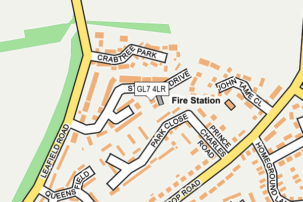
GL7 4LR lies on Warwick Close in Fairford. GL7 4LR is located in the Fairford North electoral ward, within the local authority district of Cotswold and the English Parliamentary constituency of The Cotswolds. The Sub Integrated Care Board (ICB) Location is NHS Gloucestershire ICB - 11M and the police force is Gloucestershire. This postcode has been in use since February 1990.


GetTheData
Source: OS OpenMap – Local (Ordnance Survey)
Source: OS VectorMap District (Ordnance Survey)
Licence: Open Government Licence (requires attribution)
| Easting | 415819 |
| Northing | 201516 |
| Latitude | 51.712157 |
| Longitude | -1.772444 |
GetTheData
Source: Open Postcode Geo
Licence: Open Government Licence
| Street | Warwick Close |
| Town/City | Fairford |
| Country | England |
| Postcode District | GL7 |
➜ See where GL7 is on a map ➜ Where is Fairford? | |
GetTheData
Source: Land Registry Price Paid Data
Licence: Open Government Licence
Elevation or altitude of GL7 4LR as distance above sea level:
| Metres | Feet | |
|---|---|---|
| Elevation | 90m | 295ft |
Elevation is measured from the approximate centre of the postcode, to the nearest point on an OS contour line from OS Terrain 50, which has contour spacing of ten vertical metres.
➜ How high above sea level am I? Find the elevation of your current position using your device's GPS.
GetTheData
Source: Open Postcode Elevation
Licence: Open Government Licence
| Ward | Fairford North |
| Constituency | The Cotswolds |
GetTheData
Source: ONS Postcode Database
Licence: Open Government Licence
2, WARWICK CLOSE, FAIRFORD, GL7 4LR 2023 28 APR £585,000 |
2016 24 MAR £389,950 |
2015 3 AUG £405,000 |
2004 20 MAY £320,000 |
1999 6 JUL £150,000 |
1997 31 JUL £118,500 |
GetTheData
Source: HM Land Registry Price Paid Data
Licence: Contains HM Land Registry data © Crown copyright and database right 2025. This data is licensed under the Open Government Licence v3.0.
| Fire Station (Hatherop Road) | Fairford | 204m |
| Fire Station (Hatherop Road) | Fairford | 206m |
| Churchill Place (Hatherop Road) | Fairford | 217m |
| Churchill Place (Hatherop Road) | Fairford | 232m |
| Demand Responsive Area | Fairford | 350m |
GetTheData
Source: NaPTAN
Licence: Open Government Licence
| Percentage of properties with Next Generation Access | 100.0% |
| Percentage of properties with Superfast Broadband | 100.0% |
| Percentage of properties with Ultrafast Broadband | 0.0% |
| Percentage of properties with Full Fibre Broadband | 0.0% |
Superfast Broadband is between 30Mbps and 300Mbps
Ultrafast Broadband is > 300Mbps
| Percentage of properties unable to receive 2Mbps | 0.0% |
| Percentage of properties unable to receive 5Mbps | 0.0% |
| Percentage of properties unable to receive 10Mbps | 0.0% |
| Percentage of properties unable to receive 30Mbps | 0.0% |
GetTheData
Source: Ofcom
Licence: Ofcom Terms of Use (requires attribution)
GetTheData
Source: ONS Postcode Database
Licence: Open Government Licence


➜ Get more ratings from the Food Standards Agency
GetTheData
Source: Food Standards Agency
Licence: FSA terms & conditions
| Last Collection | |||
|---|---|---|---|
| Location | Mon-Fri | Sat | Distance |
| Fairford Post Office | 17:15 | 12:00 | 789m |
| Eastleach P.o. | 16:30 | 10:15 | 5,538m |
GetTheData
Source: Dracos
Licence: Creative Commons Attribution-ShareAlike
The below table lists the International Territorial Level (ITL) codes (formerly Nomenclature of Territorial Units for Statistics (NUTS) codes) and Local Administrative Units (LAU) codes for GL7 4LR:
| ITL 1 Code | Name |
|---|---|
| TLK | South West (England) |
| ITL 2 Code | Name |
| TLK1 | Gloucestershire, Wiltshire and Bath/Bristol area |
| ITL 3 Code | Name |
| TLK13 | Gloucestershire CC |
| LAU 1 Code | Name |
| E07000079 | Cotswold |
GetTheData
Source: ONS Postcode Directory
Licence: Open Government Licence
The below table lists the Census Output Area (OA), Lower Layer Super Output Area (LSOA), and Middle Layer Super Output Area (MSOA) for GL7 4LR:
| Code | Name | |
|---|---|---|
| OA | E00112839 | |
| LSOA | E01022202 | Cotswold 009A |
| MSOA | E02004623 | Cotswold 009 |
GetTheData
Source: ONS Postcode Directory
Licence: Open Government Licence
| GL7 4LQ | St Marys Drive | 43m |
| GL7 4LP | Beauchamp Close | 60m |
| GL7 4LT | Crabtree Park | 88m |
| GL7 4LF | Park Close | 100m |
| GL7 4JY | Prince Charles Road | 120m |
| GL7 4LL | Leafield Road | 126m |
| GL7 4LN | Barker Place | 146m |
| GL7 4NP | John Tame Close | 170m |
| GL7 4JS | Hatherop Road | 177m |
| GL7 4JZ | Hatherop Road | 186m |
GetTheData
Source: Open Postcode Geo; Land Registry Price Paid Data
Licence: Open Government Licence