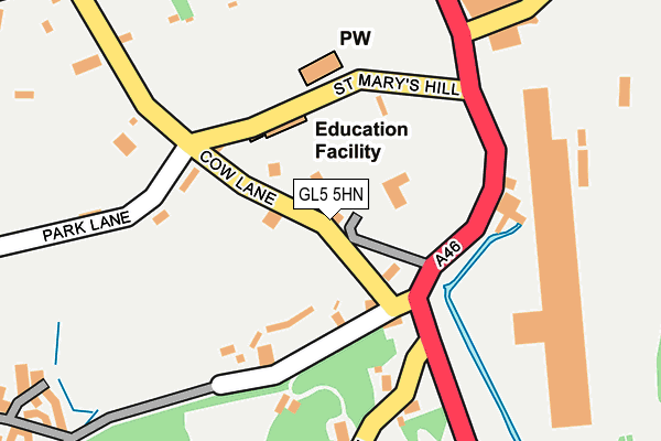
GL5 5HN lies on Cow Lane in Inchbrook, Stroud. GL5 5HN is located in the Amberley and Woodchester electoral ward, within the local authority district of Stroud and the English Parliamentary constituency of Stroud. The Sub Integrated Care Board (ICB) Location is NHS Gloucestershire ICB - 11M and the police force is Gloucestershire. This postcode has been in use since January 1980.


GetTheData
Source: OS OpenMap – Local (Ordnance Survey)
Source: OS VectorMap District (Ordnance Survey)
Licence: Open Government Licence (requires attribution)
| Easting | 384177 |
| Northing | 200921 |
| Latitude | 51.706800 |
| Longitude | -2.230386 |
GetTheData
Source: Open Postcode Geo
Licence: Open Government Licence
| Street | Cow Lane |
| Locality | Inchbrook |
| Town/City | Stroud |
| Country | England |
| Postcode District | GL5 |
➜ See where GL5 is on a map ➜ Where is Nailsworth? | |
GetTheData
Source: Land Registry Price Paid Data
Licence: Open Government Licence
Elevation or altitude of GL5 5HN as distance above sea level:
| Metres | Feet | |
|---|---|---|
| Elevation | 70m | 230ft |
Elevation is measured from the approximate centre of the postcode, to the nearest point on an OS contour line from OS Terrain 50, which has contour spacing of ten vertical metres.
➜ How high above sea level am I? Find the elevation of your current position using your device's GPS.
GetTheData
Source: Open Postcode Elevation
Licence: Open Government Licence
| Ward | Amberley And Woodchester |
| Constituency | Stroud |
GetTheData
Source: ONS Postcode Database
Licence: Open Government Licence
THE RISE, COW LANE, INCHBROOK, STROUD, GL5 5HN 2019 27 NOV £830,000 |
TIVOLI, COW LANE, INCHBROOK, STROUD, GL5 5HN 2018 10 JUL £585,000 |
THE OLD COACH HOUSE, COW LANE, INCHBROOK, STROUD, GL5 5HN 1999 22 OCT £263,000 |
GetTheData
Source: HM Land Registry Price Paid Data
Licence: Contains HM Land Registry data © Crown copyright and database right 2025. This data is licensed under the Open Government Licence v3.0.
| Trading Estate (Bath Road) | Inchbrook | 222m |
| Trading Estate (Bath Road) | Inchbrook | 237m |
| Fair View | Windsoredge | 460m |
| Theescombe Hill (Theescombe Lane) | Theescombe | 467m |
| Dunkirk Mills (Stroud Road) | Inchbrook | 474m |
| Stroud (Glos) Station | 4.3km |
| Stonehouse Station | 5.5km |
GetTheData
Source: NaPTAN
Licence: Open Government Licence
| Percentage of properties with Next Generation Access | 100.0% |
| Percentage of properties with Superfast Broadband | 40.0% |
| Percentage of properties with Ultrafast Broadband | 0.0% |
| Percentage of properties with Full Fibre Broadband | 0.0% |
Superfast Broadband is between 30Mbps and 300Mbps
Ultrafast Broadband is > 300Mbps
| Percentage of properties unable to receive 2Mbps | 0.0% |
| Percentage of properties unable to receive 5Mbps | 0.0% |
| Percentage of properties unable to receive 10Mbps | 0.0% |
| Percentage of properties unable to receive 30Mbps | 60.0% |
GetTheData
Source: Ofcom
Licence: Ofcom Terms of Use (requires attribution)
GetTheData
Source: ONS Postcode Database
Licence: Open Government Licence


➜ Get more ratings from the Food Standards Agency
GetTheData
Source: Food Standards Agency
Licence: FSA terms & conditions
| Last Collection | |||
|---|---|---|---|
| Location | Mon-Fri | Sat | Distance |
| Dyehouse Mills | 17:00 | 08:00 | 219m |
| Lower Forest Green | 16:30 | 11:30 | 550m |
| Norton Wood Forest Green | 16:30 | 11:30 | 868m |
GetTheData
Source: Dracos
Licence: Creative Commons Attribution-ShareAlike
The below table lists the International Territorial Level (ITL) codes (formerly Nomenclature of Territorial Units for Statistics (NUTS) codes) and Local Administrative Units (LAU) codes for GL5 5HN:
| ITL 1 Code | Name |
|---|---|
| TLK | South West (England) |
| ITL 2 Code | Name |
| TLK1 | Gloucestershire, Wiltshire and Bath/Bristol area |
| ITL 3 Code | Name |
| TLK13 | Gloucestershire CC |
| LAU 1 Code | Name |
| E07000082 | Stroud |
GetTheData
Source: ONS Postcode Directory
Licence: Open Government Licence
The below table lists the Census Output Area (OA), Lower Layer Super Output Area (LSOA), and Middle Layer Super Output Area (MSOA) for GL5 5HN:
| Code | Name | |
|---|---|---|
| OA | E00113612 | |
| LSOA | E01022350 | Stroud 010A |
| MSOA | E02004660 | Stroud 010 |
GetTheData
Source: ONS Postcode Directory
Licence: Open Government Licence
| GL5 5HA | 132m | |
| GL5 5HW | Park Lane | 158m |
| GL5 5HD | Inchbrook Hill | 223m |
| GL5 5EZ | Giddynap Lane | 231m |
| GL5 5EY | Bath Road | 314m |
| GL5 5HE | Millbrook Walk | 339m |
| GL6 0NR | Windsor Edge | 351m |
| GL5 5HQ | Inchbrook Way | 363m |
| GL6 0NP | Windsoredge Lane | 393m |
| GL6 0NW | Church Row | 410m |
GetTheData
Source: Open Postcode Geo; Land Registry Price Paid Data
Licence: Open Government Licence