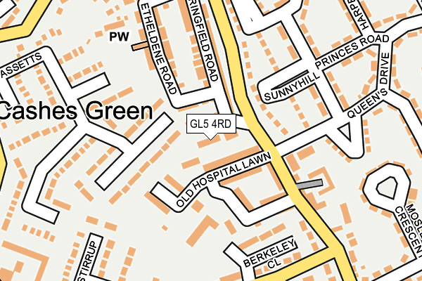
GL5 4RD lies on Old Hill in Stroud. GL5 4RD is located in the Cainscross electoral ward, within the local authority district of Stroud and the English Parliamentary constituency of Stroud. The Sub Integrated Care Board (ICB) Location is NHS Gloucestershire ICB - 11M and the police force is Gloucestershire. This postcode has been in use since January 1980.


GetTheData
Source: OS OpenMap – Local (Ordnance Survey)
Source: OS VectorMap District (Ordnance Survey)
Licence: Open Government Licence (requires attribution)
| Easting | 382934 |
| Northing | 205516 |
| Latitude | 51.748077 |
| Longitude | -2.248601 |
GetTheData
Source: Open Postcode Geo
Licence: Open Government Licence
| Street | Old Hill |
| Town/City | Stroud |
| Country | England |
| Postcode District | GL5 |
➜ See where GL5 is on a map ➜ Where is Stroud? | |
GetTheData
Source: Land Registry Price Paid Data
Licence: Open Government Licence
Elevation or altitude of GL5 4RD as distance above sea level:
| Metres | Feet | |
|---|---|---|
| Elevation | 70m | 230ft |
Elevation is measured from the approximate centre of the postcode, to the nearest point on an OS contour line from OS Terrain 50, which has contour spacing of ten vertical metres.
➜ How high above sea level am I? Find the elevation of your current position using your device's GPS.
GetTheData
Source: Open Postcode Elevation
Licence: Open Government Licence
| Ward | Cainscross |
| Constituency | Stroud |
GetTheData
Source: ONS Postcode Database
Licence: Open Government Licence
| Princes Road (Hillcrest Road) | Cashes Green | 185m |
| Queen's Drive | Cashes Green | 221m |
| The Beagles (Hunters Way) | Cashes Green | 234m |
| Primary School (Hillcrest Road) | Cashes Green | 273m |
| Mosley Road | Cashes Green | 283m |
| Stroud (Glos) Station | 2.1km |
| Stonehouse Station | 2.1km |
GetTheData
Source: NaPTAN
Licence: Open Government Licence
| Percentage of properties with Next Generation Access | 100.0% |
| Percentage of properties with Superfast Broadband | 100.0% |
| Percentage of properties with Ultrafast Broadband | 0.0% |
| Percentage of properties with Full Fibre Broadband | 0.0% |
Superfast Broadband is between 30Mbps and 300Mbps
Ultrafast Broadband is > 300Mbps
| Percentage of properties unable to receive 2Mbps | 0.0% |
| Percentage of properties unable to receive 5Mbps | 0.0% |
| Percentage of properties unable to receive 10Mbps | 0.0% |
| Percentage of properties unable to receive 30Mbps | 0.0% |
GetTheData
Source: Ofcom
Licence: Ofcom Terms of Use (requires attribution)
Estimated total energy consumption in GL5 4RD by fuel type, 2015.
| Consumption (kWh) | 71,349 |
|---|---|
| Meter count | 6 |
| Mean (kWh/meter) | 11,891 |
| Median (kWh/meter) | 7,196 |
GetTheData
Source: Postcode level gas estimates: 2015 (experimental)
Source: Postcode level electricity estimates: 2015 (experimental)
Licence: Open Government Licence
GetTheData
Source: ONS Postcode Database
Licence: Open Government Licence


➜ Get more ratings from the Food Standards Agency
GetTheData
Source: Food Standards Agency
Licence: FSA terms & conditions
| Last Collection | |||
|---|---|---|---|
| Location | Mon-Fri | Sat | Distance |
| Cashes Green P.o. | 17:15 | 11:45 | 45m |
| Hunters Way | 17:15 | 11:45 | 317m |
| The Bassetts Cashes Green | 17:15 | 11:45 | 317m |
GetTheData
Source: Dracos
Licence: Creative Commons Attribution-ShareAlike
The below table lists the International Territorial Level (ITL) codes (formerly Nomenclature of Territorial Units for Statistics (NUTS) codes) and Local Administrative Units (LAU) codes for GL5 4RD:
| ITL 1 Code | Name |
|---|---|
| TLK | South West (England) |
| ITL 2 Code | Name |
| TLK1 | Gloucestershire, Wiltshire and Bath/Bristol area |
| ITL 3 Code | Name |
| TLK13 | Gloucestershire CC |
| LAU 1 Code | Name |
| E07000082 | Stroud |
GetTheData
Source: ONS Postcode Directory
Licence: Open Government Licence
The below table lists the Census Output Area (OA), Lower Layer Super Output Area (LSOA), and Middle Layer Super Output Area (MSOA) for GL5 4RD:
| Code | Name | |
|---|---|---|
| OA | E00113648 | |
| LSOA | E01022357 | Stroud 004C |
| MSOA | E02004654 | Stroud 004 |
GetTheData
Source: ONS Postcode Directory
Licence: Open Government Licence
| GL5 4UZ | Springfield Road | 39m |
| GL5 4RF | Etheldene Road | 57m |
| GL5 4GA | Old Hospital Lawn | 59m |
| GL5 4RG | Springfield Road | 92m |
| GL5 4RE | Springfield Road | 116m |
| GL5 4RB | Cashes Green Road | 119m |
| GL5 4RQ | Springfield Road | 130m |
| GL5 4SL | The Bassetts | 146m |
| GL5 4NP | Sunnyhill | 150m |
| GL5 4SS | Spinning Wheel Court | 152m |
GetTheData
Source: Open Postcode Geo; Land Registry Price Paid Data
Licence: Open Government Licence