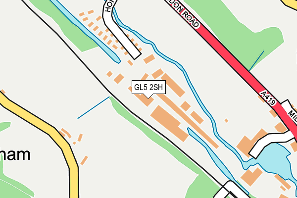
GL5 2SH is located in the Thrupp electoral ward, within the local authority district of Stroud and the English Parliamentary constituency of Stroud. The Sub Integrated Care Board (ICB) Location is NHS Gloucestershire ICB - 11M and the police force is Gloucestershire. This postcode has been in use since January 1980.


GetTheData
Source: OS OpenMap – Local (Ordnance Survey)
Source: OS VectorMap District (Ordnance Survey)
Licence: Open Government Licence (requires attribution)
| Easting | 386381 |
| Northing | 202614 |
| Latitude | 51.722080 |
| Longitude | -2.198557 |
GetTheData
Source: Open Postcode Geo
Licence: Open Government Licence
| Country | England |
| Postcode District | GL5 |
➜ See where GL5 is on a map ➜ Where is Brimscombe? | |
GetTheData
Source: Land Registry Price Paid Data
Licence: Open Government Licence
Elevation or altitude of GL5 2SH as distance above sea level:
| Metres | Feet | |
|---|---|---|
| Elevation | 60m | 197ft |
Elevation is measured from the approximate centre of the postcode, to the nearest point on an OS contour line from OS Terrain 50, which has contour spacing of ten vertical metres.
➜ How high above sea level am I? Find the elevation of your current position using your device's GPS.
GetTheData
Source: Open Postcode Elevation
Licence: Open Government Licence
| Ward | Thrupp |
| Constituency | Stroud |
GetTheData
Source: ONS Postcode Database
Licence: Open Government Licence
| Brewery Lane (London Road A419) | Thrupp | 261m |
| Brewery Lane (London Road A419) | Thrupp | 282m |
| Demand Responsive Area | Brimscombe | 360m |
| Bourne Lane (Thrupp Lane) | Brimscombe | 380m |
| Bourne Lane (Thrupp Lane) | Brimscombe | 386m |
| Stroud (Glos) Station | 2.9km |
GetTheData
Source: NaPTAN
Licence: Open Government Licence
| Median download speed | 79.9Mbps |
| Average download speed | 67.4Mbps |
| Maximum download speed | 80.00Mbps |
| Median upload speed | 19.3Mbps |
| Average upload speed | 15.5Mbps |
| Maximum upload speed | 20.00Mbps |
GetTheData
Source: Ofcom
Licence: Ofcom Terms of Use (requires attribution)
Estimated total energy consumption in GL5 2SH by fuel type, 2015.
| Consumption (kWh) | 83,840 |
|---|---|
| Meter count | 10 |
| Mean (kWh/meter) | 8,384 |
| Median (kWh/meter) | 5,051 |
GetTheData
Source: Postcode level gas estimates: 2015 (experimental)
Source: Postcode level electricity estimates: 2015 (experimental)
Licence: Open Government Licence
GetTheData
Source: ONS Postcode Database
Licence: Open Government Licence


➜ Get more ratings from the Food Standards Agency
GetTheData
Source: Food Standards Agency
Licence: FSA terms & conditions
| Last Collection | |||
|---|---|---|---|
| Location | Mon-Fri | Sat | Distance |
| Thrupp | 17:00 | 12:00 | 320m |
| Swells Hill Brimscombe | 15:45 | 10:30 | 443m |
| Upper Thrupp | 17:00 | 12:15 | 449m |
GetTheData
Source: Dracos
Licence: Creative Commons Attribution-ShareAlike
The below table lists the International Territorial Level (ITL) codes (formerly Nomenclature of Territorial Units for Statistics (NUTS) codes) and Local Administrative Units (LAU) codes for GL5 2SH:
| ITL 1 Code | Name |
|---|---|
| TLK | South West (England) |
| ITL 2 Code | Name |
| TLK1 | Gloucestershire, Wiltshire and Bath/Bristol area |
| ITL 3 Code | Name |
| TLK13 | Gloucestershire CC |
| LAU 1 Code | Name |
| E07000082 | Stroud |
GetTheData
Source: ONS Postcode Directory
Licence: Open Government Licence
The below table lists the Census Output Area (OA), Lower Layer Super Output Area (LSOA), and Middle Layer Super Output Area (MSOA) for GL5 2SH:
| Code | Name | |
|---|---|---|
| OA | E00113909 | |
| LSOA | E01022409 | Stroud 007E |
| MSOA | E02004657 | Stroud 007 |
GetTheData
Source: ONS Postcode Directory
Licence: Open Government Licence
| GL5 2SG | London Road | 46m |
| GL5 2SE | Hope Mills Business Centre | 67m |
| GL5 2RT | Mill Close | 318m |
| GL5 2EB | Dallaway Estate | 333m |
| GL5 2EF | Thrupp Lane | 347m |
| GL5 2BN | London Road | 354m |
| GL5 2DY | Brewery Lane | 363m |
| GL5 2ED | Thrupp Lane | 368m |
| GL5 2RB | Orchard Lane | 376m |
| GL5 2DX | Spring Lane | 386m |
GetTheData
Source: Open Postcode Geo; Land Registry Price Paid Data
Licence: Open Government Licence