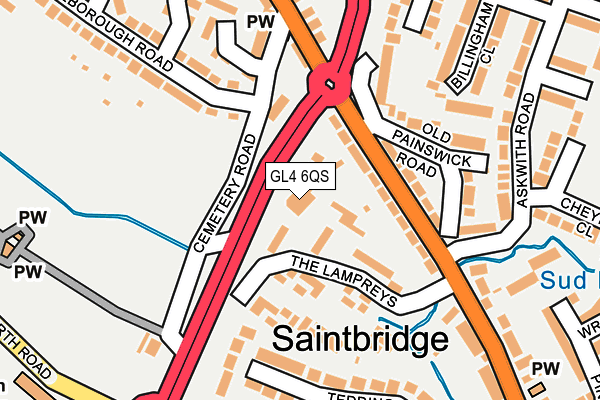
GL4 6QS lies on Eastern Avenue in Gloucester. GL4 6QS is located in the Matson, Robinswood and White City electoral ward, within the local authority district of Gloucester and the English Parliamentary constituency of Gloucester. The Sub Integrated Care Board (ICB) Location is NHS Gloucestershire ICB - 11M and the police force is Gloucestershire. This postcode has been in use since December 1995.


GetTheData
Source: OS OpenMap – Local (Ordnance Survey)
Source: OS VectorMap District (Ordnance Survey)
Licence: Open Government Licence (requires attribution)
| Easting | 384562 |
| Northing | 216829 |
| Latitude | 51.849846 |
| Longitude | -2.225524 |
GetTheData
Source: Open Postcode Geo
Licence: Open Government Licence
| Street | Eastern Avenue |
| Town/City | Gloucester |
| Country | England |
| Postcode District | GL4 |
➜ See where GL4 is on a map ➜ Where is Gloucester? | |
GetTheData
Source: Land Registry Price Paid Data
Licence: Open Government Licence
Elevation or altitude of GL4 6QS as distance above sea level:
| Metres | Feet | |
|---|---|---|
| Elevation | 30m | 98ft |
Elevation is measured from the approximate centre of the postcode, to the nearest point on an OS contour line from OS Terrain 50, which has contour spacing of ten vertical metres.
➜ How high above sea level am I? Find the elevation of your current position using your device's GPS.
GetTheData
Source: Open Postcode Elevation
Licence: Open Government Licence
| Ward | Matson, Robinswood And White City |
| Constituency | Gloucester |
GetTheData
Source: ONS Postcode Database
Licence: Open Government Licence
| The Lampreys (Painswick Road) | Saintbridge | 82m |
| Cemetery Road (Painswick Road) | Gloucester | 150m |
| The Lampreys (Painswick Road) | Saintbridge | 188m |
| Chequers Chippy (Painswick Road) | Gloucester | 323m |
| Finlay Primary School (Tredworth Road) | White City | 335m |
| Gloucester Station | 2km |
GetTheData
Source: NaPTAN
Licence: Open Government Licence
GetTheData
Source: ONS Postcode Database
Licence: Open Government Licence


➜ Get more ratings from the Food Standards Agency
GetTheData
Source: Food Standards Agency
Licence: FSA terms & conditions
| Last Collection | |||
|---|---|---|---|
| Location | Mon-Fri | Sat | Distance |
| The Lampreys | 17:45 | 12:30 | 166m |
| Kingsley Road | 17:30 | 12:15 | 510m |
| Willow Avenue | 17:30 | 12:15 | 523m |
GetTheData
Source: Dracos
Licence: Creative Commons Attribution-ShareAlike
The below table lists the International Territorial Level (ITL) codes (formerly Nomenclature of Territorial Units for Statistics (NUTS) codes) and Local Administrative Units (LAU) codes for GL4 6QS:
| ITL 1 Code | Name |
|---|---|
| TLK | South West (England) |
| ITL 2 Code | Name |
| TLK1 | Gloucestershire, Wiltshire and Bath/Bristol area |
| ITL 3 Code | Name |
| TLK13 | Gloucestershire CC |
| LAU 1 Code | Name |
| E07000081 | Gloucester |
GetTheData
Source: ONS Postcode Directory
Licence: Open Government Licence
The below table lists the Census Output Area (OA), Lower Layer Super Output Area (LSOA), and Middle Layer Super Output Area (MSOA) for GL4 6QS:
| Code | Name | |
|---|---|---|
| OA | E00113468 | |
| LSOA | E01022321 | Gloucester 011C |
| MSOA | E02004646 | Gloucester 011 |
GetTheData
Source: ONS Postcode Directory
Licence: Open Government Licence
| GL4 4PZ | Painswick Road | 79m |
| GL4 4PY | Painswick Road | 94m |
| GL4 4AU | Old Painswick Close | 100m |
| GL4 6PB | Cemetery Road | 117m |
| GL4 4LH | Eastern Avenue | 130m |
| GL4 4PX | Old Painswick Road | 130m |
| GL4 6QU | The Lampreys | 165m |
| GL4 6BT | Lancaster Grove | 173m |
| GL4 4PW | Askwith Road | 186m |
| GL4 6GD | Marlborough Road | 187m |
GetTheData
Source: Open Postcode Geo; Land Registry Price Paid Data
Licence: Open Government Licence