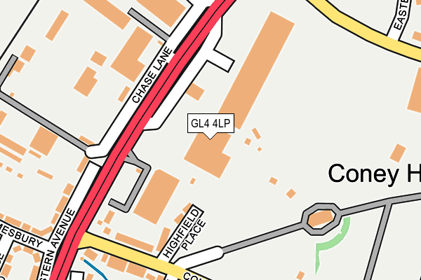
GL4 4LP lies on Eastern Avenue in Gloucester. GL4 4LP is located in the Coney Hill electoral ward, within the local authority district of Gloucester and the English Parliamentary constituency of Gloucester. The Sub Integrated Care Board (ICB) Location is NHS Gloucestershire ICB - 11M and the police force is Gloucestershire. This postcode has been in use since December 1995.


GetTheData
Source: OS OpenMap – Local (Ordnance Survey)
Source: OS VectorMap District (Ordnance Survey)
Licence: Open Government Licence (requires attribution)
| Easting | 384858 |
| Northing | 217459 |
| Latitude | 51.855519 |
| Longitude | -2.221254 |
GetTheData
Source: Open Postcode Geo
Licence: Open Government Licence
| Street | Eastern Avenue |
| Town/City | Gloucester |
| Country | England |
| Postcode District | GL4 |
➜ See where GL4 is on a map ➜ Where is Gloucester? | |
GetTheData
Source: Land Registry Price Paid Data
Licence: Open Government Licence
Elevation or altitude of GL4 4LP as distance above sea level:
| Metres | Feet | |
|---|---|---|
| Elevation | 30m | 98ft |
Elevation is measured from the approximate centre of the postcode, to the nearest point on an OS contour line from OS Terrain 50, which has contour spacing of ten vertical metres.
➜ How high above sea level am I? Find the elevation of your current position using your device's GPS.
GetTheData
Source: Open Postcode Elevation
Licence: Open Government Licence
| Ward | Coney Hill |
| Constituency | Gloucester |
GetTheData
Source: ONS Postcode Database
Licence: Open Government Licence
| Bennetts Depot (Eastern Avenue) | Coney Hill | 104m |
| Crematorium (Coney Hill Road) | Coney Hill | 206m |
| Twin Gables (Coney Hill Road) | Coney Hill | 208m |
| Eastbrook Trading Estate (Metz Way) | Gloucester | 234m |
| Willow Avenue (Coney Hill Road) | Coney Hill | 243m |
| Gloucester Station | 1.6km |
GetTheData
Source: NaPTAN
Licence: Open Government Licence
GetTheData
Source: ONS Postcode Database
Licence: Open Government Licence


➜ Get more ratings from the Food Standards Agency
GetTheData
Source: Food Standards Agency
Licence: FSA terms & conditions
| Last Collection | |||
|---|---|---|---|
| Location | Mon-Fri | Sat | Distance |
| Eastern Avenue | 17:00 | 12:45 | 185m |
| Willow Avenue | 17:30 | 12:15 | 263m |
| Chester Road | 17:30 | 12:00 | 727m |
GetTheData
Source: Dracos
Licence: Creative Commons Attribution-ShareAlike
The below table lists the International Territorial Level (ITL) codes (formerly Nomenclature of Territorial Units for Statistics (NUTS) codes) and Local Administrative Units (LAU) codes for GL4 4LP:
| ITL 1 Code | Name |
|---|---|
| TLK | South West (England) |
| ITL 2 Code | Name |
| TLK1 | Gloucestershire, Wiltshire and Bath/Bristol area |
| ITL 3 Code | Name |
| TLK13 | Gloucestershire CC |
| LAU 1 Code | Name |
| E07000081 | Gloucester |
GetTheData
Source: ONS Postcode Directory
Licence: Open Government Licence
The below table lists the Census Output Area (OA), Lower Layer Super Output Area (LSOA), and Middle Layer Super Output Area (MSOA) for GL4 4LP:
| Code | Name | |
|---|---|---|
| OA | E00113291 | |
| LSOA | E01022284 | Gloucester 007D |
| MSOA | E02004642 | Gloucester 007 |
GetTheData
Source: ONS Postcode Directory
Licence: Open Government Licence
| GL4 6PQ | Eastern Avenue | 140m |
| GL4 4PB | Highfield Place | 168m |
| GL4 4LS | Coney Hill Road | 233m |
| GL4 6PE | Eastern Avenue | 238m |
| GL4 4LQ | Nut Croft | 266m |
| GL4 3SJ | Eastville Close | 266m |
| GL4 4AX | Filton Way | 325m |
| GL4 4LT | Coney Hill Road | 326m |
| GL4 6BH | Malmesbury Road | 327m |
| GL4 4LW | Eastern Avenue | 331m |
GetTheData
Source: Open Postcode Geo; Land Registry Price Paid Data
Licence: Open Government Licence