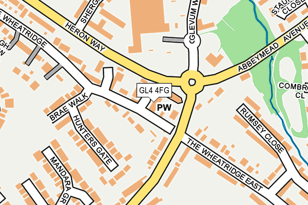
GL4 4FG is located in the Abbeydale electoral ward, within the local authority district of Gloucester and the English Parliamentary constituency of Gloucester. The Sub Integrated Care Board (ICB) Location is NHS Gloucestershire ICB - 11M and the police force is Gloucestershire. This postcode has been in use since December 1995.


GetTheData
Source: OS OpenMap – Local (Ordnance Survey)
Source: OS VectorMap District (Ordnance Survey)
Licence: Open Government Licence (requires attribution)
| Easting | 385934 |
| Northing | 215743 |
| Latitude | 51.840112 |
| Longitude | -2.205565 |
GetTheData
Source: Open Postcode Geo
Licence: Open Government Licence
| Country | England |
| Postcode District | GL4 |
➜ See where GL4 is on a map ➜ Where is Gloucester? | |
GetTheData
Source: Land Registry Price Paid Data
Licence: Open Government Licence
Elevation or altitude of GL4 4FG as distance above sea level:
| Metres | Feet | |
|---|---|---|
| Elevation | 50m | 164ft |
Elevation is measured from the approximate centre of the postcode, to the nearest point on an OS contour line from OS Terrain 50, which has contour spacing of ten vertical metres.
➜ How high above sea level am I? Find the elevation of your current position using your device's GPS.
GetTheData
Source: Open Postcode Elevation
Licence: Open Government Licence
| Ward | Abbeydale |
| Constituency | Gloucester |
GetTheData
Source: ONS Postcode Database
Licence: Open Government Licence
| Christchurch (Wheatway) | Abbeydale | 63m |
| Christchurch (Wheatway) | Abbeydale | 66m |
| Morrisons (Heron Way) | Abbeydale | 80m |
| Morrisons (Heron Way) | Abbeydale | 85m |
| Glevum Centre | Abbeydale | 131m |
| Gloucester Station | 3.6km |
GetTheData
Source: NaPTAN
Licence: Open Government Licence
| Percentage of properties with Next Generation Access | 100.0% |
| Percentage of properties with Superfast Broadband | 100.0% |
| Percentage of properties with Ultrafast Broadband | 0.0% |
| Percentage of properties with Full Fibre Broadband | 0.0% |
Superfast Broadband is between 30Mbps and 300Mbps
Ultrafast Broadband is > 300Mbps
| Percentage of properties unable to receive 2Mbps | 0.0% |
| Percentage of properties unable to receive 5Mbps | 0.0% |
| Percentage of properties unable to receive 10Mbps | 0.0% |
| Percentage of properties unable to receive 30Mbps | 0.0% |
GetTheData
Source: Ofcom
Licence: Ofcom Terms of Use (requires attribution)
Estimated total energy consumption in GL4 4FG by fuel type, 2015.
| Consumption (kWh) | 52,017 |
|---|---|
| Meter count | 8 |
| Mean (kWh/meter) | 6,502 |
| Median (kWh/meter) | 6,480 |
| Consumption (kWh) | 19,663 |
|---|---|
| Meter count | 8 |
| Mean (kWh/meter) | 2,458 |
| Median (kWh/meter) | 2,649 |
GetTheData
Source: Postcode level gas estimates: 2015 (experimental)
Source: Postcode level electricity estimates: 2015 (experimental)
Licence: Open Government Licence
GetTheData
Source: ONS Postcode Database
Licence: Open Government Licence


➜ Get more ratings from the Food Standards Agency
GetTheData
Source: Food Standards Agency
Licence: FSA terms & conditions
| Last Collection | |||
|---|---|---|---|
| Location | Mon-Fri | Sat | Distance |
| Matson Avenue | 17:15 | 12:30 | 699m |
| Honeysuckle Drive | 17:30 | 12:30 | 732m |
| Matson (Pitch) | 17:30 | 12:15 | 747m |
GetTheData
Source: Dracos
Licence: Creative Commons Attribution-ShareAlike
The below table lists the International Territorial Level (ITL) codes (formerly Nomenclature of Territorial Units for Statistics (NUTS) codes) and Local Administrative Units (LAU) codes for GL4 4FG:
| ITL 1 Code | Name |
|---|---|
| TLK | South West (England) |
| ITL 2 Code | Name |
| TLK1 | Gloucestershire, Wiltshire and Bath/Bristol area |
| ITL 3 Code | Name |
| TLK13 | Gloucestershire CC |
| LAU 1 Code | Name |
| E07000081 | Gloucester |
GetTheData
Source: ONS Postcode Directory
Licence: Open Government Licence
The below table lists the Census Output Area (OA), Lower Layer Super Output Area (LSOA), and Middle Layer Super Output Area (MSOA) for GL4 4FG:
| Code | Name | |
|---|---|---|
| OA | E00113252 | |
| LSOA | E01022277 | Gloucester 010B |
| MSOA | E02004645 | Gloucester 010 |
GetTheData
Source: ONS Postcode Directory
Licence: Open Government Licence
| GL4 4AS | The Wayridge | 40m |
| GL4 5DN | The Wheatridge | 64m |
| GL4 4AT | Claridge Close | 90m |
| GL4 4BH | Heron Way | 105m |
| GL4 5FE | Hunters Gate | 156m |
| GL4 5DW | The Wheatridge East | 161m |
| GL4 5FA | Brae Walk | 179m |
| GL4 4BJ | Wheatway | 187m |
| GL4 5UA | Abbeymead Avenue | 187m |
| GL4 4BG | The Wheatridge | 218m |
GetTheData
Source: Open Postcode Geo; Land Registry Price Paid Data
Licence: Open Government Licence