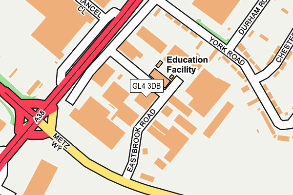
GL4 3DB lies on Eastbrook Road in Gloucester. GL4 3DB is located in the Barnwood electoral ward, within the local authority district of Gloucester and the English Parliamentary constituency of Gloucester. The Sub Integrated Care Board (ICB) Location is NHS Gloucestershire ICB - 11M and the police force is Gloucestershire. This postcode has been in use since December 1995.


GetTheData
Source: OS OpenMap – Local (Ordnance Survey)
Source: OS VectorMap District (Ordnance Survey)
Licence: Open Government Licence (requires attribution)
| Easting | 385154 |
| Northing | 217757 |
| Latitude | 51.858199 |
| Longitude | -2.216973 |
GetTheData
Source: Open Postcode Geo
Licence: Open Government Licence
| Street | Eastbrook Road |
| Town/City | Gloucester |
| Country | England |
| Postcode District | GL4 |
➜ See where GL4 is on a map ➜ Where is Gloucester? | |
GetTheData
Source: Land Registry Price Paid Data
Licence: Open Government Licence
Elevation or altitude of GL4 3DB as distance above sea level:
| Metres | Feet | |
|---|---|---|
| Elevation | 30m | 98ft |
Elevation is measured from the approximate centre of the postcode, to the nearest point on an OS contour line from OS Terrain 50, which has contour spacing of ten vertical metres.
➜ How high above sea level am I? Find the elevation of your current position using your device's GPS.
GetTheData
Source: Open Postcode Elevation
Licence: Open Government Licence
| Ward | Barnwood |
| Constituency | Gloucester |
GetTheData
Source: ONS Postcode Database
Licence: Open Government Licence
E D C M PRECISION WIRE EROSION LTD, EASTBROOK ROAD, GLOUCESTER, GL4 3DB 2004 24 AUG £200,000 |
7, EASTBROOK ROAD, GLOUCESTER, GL4 3DB 2003 24 APR £370,000 |
GetTheData
Source: HM Land Registry Price Paid Data
Licence: Contains HM Land Registry data © Crown copyright and database right 2025. This data is licensed under the Open Government Licence v3.0.
| Eastbrook Trading Estate (Metz Way) | Gloucester | 172m |
| Gloucester Retail Park (York Road) | Gloucester | 188m |
| Eastbrook Trading Estate (Metz Way) | Gloucester | 189m |
| Gloucester Retail Park (York Road) | Gloucester | 189m |
| Chester Road | Gloucester | 324m |
| Gloucester Station | 1.7km |
GetTheData
Source: NaPTAN
Licence: Open Government Licence
Estimated total energy consumption in GL4 3DB by fuel type, 2015.
| Consumption (kWh) | 123,815 |
|---|---|
| Meter count | 7 |
| Mean (kWh/meter) | 17,688 |
| Median (kWh/meter) | 4,745 |
GetTheData
Source: Postcode level gas estimates: 2015 (experimental)
Source: Postcode level electricity estimates: 2015 (experimental)
Licence: Open Government Licence
GetTheData
Source: ONS Postcode Database
Licence: Open Government Licence


➜ Get more ratings from the Food Standards Agency
GetTheData
Source: Food Standards Agency
Licence: FSA terms & conditions
| Last Collection | |||
|---|---|---|---|
| Location | Mon-Fri | Sat | Distance |
| Chester Road | 17:30 | 12:00 | 324m |
| Eastern Avenue | 17:00 | 12:45 | 352m |
| Willow Avenue | 17:30 | 12:15 | 598m |
GetTheData
Source: Dracos
Licence: Creative Commons Attribution-ShareAlike
The below table lists the International Territorial Level (ITL) codes (formerly Nomenclature of Territorial Units for Statistics (NUTS) codes) and Local Administrative Units (LAU) codes for GL4 3DB:
| ITL 1 Code | Name |
|---|---|
| TLK | South West (England) |
| ITL 2 Code | Name |
| TLK1 | Gloucestershire, Wiltshire and Bath/Bristol area |
| ITL 3 Code | Name |
| TLK13 | Gloucestershire CC |
| LAU 1 Code | Name |
| E07000081 | Gloucester |
GetTheData
Source: ONS Postcode Directory
Licence: Open Government Licence
The below table lists the Census Output Area (OA), Lower Layer Super Output Area (LSOA), and Middle Layer Super Output Area (MSOA) for GL4 3DB:
| Code | Name | |
|---|---|---|
| OA | E00113276 | |
| LSOA | E01022287 | Gloucester 007G |
| MSOA | E02004642 | Gloucester 007 |
GetTheData
Source: ONS Postcode Directory
Licence: Open Government Licence
| GL4 3AZ | York Road | 163m |
| GL4 3AT | York Road | 223m |
| GL4 3AR | Durham Road | 250m |
| GL4 3AU | York Road | 254m |
| GL4 3BA | York Road | 269m |
| GL4 3AX | Chester Road | 280m |
| GL4 3AS | Durham Road | 357m |
| GL4 3AY | Chester Road | 359m |
| GL4 3AL | Lichfield Road | 368m |
| GL4 3SJ | Eastville Close | 375m |
GetTheData
Source: Open Postcode Geo; Land Registry Price Paid Data
Licence: Open Government Licence