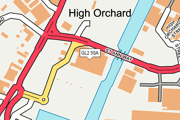
GL2 5SA is located in the Westgate electoral ward, within the local authority district of Gloucester and the English Parliamentary constituency of Gloucester. The Sub Integrated Care Board (ICB) Location is NHS Gloucestershire ICB - 11M and the police force is Gloucestershire. This postcode has been in use since May 2009.


GetTheData
Source: OS OpenMap – Local (Ordnance Survey)
Source: OS VectorMap District (Ordnance Survey)
Licence: Open Government Licence (requires attribution)
| Easting | 382370 |
| Northing | 217809 |
| Latitude | 51.858585 |
| Longitude | -2.257400 |
GetTheData
Source: Open Postcode Geo
Licence: Open Government Licence
| Country | England |
| Postcode District | GL2 |
➜ See where GL2 is on a map ➜ Where is Gloucester? | |
GetTheData
Source: Land Registry Price Paid Data
Licence: Open Government Licence
Elevation or altitude of GL2 5SA as distance above sea level:
| Metres | Feet | |
|---|---|---|
| Elevation | 10m | 33ft |
Elevation is measured from the approximate centre of the postcode, to the nearest point on an OS contour line from OS Terrain 50, which has contour spacing of ten vertical metres.
➜ How high above sea level am I? Find the elevation of your current position using your device's GPS.
GetTheData
Source: Open Postcode Elevation
Licence: Open Government Licence
| Ward | Westgate |
| Constituency | Gloucester |
GetTheData
Source: ONS Postcode Database
Licence: Open Government Licence
| Sainsbury's Supermarket (Sainsbury Crescent) | Hempsted | 128m |
| Sainsbury's Supermarket | Hempsted | 147m |
| Sainsbury's (St Anne Way) | Hempsted | 148m |
| Sainsbury's (St Anne Way) | Hempsted | 157m |
| Llanthony Priory (Llanthony Road) | Gloucester | 227m |
| Gloucester Station | 1.5km |
GetTheData
Source: NaPTAN
Licence: Open Government Licence
GetTheData
Source: ONS Postcode Database
Licence: Open Government Licence


➜ Get more ratings from the Food Standards Agency
GetTheData
Source: Food Standards Agency
Licence: FSA terms & conditions
| Last Collection | |||
|---|---|---|---|
| Location | Mon-Fri | Sat | Distance |
| Olympus Park Quedgeley | 18:50 | 10:30 | 464m |
| Waterways Museum | 18:30 | 12:30 | 490m |
| Bristol Road | 17:40 | 12:30 | 530m |
GetTheData
Source: Dracos
Licence: Creative Commons Attribution-ShareAlike
The below table lists the International Territorial Level (ITL) codes (formerly Nomenclature of Territorial Units for Statistics (NUTS) codes) and Local Administrative Units (LAU) codes for GL2 5SA:
| ITL 1 Code | Name |
|---|---|
| TLK | South West (England) |
| ITL 2 Code | Name |
| TLK1 | Gloucestershire, Wiltshire and Bath/Bristol area |
| ITL 3 Code | Name |
| TLK13 | Gloucestershire CC |
| LAU 1 Code | Name |
| E07000081 | Gloucester |
GetTheData
Source: ONS Postcode Directory
Licence: Open Government Licence
The below table lists the Census Output Area (OA), Lower Layer Super Output Area (LSOA), and Middle Layer Super Output Area (MSOA) for GL2 5SA:
| Code | Name | |
|---|---|---|
| OA | E00168948 | |
| LSOA | E01022348 | Gloucester 004C |
| MSOA | E02004639 | Gloucester 004 |
GetTheData
Source: ONS Postcode Directory
Licence: Open Government Licence
| GL2 5JA | Hempsted Lane | 233m |
| GL2 5QT | Llanthony Road | 278m |
| GL2 5FD | Spinnaker Road | 281m |
| GL2 5HD | Sudmeadow Road | 314m |
| GL2 5HN | Hemmingsdale Road | 342m |
| GL2 5HL | 354m | |
| GL2 5FT | Maritime Court | 364m |
| GL2 5FY | Atlas Court | 423m |
| GL2 5FS | Jetty Road | 426m |
| GL2 5RB | Church Street | 453m |
GetTheData
Source: Open Postcode Geo; Land Registry Price Paid Data
Licence: Open Government Licence