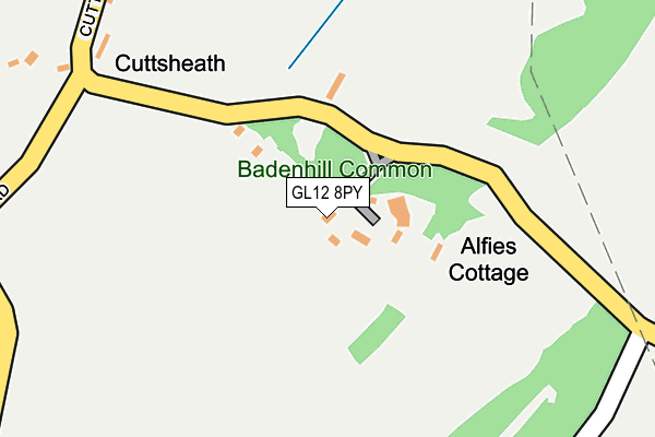
GL12 8PY lies on Baden Hill in Tytherington, Wotton-under-edge. GL12 8PY is located in the Frampton Cotterell electoral ward, within the unitary authority of South Gloucestershire and the English Parliamentary constituency of Thornbury and Yate. The Sub Integrated Care Board (ICB) Location is NHS Bristol, North Somerset and South Gloucestershire ICB - 15C and the police force is Avon and Somerset. This postcode has been in use since January 1980.


GetTheData
Source: OS OpenMap – Local (Ordnance Survey)
Source: OS VectorMap District (Ordnance Survey)
Licence: Open Government Licence (requires attribution)
| Easting | 367528 |
| Northing | 189214 |
| Latitude | 51.600824 |
| Longitude | -2.470229 |
GetTheData
Source: Open Postcode Geo
Licence: Open Government Licence
| Street | Baden Hill |
| Locality | Tytherington |
| Town/City | Wotton-under-edge |
| Country | England |
| Postcode District | GL12 |
➜ See where GL12 is on a map | |
GetTheData
Source: Land Registry Price Paid Data
Licence: Open Government Licence
Elevation or altitude of GL12 8PY as distance above sea level:
| Metres | Feet | |
|---|---|---|
| Elevation | 90m | 295ft |
Elevation is measured from the approximate centre of the postcode, to the nearest point on an OS contour line from OS Terrain 50, which has contour spacing of ten vertical metres.
➜ How high above sea level am I? Find the elevation of your current position using your device's GPS.
GetTheData
Source: Open Postcode Elevation
Licence: Open Government Licence
| Ward | Frampton Cotterell |
| Constituency | Thornbury And Yate |
GetTheData
Source: ONS Postcode Database
Licence: Open Government Licence
| Stowell Hill Road (Tytherington Road) | Tytherington | 1,058m |
| Stowell Hill Road (Tytherington Road) | Tytherington | 1,073m |
| Duck Street | Tytherington | 1,099m |
| Duck Street | Tytherington | 1,109m |
| The Swan (West Street) | Tytherington | 1,154m |
GetTheData
Source: NaPTAN
Licence: Open Government Licence
| Percentage of properties with Next Generation Access | 100.0% |
| Percentage of properties with Superfast Broadband | 76.9% |
| Percentage of properties with Ultrafast Broadband | 76.9% |
| Percentage of properties with Full Fibre Broadband | 76.9% |
Superfast Broadband is between 30Mbps and 300Mbps
Ultrafast Broadband is > 300Mbps
| Median download speed | 16.2Mbps |
| Average download speed | 15.8Mbps |
| Maximum download speed | 37.04Mbps |
| Median upload speed | 1.3Mbps |
| Average upload speed | 2.0Mbps |
| Maximum upload speed | 5.68Mbps |
| Percentage of properties unable to receive 2Mbps | 0.0% |
| Percentage of properties unable to receive 5Mbps | 0.0% |
| Percentage of properties unable to receive 10Mbps | 0.0% |
| Percentage of properties unable to receive 30Mbps | 23.1% |
GetTheData
Source: Ofcom
Licence: Ofcom Terms of Use (requires attribution)
Estimated total energy consumption in GL12 8PY by fuel type, 2015.
| Consumption (kWh) | 72,281 |
|---|---|
| Meter count | 12 |
| Mean (kWh/meter) | 6,023 |
| Median (kWh/meter) | 4,929 |
GetTheData
Source: Postcode level gas estimates: 2015 (experimental)
Source: Postcode level electricity estimates: 2015 (experimental)
Licence: Open Government Licence
GetTheData
Source: ONS Postcode Database
Licence: Open Government Licence


➜ Get more ratings from the Food Standards Agency
GetTheData
Source: Food Standards Agency
Licence: FSA terms & conditions
| Last Collection | |||
|---|---|---|---|
| Location | Mon-Fri | Sat | Distance |
| Baden Hill Tytherington | 16:00 | 07:30 | 275m |
| West Street Tytherington | 16:30 | 09:10 | 1,168m |
| Buckover | 16:00 | 09:15 | 1,458m |
GetTheData
Source: Dracos
Licence: Creative Commons Attribution-ShareAlike
The below table lists the International Territorial Level (ITL) codes (formerly Nomenclature of Territorial Units for Statistics (NUTS) codes) and Local Administrative Units (LAU) codes for GL12 8PY:
| ITL 1 Code | Name |
|---|---|
| TLK | South West (England) |
| ITL 2 Code | Name |
| TLK1 | Gloucestershire, Wiltshire and Bath/Bristol area |
| ITL 3 Code | Name |
| TLK12 | Bath and North East Somerset, North Somerset and South Gloucestershire |
| LAU 1 Code | Name |
| E06000025 | South Gloucestershire |
GetTheData
Source: ONS Postcode Directory
Licence: Open Government Licence
The below table lists the Census Output Area (OA), Lower Layer Super Output Area (LSOA), and Middle Layer Super Output Area (MSOA) for GL12 8PY:
| Code | Name | |
|---|---|---|
| OA | E00075751 | |
| LSOA | E01014993 | South Gloucestershire 002D |
| MSOA | E02003091 | South Gloucestershire 002 |
GetTheData
Source: ONS Postcode Directory
Licence: Open Government Licence
| GL12 8PS | 626m | |
| GL12 8UR | Tytherington Hill | 736m |
| GL12 8UG | Baden Hill Road | 838m |
| GL12 8PX | 839m | |
| GL12 8US | The Jays | 932m |
| GL12 8UN | Stowell Lane | 978m |
| GL12 8QD | Stidcott | 979m |
| GL12 8UU | Woodlands Road | 987m |
| GL12 8UP | New Road | 992m |
| GL12 8UJ | Woodlands | 997m |
GetTheData
Source: Open Postcode Geo; Land Registry Price Paid Data
Licence: Open Government Licence