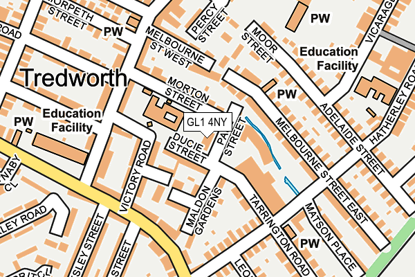
GL1 4NY is located in the Barton and Tredworth electoral ward, within the local authority district of Gloucester and the English Parliamentary constituency of Gloucester. The Sub Integrated Care Board (ICB) Location is NHS Gloucestershire ICB - 11M and the police force is Gloucestershire. This postcode has been in use since January 1980.


GetTheData
Source: OS OpenMap – Local (Ordnance Survey)
Source: OS VectorMap District (Ordnance Survey)
Licence: Open Government Licence (requires attribution)
| Easting | 383921 |
| Northing | 217179 |
| Latitude | 51.852975 |
| Longitude | -2.234846 |
GetTheData
Source: Open Postcode Geo
Licence: Open Government Licence
| Country | England |
| Postcode District | GL1 |
➜ See where GL1 is on a map ➜ Where is Gloucester? | |
GetTheData
Source: Land Registry Price Paid Data
Licence: Open Government Licence
Elevation or altitude of GL1 4NY as distance above sea level:
| Metres | Feet | |
|---|---|---|
| Elevation | 20m | 66ft |
Elevation is measured from the approximate centre of the postcode, to the nearest point on an OS contour line from OS Terrain 50, which has contour spacing of ten vertical metres.
➜ How high above sea level am I? Find the elevation of your current position using your device's GPS.
GetTheData
Source: Open Postcode Elevation
Licence: Open Government Licence
| Ward | Barton And Tredworth |
| Constituency | Gloucester |
GetTheData
Source: ONS Postcode Database
Licence: Open Government Licence
THE NORVILLE GROUP LTD, PAUL STREET, GLOUCESTER, GL1 4NY 2017 3 FEB £903,300 |
GetTheData
Source: HM Land Registry Price Paid Data
Licence: Contains HM Land Registry data © Crown copyright and database right 2025. This data is licensed under the Open Government Licence v3.0.
| Victory Hotel (High Street) | Tredworth | 185m |
| Hatherley Road (Tredworth Road) | Tredworth | 191m |
| Melbourne St West (High Street) | Tredworth | 194m |
| Melbourne St West (High Street) | Tredworth | 210m |
| Junior School (High Street) | Tredworth | 213m |
| Gloucester Station | 1.4km |
GetTheData
Source: NaPTAN
Licence: Open Government Licence
| Percentage of properties with Next Generation Access | 100.0% |
| Percentage of properties with Superfast Broadband | 100.0% |
| Percentage of properties with Ultrafast Broadband | 100.0% |
| Percentage of properties with Full Fibre Broadband | 100.0% |
Superfast Broadband is between 30Mbps and 300Mbps
Ultrafast Broadband is > 300Mbps
| Percentage of properties unable to receive 2Mbps | 0.0% |
| Percentage of properties unable to receive 5Mbps | 0.0% |
| Percentage of properties unable to receive 10Mbps | 0.0% |
| Percentage of properties unable to receive 30Mbps | 0.0% |
GetTheData
Source: Ofcom
Licence: Ofcom Terms of Use (requires attribution)
GetTheData
Source: ONS Postcode Database
Licence: Open Government Licence


➜ Get more ratings from the Food Standards Agency
GetTheData
Source: Food Standards Agency
Licence: FSA terms & conditions
| Last Collection | |||
|---|---|---|---|
| Location | Mon-Fri | Sat | Distance |
| Upton Street | 17:30 | 12:45 | 212m |
| Hatherley Road | 17:30 | 12:45 | 213m |
| Stroud Road P.o. | 17:30 | 12:15 | 513m |
GetTheData
Source: Dracos
Licence: Creative Commons Attribution-ShareAlike
The below table lists the International Territorial Level (ITL) codes (formerly Nomenclature of Territorial Units for Statistics (NUTS) codes) and Local Administrative Units (LAU) codes for GL1 4NY:
| ITL 1 Code | Name |
|---|---|
| TLK | South West (England) |
| ITL 2 Code | Name |
| TLK1 | Gloucestershire, Wiltshire and Bath/Bristol area |
| ITL 3 Code | Name |
| TLK13 | Gloucestershire CC |
| LAU 1 Code | Name |
| E07000081 | Gloucester |
GetTheData
Source: ONS Postcode Directory
Licence: Open Government Licence
The below table lists the Census Output Area (OA), Lower Layer Super Output Area (LSOA), and Middle Layer Super Output Area (MSOA) for GL1 4NY:
| Code | Name | |
|---|---|---|
| OA | E00113313 | |
| LSOA | E01022294 | Gloucester 008B |
| MSOA | E02004643 | Gloucester 008 |
GetTheData
Source: ONS Postcode Directory
Licence: Open Government Licence
| GL1 4NZ | Ducie Street | 68m |
| GL1 4NR | Melbourne Street East | 76m |
| GL1 4PD | Ducie Street | 77m |
| GL1 4PE | Tarrington Road | 86m |
| GL1 4NU | Melbourne Street East | 91m |
| GL1 4NS | Melbourne Street East | 95m |
| GL1 4PB | Massey Parade | 109m |
| GL1 4NX | Moreton Street | 111m |
| GL1 4PS | Maldon Gardens | 114m |
| GL1 4NJ | Moor Street | 124m |
GetTheData
Source: Open Postcode Geo; Land Registry Price Paid Data
Licence: Open Government Licence