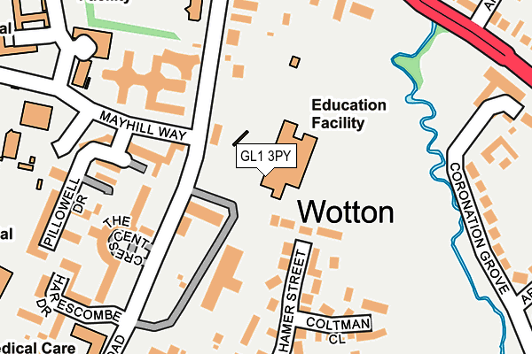
GL1 3PY is located in the Elmbridge electoral ward, within the local authority district of Gloucester and the English Parliamentary constituency of Gloucester. The Sub Integrated Care Board (ICB) Location is NHS Gloucestershire ICB - 11M and the police force is Gloucestershire. This postcode has been in use since January 1980.


GetTheData
Source: OS OpenMap – Local (Ordnance Survey)
Source: OS VectorMap District (Ordnance Survey)
Licence: Open Government Licence (requires attribution)
| Easting | 384549 |
| Northing | 218623 |
| Latitude | 51.865969 |
| Longitude | -2.225797 |
GetTheData
Source: Open Postcode Geo
Licence: Open Government Licence
| Country | England |
| Postcode District | GL1 |
➜ See where GL1 is on a map ➜ Where is Gloucester? | |
GetTheData
Source: Land Registry Price Paid Data
Licence: Open Government Licence
Elevation or altitude of GL1 3PY as distance above sea level:
| Metres | Feet | |
|---|---|---|
| Elevation | 20m | 66ft |
Elevation is measured from the approximate centre of the postcode, to the nearest point on an OS contour line from OS Terrain 50, which has contour spacing of ten vertical metres.
➜ How high above sea level am I? Find the elevation of your current position using your device's GPS.
GetTheData
Source: Open Postcode Elevation
Licence: Open Government Licence
| Ward | Elmbridge |
| Constituency | Gloucester |
GetTheData
Source: ONS Postcode Database
Licence: Open Government Licence
| St Peter's Junior School (Horton Road) | Wotton | 95m |
| Wotton Lawn (Horton Road) | Wotton | 150m |
| The Crescent (Horton Road) | Wotton | 172m |
| Redcliffe College (Horton Road) | Wotton | 210m |
| Westminster Court (London Road) | Wotton | 254m |
| Gloucester Station | 0.9km |
GetTheData
Source: NaPTAN
Licence: Open Government Licence
GetTheData
Source: ONS Postcode Database
Licence: Open Government Licence


➜ Get more ratings from the Food Standards Agency
GetTheData
Source: Food Standards Agency
Licence: FSA terms & conditions
| Last Collection | |||
|---|---|---|---|
| Location | Mon-Fri | Sat | Distance |
| Hamer Street | 17:30 | 13:00 | 285m |
| Wotton Pitch | 17:45 | 12:45 | 321m |
| Armscroft Road | 17:45 | 12:15 | 547m |
GetTheData
Source: Dracos
Licence: Creative Commons Attribution-ShareAlike
The below table lists the International Territorial Level (ITL) codes (formerly Nomenclature of Territorial Units for Statistics (NUTS) codes) and Local Administrative Units (LAU) codes for GL1 3PY:
| ITL 1 Code | Name |
|---|---|
| TLK | South West (England) |
| ITL 2 Code | Name |
| TLK1 | Gloucestershire, Wiltshire and Bath/Bristol area |
| ITL 3 Code | Name |
| TLK13 | Gloucestershire CC |
| LAU 1 Code | Name |
| E07000081 | Gloucester |
GetTheData
Source: ONS Postcode Directory
Licence: Open Government Licence
The below table lists the Census Output Area (OA), Lower Layer Super Output Area (LSOA), and Middle Layer Super Output Area (MSOA) for GL1 3PY:
| Code | Name | |
|---|---|---|
| OA | E00113410 | |
| LSOA | E01022312 | Gloucester 002D |
| MSOA | E02004637 | Gloucester 002 |
GetTheData
Source: ONS Postcode Directory
Licence: Open Government Licence
| GL1 3PX | Horton Road | 85m |
| GL1 3NW | Mayhill Way | 133m |
| GL1 3QN | Hamer Street | 145m |
| GL1 3QP | Casey Close | 177m |
| GL1 3QJ | Coltman Close | 179m |
| GL1 3NA | Pillowell Drive | 194m |
| GL1 3LF | The Crescent | 197m |
| GL1 3QF | Peart Close | 218m |
| GL1 3LZ | Pillowell Drive | 243m |
| GL2 0RS | London Road | 246m |
GetTheData
Source: Open Postcode Geo; Land Registry Price Paid Data
Licence: Open Government Licence