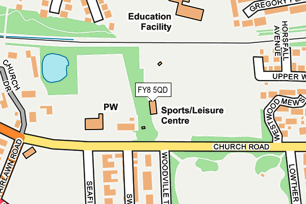
FY8 5QD is located in the Lytham West electoral ward, within the local authority district of Fylde and the English Parliamentary constituency of Fylde. The Sub Integrated Care Board (ICB) Location is NHS Lancashire and South Cumbria ICB - 02M and the police force is Lancashire. This postcode has been in use since January 1980.


GetTheData
Source: OS OpenMap – Local (Ordnance Survey)
Source: OS VectorMap District (Ordnance Survey)
Licence: Open Government Licence (requires attribution)
| Easting | 335822 |
| Northing | 427265 |
| Latitude | 53.737802 |
| Longitude | -2.974436 |
GetTheData
Source: Open Postcode Geo
Licence: Open Government Licence
| Country | England |
| Postcode District | FY8 |
➜ See where FY8 is on a map ➜ Where is Lytham St Anne's? | |
GetTheData
Source: Land Registry Price Paid Data
Licence: Open Government Licence
Elevation or altitude of FY8 5QD as distance above sea level:
| Metres | Feet | |
|---|---|---|
| Elevation | 10m | 33ft |
Elevation is measured from the approximate centre of the postcode, to the nearest point on an OS contour line from OS Terrain 50, which has contour spacing of ten vertical metres.
➜ How high above sea level am I? Find the elevation of your current position using your device's GPS.
GetTheData
Source: Open Postcode Elevation
Licence: Open Government Licence
| Ward | Lytham West |
| Constituency | Fylde |
GetTheData
Source: ONS Postcode Database
Licence: Open Government Licence
| Seafield Road (Church Road) | Lytham | 95m |
| Seafield Road (Church Road) | Lytham | 189m |
| Lowther Terrace (Church Road) | Lytham | 254m |
| Lowther Terrace (Church Road) | Lytham | 279m |
| Lowther Gardens (West Beach) | Lytham | 352m |
| Lytham Station | 0.7km |
| Ansdell & Fairhaven Station | 1.3km |
| Moss Side Station | 3.7km |
GetTheData
Source: NaPTAN
Licence: Open Government Licence
GetTheData
Source: ONS Postcode Database
Licence: Open Government Licence


➜ Get more ratings from the Food Standards Agency
GetTheData
Source: Food Standards Agency
Licence: FSA terms & conditions
| Last Collection | |||
|---|---|---|---|
| Location | Mon-Fri | Sat | Distance |
| 1 Fairlawn Road, Ansdell | 16:00 | 11:45 | 284m |
| 41 Church Road, Lytham | 16:00 | 11:45 | 394m |
| Sedwell Close | 16:00 | 11:30 | 463m |
GetTheData
Source: Dracos
Licence: Creative Commons Attribution-ShareAlike
The below table lists the International Territorial Level (ITL) codes (formerly Nomenclature of Territorial Units for Statistics (NUTS) codes) and Local Administrative Units (LAU) codes for FY8 5QD:
| ITL 1 Code | Name |
|---|---|
| TLD | North West (England) |
| ITL 2 Code | Name |
| TLD4 | Lancashire |
| ITL 3 Code | Name |
| TLD45 | Mid Lancashire |
| LAU 1 Code | Name |
| E07000119 | Fylde |
GetTheData
Source: ONS Postcode Directory
Licence: Open Government Licence
The below table lists the Census Output Area (OA), Lower Layer Super Output Area (LSOA), and Middle Layer Super Output Area (MSOA) for FY8 5QD:
| Code | Name | |
|---|---|---|
| OA | E00126853 | |
| LSOA | E01024991 | Fylde 009B |
| MSOA | E02005211 | Fylde 009 |
GetTheData
Source: ONS Postcode Directory
Licence: Open Government Licence
| FY8 5JN | Church Road | 105m |
| FY8 5QB | Woodville Terrace | 184m |
| FY8 5PX | Church Road | 205m |
| FY8 5QA | Swainson Street | 215m |
| FY8 5PY | Seafield Road | 217m |
| FY8 5NR | St Cuthberts Close | 234m |
| FY8 5NP | Horsfall Avenue | 254m |
| FY8 5QE | Westwood Mews | 260m |
| FY8 5QS | The Leylands | 282m |
| FY8 4QU | South Park | 282m |
GetTheData
Source: Open Postcode Geo; Land Registry Price Paid Data
Licence: Open Government Licence