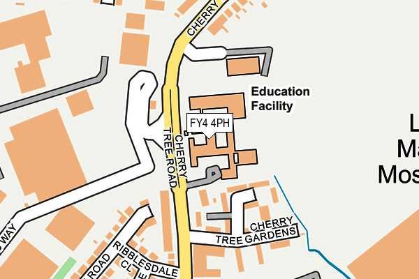
FY4 4PH is located in the Clifton electoral ward, within the unitary authority of Blackpool and the English Parliamentary constituency of Blackpool South. The Sub Integrated Care Board (ICB) Location is NHS Lancashire and South Cumbria ICB - 00R and the police force is Lancashire. This postcode has been in use since January 1980.


GetTheData
Source: OS OpenMap – Local (Ordnance Survey)
Source: OS VectorMap District (Ordnance Survey)
Licence: Open Government Licence (requires attribution)
| Easting | 333249 |
| Northing | 433984 |
| Latitude | 53.797860 |
| Longitude | -3.014893 |
GetTheData
Source: Open Postcode Geo
Licence: Open Government Licence
| Country | England |
| Postcode District | FY4 |
➜ See where FY4 is on a map ➜ Where is Blackpool? | |
GetTheData
Source: Land Registry Price Paid Data
Licence: Open Government Licence
Elevation or altitude of FY4 4PH as distance above sea level:
| Metres | Feet | |
|---|---|---|
| Elevation | 10m | 33ft |
Elevation is measured from the approximate centre of the postcode, to the nearest point on an OS contour line from OS Terrain 50, which has contour spacing of ten vertical metres.
➜ How high above sea level am I? Find the elevation of your current position using your device's GPS.
GetTheData
Source: Open Postcode Elevation
Licence: Open Government Licence
| Ward | Clifton |
| Constituency | Blackpool South |
GetTheData
Source: ONS Postcode Database
Licence: Open Government Licence
| St Georges School (Cherry Tree Road) | Marton | 61m |
| St Georges School (Cherry Tree Road) | Marton | 119m |
| Penrose Avenue (Cherry Tree Road) | Marton | 163m |
| Cherry Tree Road (Penrose Avenue) | Marton | 224m |
| Penrose Avenue (Cherry Tree Road North) | Marton | 226m |
| Blackpool South Station | 2.2km |
| Blackpool Pleasure Beach Station | 2.8km |
| Squires Gate Station | 3.3km |
GetTheData
Source: NaPTAN
Licence: Open Government Licence
GetTheData
Source: ONS Postcode Database
Licence: Open Government Licence


➜ Get more ratings from the Food Standards Agency
GetTheData
Source: Food Standards Agency
Licence: FSA terms & conditions
| Last Collection | |||
|---|---|---|---|
| Location | Mon-Fri | Sat | Distance |
| Cherry Tree Gardens | 16:15 | 12:45 | 126m |
| Asda | 17:00 | 12:30 | 194m |
| 7 Cherry Tree Road North | 17:00 | 12:15 | 446m |
GetTheData
Source: Dracos
Licence: Creative Commons Attribution-ShareAlike
The below table lists the International Territorial Level (ITL) codes (formerly Nomenclature of Territorial Units for Statistics (NUTS) codes) and Local Administrative Units (LAU) codes for FY4 4PH:
| ITL 1 Code | Name |
|---|---|
| TLD | North West (England) |
| ITL 2 Code | Name |
| TLD4 | Lancashire |
| ITL 3 Code | Name |
| TLD42 | Blackpool |
| LAU 1 Code | Name |
| E06000009 | Blackpool |
GetTheData
Source: ONS Postcode Directory
Licence: Open Government Licence
The below table lists the Census Output Area (OA), Lower Layer Super Output Area (LSOA), and Middle Layer Super Output Area (MSOA) for FY4 4PH:
| Code | Name | |
|---|---|---|
| OA | E00063952 | |
| LSOA | E01012688 | Blackpool 014C |
| MSOA | E02002646 | Blackpool 014 |
GetTheData
Source: ONS Postcode Directory
Licence: Open Government Licence
| FY4 4PY | Cherry Tree Gardens | 109m |
| FY4 4PX | Cherry Tree Gardens | 178m |
| FY4 4NR | Ribblesdale Close | 183m |
| FY4 4PG | Cherry Tree Road | 196m |
| FY4 4PQ | Cherry Tree Road | 237m |
| FY4 4NP | Wasdale Road | 241m |
| FY4 4JX | Penrose Avenue | 243m |
| FY4 4LG | Winton Avenue | 250m |
| FY4 4NS | Cherry Tree Road | 262m |
| FY4 4PT | Cherry Tree Road | 271m |
GetTheData
Source: Open Postcode Geo; Land Registry Price Paid Data
Licence: Open Government Licence