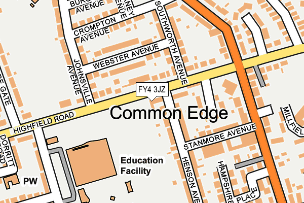
FY4 3JZ lies on Highfield Road in Blackpool. FY4 3JZ is located in the Highfield electoral ward, within the unitary authority of Blackpool and the English Parliamentary constituency of Blackpool South. The Sub Integrated Care Board (ICB) Location is NHS Lancashire and South Cumbria ICB - 00R and the police force is Lancashire. This postcode has been in use since January 1980.


GetTheData
Source: OS OpenMap – Local (Ordnance Survey)
Source: OS VectorMap District (Ordnance Survey)
Licence: Open Government Licence (requires attribution)
| Easting | 332382 |
| Northing | 432970 |
| Latitude | 53.788635 |
| Longitude | -3.027830 |
GetTheData
Source: Open Postcode Geo
Licence: Open Government Licence
| Street | Highfield Road |
| Town/City | Blackpool |
| Country | England |
| Postcode District | FY4 |
➜ See where FY4 is on a map ➜ Where is Blackpool? | |
GetTheData
Source: Land Registry Price Paid Data
Licence: Open Government Licence
Elevation or altitude of FY4 3JZ as distance above sea level:
| Metres | Feet | |
|---|---|---|
| Elevation | 10m | 33ft |
Elevation is measured from the approximate centre of the postcode, to the nearest point on an OS contour line from OS Terrain 50, which has contour spacing of ten vertical metres.
➜ How high above sea level am I? Find the elevation of your current position using your device's GPS.
GetTheData
Source: Open Postcode Elevation
Licence: Open Government Licence
| Ward | Highfield |
| Constituency | Blackpool South |
GetTheData
Source: ONS Postcode Database
Licence: Open Government Licence
| Highfield Hotel (Highfield Road) | Highfield | 94m |
| Highfield Hotel (Highfield Road) | Highfield | 130m |
| Highfield High School (Highfield Road) | Highfield | 140m |
| Highfield High School (Highfield Road) | Highfield | 166m |
| Highfield Hotel (Common Edge Road) | Highfield | 171m |
| Blackpool Pleasure Beach Station | 1.7km |
| Blackpool South Station | 1.8km |
| Squires Gate Station | 1.9km |
GetTheData
Source: NaPTAN
Licence: Open Government Licence
| Percentage of properties with Next Generation Access | 100.0% |
| Percentage of properties with Superfast Broadband | 100.0% |
| Percentage of properties with Ultrafast Broadband | 100.0% |
| Percentage of properties with Full Fibre Broadband | 0.0% |
Superfast Broadband is between 30Mbps and 300Mbps
Ultrafast Broadband is > 300Mbps
| Percentage of properties unable to receive 2Mbps | 0.0% |
| Percentage of properties unable to receive 5Mbps | 0.0% |
| Percentage of properties unable to receive 10Mbps | 0.0% |
| Percentage of properties unable to receive 30Mbps | 0.0% |
GetTheData
Source: Ofcom
Licence: Ofcom Terms of Use (requires attribution)
GetTheData
Source: ONS Postcode Database
Licence: Open Government Licence


➜ Get more ratings from the Food Standards Agency
GetTheData
Source: Food Standards Agency
Licence: FSA terms & conditions
| Last Collection | |||
|---|---|---|---|
| Location | Mon-Fri | Sat | Distance |
| Burgess Avenue | 17:00 | 11:45 | 256m |
| Highfield School | 17:00 | 11:45 | 258m |
| 36 Lostock Gardens | 16:30 | 11:45 | 424m |
GetTheData
Source: Dracos
Licence: Creative Commons Attribution-ShareAlike
The below table lists the International Territorial Level (ITL) codes (formerly Nomenclature of Territorial Units for Statistics (NUTS) codes) and Local Administrative Units (LAU) codes for FY4 3JZ:
| ITL 1 Code | Name |
|---|---|
| TLD | North West (England) |
| ITL 2 Code | Name |
| TLD4 | Lancashire |
| ITL 3 Code | Name |
| TLD42 | Blackpool |
| LAU 1 Code | Name |
| E06000009 | Blackpool |
GetTheData
Source: ONS Postcode Directory
Licence: Open Government Licence
The below table lists the Census Output Area (OA), Lower Layer Super Output Area (LSOA), and Middle Layer Super Output Area (MSOA) for FY4 3JZ:
| Code | Name | |
|---|---|---|
| OA | E00064196 | |
| LSOA | E01012729 | Blackpool 018B |
| MSOA | E02002650 | Blackpool 018 |
GetTheData
Source: ONS Postcode Directory
Licence: Open Government Licence
| FY4 3JX | Highfield Road | 62m |
| FY4 3LA | Highfield Road | 76m |
| FY4 3LJ | Webster Avenue | 86m |
| FY4 3LL | Webster Avenue | 106m |
| FY4 3LG | Lowstead Place | 118m |
| FY4 3LH | Southworth Avenue | 136m |
| FY4 3LU | Stanmore Avenue | 145m |
| FY4 3LQ | Crompton Avenue | 164m |
| FY4 3LZ | Henson Avenue | 177m |
| FY4 3LY | Henson Avenue | 185m |
GetTheData
Source: Open Postcode Geo; Land Registry Price Paid Data
Licence: Open Government Licence