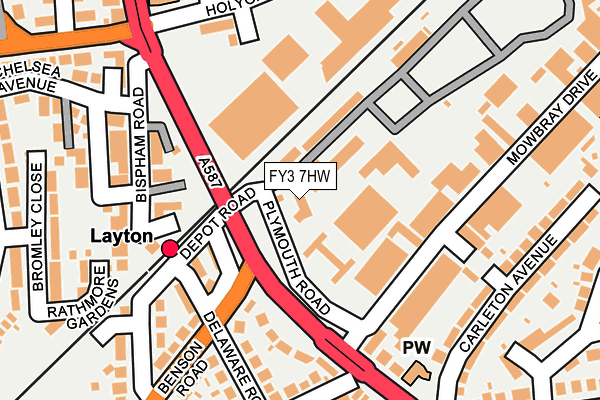
FY3 7HW is located in the Layton electoral ward, within the unitary authority of Blackpool and the English Parliamentary constituency of Blackpool North and Cleveleys. The Sub Integrated Care Board (ICB) Location is NHS Lancashire and South Cumbria ICB - 00R and the police force is Lancashire. This postcode has been in use since June 2001.


GetTheData
Source: OS OpenMap – Local (Ordnance Survey)
Source: OS VectorMap District (Ordnance Survey)
Licence: Open Government Licence (requires attribution)
| Easting | 332300 |
| Northing | 438000 |
| Latitude | 53.833841 |
| Longitude | -3.030178 |
GetTheData
Source: Open Postcode Geo
Licence: Open Government Licence
| Country | England |
| Postcode District | FY3 |
➜ See where FY3 is on a map ➜ Where is Blackpool? | |
GetTheData
Source: Land Registry Price Paid Data
Licence: Open Government Licence
Elevation or altitude of FY3 7HW as distance above sea level:
| Metres | Feet | |
|---|---|---|
| Elevation | 20m | 66ft |
Elevation is measured from the approximate centre of the postcode, to the nearest point on an OS contour line from OS Terrain 50, which has contour spacing of ten vertical metres.
➜ How high above sea level am I? Find the elevation of your current position using your device's GPS.
GetTheData
Source: Open Postcode Elevation
Licence: Open Government Licence
| Ward | Layton |
| Constituency | Blackpool North And Cleveleys |
GetTheData
Source: ONS Postcode Database
Licence: Open Government Licence
| Bispham Road (Benson Road) | North Shore | 38m |
| Benson Road (Bispham Road) | North Shore | 118m |
| Benson Road (Plymouth Road) | Holyoake | 145m |
| Meyler Avenue (Poulton Road) | North Shore | 151m |
| Meyler Avenue (Poulton Road) | Wades Farm | 175m |
| Layton (Lancs) Station | 0.2km |
| Blackpool North Station | 1.8km |
| Poulton-le-Fylde Station | 3.1km |
GetTheData
Source: NaPTAN
Licence: Open Government Licence
GetTheData
Source: ONS Postcode Database
Licence: Open Government Licence


➜ Get more ratings from the Food Standards Agency
GetTheData
Source: Food Standards Agency
Licence: FSA terms & conditions
| Last Collection | |||
|---|---|---|---|
| Location | Mon-Fri | Sat | Distance |
| Poulton Road | 17:15 | 12:15 | 363m |
| Pelham Avenue | 17:15 | 11:30 | 380m |
| Holyoake Avenue | 17:30 | 11:15 | 397m |
GetTheData
Source: Dracos
Licence: Creative Commons Attribution-ShareAlike
The below table lists the International Territorial Level (ITL) codes (formerly Nomenclature of Territorial Units for Statistics (NUTS) codes) and Local Administrative Units (LAU) codes for FY3 7HW:
| ITL 1 Code | Name |
|---|---|
| TLD | North West (England) |
| ITL 2 Code | Name |
| TLD4 | Lancashire |
| ITL 3 Code | Name |
| TLD42 | Blackpool |
| LAU 1 Code | Name |
| E06000009 | Blackpool |
GetTheData
Source: ONS Postcode Directory
Licence: Open Government Licence
The below table lists the Census Output Area (OA), Lower Layer Super Output Area (LSOA), and Middle Layer Super Output Area (MSOA) for FY3 7HW:
| Code | Name | |
|---|---|---|
| OA | E00064079 | |
| LSOA | E01012711 | Blackpool 005B |
| MSOA | E02002637 | Blackpool 005 |
GetTheData
Source: ONS Postcode Directory
Licence: Open Government Licence
| FY3 7HQ | Bispham Road | 24m |
| FY3 7JU | Oregon Avenue | 76m |
| FY3 7HL | Hoo Hill Lane | 77m |
| FY3 7HP | Benson Road | 82m |
| FY3 7FF | Bridge Close | 94m |
| FY3 7JX | Delaware Road | 94m |
| FY3 7JY | Delaware Road | 105m |
| FY3 7JZ | Delaware Road | 108m |
| FY3 7DS | Poulton Road | 132m |
| FY2 0RZ | Rathmore Gardens | 137m |
GetTheData
Source: Open Postcode Geo; Land Registry Price Paid Data
Licence: Open Government Licence