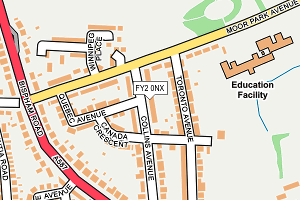
FY2 0NX lies on Collins Avenue in Blackpool. FY2 0NX is located in the Greenlands electoral ward, within the unitary authority of Blackpool and the English Parliamentary constituency of Blackpool North and Cleveleys. The Sub Integrated Care Board (ICB) Location is NHS Lancashire and South Cumbria ICB - 00R and the police force is Lancashire. This postcode has been in use since January 1980.


GetTheData
Source: OS OpenMap – Local (Ordnance Survey)
Source: OS VectorMap District (Ordnance Survey)
Licence: Open Government Licence (requires attribution)
| Easting | 332151 |
| Northing | 439340 |
| Latitude | 53.845849 |
| Longitude | -3.032743 |
GetTheData
Source: Open Postcode Geo
Licence: Open Government Licence
| Street | Collins Avenue |
| Town/City | Blackpool |
| Country | England |
| Postcode District | FY2 |
➜ See where FY2 is on a map ➜ Where is Blackpool? | |
GetTheData
Source: Land Registry Price Paid Data
Licence: Open Government Licence
Elevation or altitude of FY2 0NX as distance above sea level:
| Metres | Feet | |
|---|---|---|
| Elevation | 10m | 33ft |
Elevation is measured from the approximate centre of the postcode, to the nearest point on an OS contour line from OS Terrain 50, which has contour spacing of ten vertical metres.
➜ How high above sea level am I? Find the elevation of your current position using your device's GPS.
GetTheData
Source: Open Postcode Elevation
Licence: Open Government Licence
| Ward | Greenlands |
| Constituency | Blackpool North And Cleveleys |
GetTheData
Source: ONS Postcode Database
Licence: Open Government Licence
| Winnipeg Place (Moorpark Avenue) | Moor Park | 163m |
| Winnipeg Place (Moor Park Avenue) | Moor Park | 169m |
| The Squirrel (Bispham Road) | Squirrel | 235m |
| Bispham Rd (Moor Park Avenue) | Moor Park | 238m |
| The Squirrel (Bispham Road) | Squirrel | 241m |
| Cavendish Road (Blackpool Tramway) (Cavendish Road) | North Shore | 1,374m |
| Bispham (Blackpool Tramway) (Red Bank Road) | Bispham | 1,419m |
| Lowther Avenue (Blackpool Tramway) (Lowther Avenue) | North Shore | 1,486m |
| Sandhurst Avenue (Blackpool Tramway) (Sandhurst Avenue) | Bispham | 1,520m |
| Cabin (Blackpool Tramway) (Knowle Avenue) | North Shore | 1,688m |
| Layton (Lancs) Station | 1.2km |
| Poulton-le-Fylde Station | 2.8km |
| Blackpool North Station | 2.9km |
GetTheData
Source: NaPTAN
Licence: Open Government Licence
| Percentage of properties with Next Generation Access | 100.0% |
| Percentage of properties with Superfast Broadband | 100.0% |
| Percentage of properties with Ultrafast Broadband | 100.0% |
| Percentage of properties with Full Fibre Broadband | 0.0% |
Superfast Broadband is between 30Mbps and 300Mbps
Ultrafast Broadband is > 300Mbps
| Median download speed | 60.5Mbps |
| Average download speed | 74.3Mbps |
| Maximum download speed | 350.00Mbps |
| Median upload speed | 10.0Mbps |
| Average upload speed | 10.8Mbps |
| Maximum upload speed | 20.00Mbps |
| Percentage of properties unable to receive 2Mbps | 0.0% |
| Percentage of properties unable to receive 5Mbps | 0.0% |
| Percentage of properties unable to receive 10Mbps | 0.0% |
| Percentage of properties unable to receive 30Mbps | 0.0% |
GetTheData
Source: Ofcom
Licence: Ofcom Terms of Use (requires attribution)
Estimated total energy consumption in FY2 0NX by fuel type, 2015.
| Consumption (kWh) | 353,934 |
|---|---|
| Meter count | 29 |
| Mean (kWh/meter) | 12,205 |
| Median (kWh/meter) | 11,389 |
| Consumption (kWh) | 101,792 |
|---|---|
| Meter count | 24 |
| Mean (kWh/meter) | 4,241 |
| Median (kWh/meter) | 3,328 |
GetTheData
Source: Postcode level gas estimates: 2015 (experimental)
Source: Postcode level electricity estimates: 2015 (experimental)
Licence: Open Government Licence
GetTheData
Source: ONS Postcode Database
Licence: Open Government Licence


➜ Get more ratings from the Food Standards Agency
GetTheData
Source: Food Standards Agency
Licence: FSA terms & conditions
| Last Collection | |||
|---|---|---|---|
| Location | Mon-Fri | Sat | Distance |
| 5 Moor Park Avenue | 17:15 | 11:15 | 203m |
| Linden Place | 17:15 | 11:15 | 416m |
| 36 Kylemore Avenue | 16:45 | 12:45 | 466m |
GetTheData
Source: Dracos
Licence: Creative Commons Attribution-ShareAlike
The below table lists the International Territorial Level (ITL) codes (formerly Nomenclature of Territorial Units for Statistics (NUTS) codes) and Local Administrative Units (LAU) codes for FY2 0NX:
| ITL 1 Code | Name |
|---|---|
| TLD | North West (England) |
| ITL 2 Code | Name |
| TLD4 | Lancashire |
| ITL 3 Code | Name |
| TLD42 | Blackpool |
| LAU 1 Code | Name |
| E06000009 | Blackpool |
GetTheData
Source: ONS Postcode Directory
Licence: Open Government Licence
The below table lists the Census Output Area (OA), Lower Layer Super Output Area (LSOA), and Middle Layer Super Output Area (MSOA) for FY2 0NX:
| Code | Name | |
|---|---|---|
| OA | E00063983 | |
| LSOA | E01012692 | Blackpool 004C |
| MSOA | E02002636 | Blackpool 004 |
GetTheData
Source: ONS Postcode Directory
Licence: Open Government Licence
| FY2 0NY | Canada Crescent | 73m |
| FY2 0PD | Toronto Avenue | 79m |
| FY2 0NT | Canada Crescent | 118m |
| FY2 0ND | Moor Park Avenue | 120m |
| FY2 0NU | Quebec Avenue | 123m |
| FY2 0LY | Moor Park Avenue | 136m |
| FY2 0LT | Moor Park Avenue | 146m |
| FY2 0LU | 161m | |
| FY2 0NS | Collins Avenue | 170m |
| FY2 0PB | Toronto Avenue | 188m |
GetTheData
Source: Open Postcode Geo; Land Registry Price Paid Data
Licence: Open Government Licence