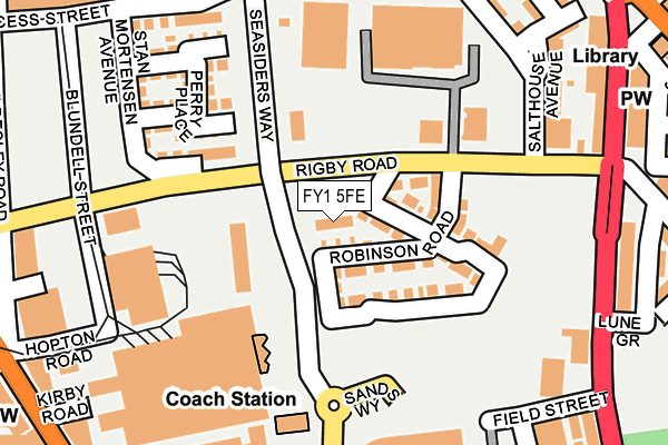
FY1 5FE lies on Garrett Gardens in Blackpool. FY1 5FE is located in the Bloomfield electoral ward, within the unitary authority of Blackpool and the English Parliamentary constituency of Blackpool South. The Sub Integrated Care Board (ICB) Location is NHS Lancashire and South Cumbria ICB - 00R and the police force is Lancashire. This postcode has been in use since November 2015.


GetTheData
Source: OS OpenMap – Local (Ordnance Survey)
Source: OS VectorMap District (Ordnance Survey)
Licence: Open Government Licence (requires attribution)
| Easting | 330981 |
| Northing | 435076 |
| Latitude | 53.807391 |
| Longitude | -3.049561 |
GetTheData
Source: Open Postcode Geo
Licence: Open Government Licence
| Street | Garrett Gardens |
| Town/City | Blackpool |
| Country | England |
| Postcode District | FY1 |
➜ See where FY1 is on a map ➜ Where is Blackpool? | |
GetTheData
Source: Land Registry Price Paid Data
Licence: Open Government Licence
Elevation or altitude of FY1 5FE as distance above sea level:
| Metres | Feet | |
|---|---|---|
| Elevation | 10m | 33ft |
Elevation is measured from the approximate centre of the postcode, to the nearest point on an OS contour line from OS Terrain 50, which has contour spacing of ten vertical metres.
➜ How high above sea level am I? Find the elevation of your current position using your device's GPS.
GetTheData
Source: Open Postcode Elevation
Licence: Open Government Licence
| Ward | Bloomfield |
| Constituency | Blackpool South |
GetTheData
Source: ONS Postcode Database
Licence: Open Government Licence
| Blundell Street | Promenade | 228m |
| Rigby Road (Central Drive) | Central | 240m |
| Rigby Road (Central Drive) | Central | 251m |
| Gymnasium (Central Drive) | Central | 309m |
| The Manchester (Lytham Road) | Promenade | 331m |
| Manchester Square (Blackpool Tramway) (Promenade) | Bloomfield | 403m |
| Central Pier (Blackpool Tramway) (Promenade) | Bloomfield | 638m |
| St Chad's (Blackpool Tramway) (St Chads Road) | Bloomfield | 679m |
| Tower (Blackpool Tramway) (Promenade) | Blackpool | 905m |
| Waterloo Road (Blackpool Tramway) (Waterloo Road) | Bloomfield | 1,016m |
| Blackpool South Station | 1km |
| Blackpool North Station | 1.6km |
| Blackpool Pleasure Beach Station | 2.2km |
GetTheData
Source: NaPTAN
Licence: Open Government Licence
| Percentage of properties with Next Generation Access | 100.0% |
| Percentage of properties with Superfast Broadband | 100.0% |
| Percentage of properties with Ultrafast Broadband | 0.0% |
| Percentage of properties with Full Fibre Broadband | 0.0% |
Superfast Broadband is between 30Mbps and 300Mbps
Ultrafast Broadband is > 300Mbps
| Percentage of properties unable to receive 2Mbps | 0.0% |
| Percentage of properties unable to receive 5Mbps | 0.0% |
| Percentage of properties unable to receive 10Mbps | 0.0% |
| Percentage of properties unable to receive 30Mbps | 0.0% |
GetTheData
Source: Ofcom
Licence: Ofcom Terms of Use (requires attribution)
Estimated total energy consumption in FY1 5FE by fuel type, 2015.
| Consumption (kWh) | 4,681 |
|---|---|
| Meter count | 6 |
| Mean (kWh/meter) | 780 |
| Median (kWh/meter) | 357 |
GetTheData
Source: Postcode level gas estimates: 2015 (experimental)
Source: Postcode level electricity estimates: 2015 (experimental)
Licence: Open Government Licence
GetTheData
Source: ONS Postcode Database
Licence: Open Government Licence


➜ Get more ratings from the Food Standards Agency
GetTheData
Source: Food Standards Agency
Licence: FSA terms & conditions
| Last Collection | |||
|---|---|---|---|
| Location | Mon-Fri | Sat | Distance |
| Manchester Square | 16:30 | 12:45 | 300m |
| Central Drive South | 16:30 | 11:30 | 305m |
| Tyldeley Road | 17:00 | 12:45 | 362m |
GetTheData
Source: Dracos
Licence: Creative Commons Attribution-ShareAlike
The below table lists the International Territorial Level (ITL) codes (formerly Nomenclature of Territorial Units for Statistics (NUTS) codes) and Local Administrative Units (LAU) codes for FY1 5FE:
| ITL 1 Code | Name |
|---|---|
| TLD | North West (England) |
| ITL 2 Code | Name |
| TLD4 | Lancashire |
| ITL 3 Code | Name |
| TLD42 | Blackpool |
| LAU 1 Code | Name |
| E06000009 | Blackpool |
GetTheData
Source: ONS Postcode Directory
Licence: Open Government Licence
The below table lists the Census Output Area (OA), Lower Layer Super Output Area (LSOA), and Middle Layer Super Output Area (MSOA) for FY1 5FE:
| Code | Name | |
|---|---|---|
| OA | E00063883 | |
| LSOA | E01012674 | Blackpool 013C |
| MSOA | E02002645 | Blackpool 013 |
GetTheData
Source: ONS Postcode Directory
Licence: Open Government Licence
| FY1 5FG | Robinson Road | 53m |
| FY1 5DE | Rigby Road | 63m |
| FY1 5FJ | Sir Stanley Matthews Way East | 87m |
| FY1 5FB | Taylor Terrace | 136m |
| FY1 5FD | Perry Place | 198m |
| FY1 5EQ | Princess Street | 212m |
| FY1 5FA | Stan Mortensen Avenue | 219m |
| FY1 5ET | Kent Road | 242m |
| FY1 6EE | Lonsdale Road | 247m |
| FY1 5EN | Salthouse Avenue | 248m |
GetTheData
Source: Open Postcode Geo; Land Registry Price Paid Data
Licence: Open Government Licence