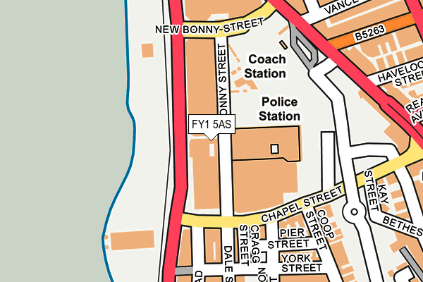
FY1 5AS is located in the Talbot electoral ward, within the unitary authority of Blackpool and the English Parliamentary constituency of Blackpool South. The Sub Integrated Care Board (ICB) Location is NHS Lancashire and South Cumbria ICB - 00R and the police force is Lancashire. This postcode has been in use since January 1980.


GetTheData
Source: OS OpenMap – Local (Ordnance Survey)
Source: OS VectorMap District (Ordnance Survey)
Licence: Open Government Licence (requires attribution)
| Easting | 330652 |
| Northing | 435624 |
| Latitude | 53.812257 |
| Longitude | -3.054683 |
GetTheData
Source: Open Postcode Geo
Licence: Open Government Licence
| Country | England |
| Postcode District | FY1 |
➜ See where FY1 is on a map ➜ Where is Blackpool? | |
GetTheData
Source: Land Registry Price Paid Data
Licence: Open Government Licence
Elevation or altitude of FY1 5AS as distance above sea level:
| Metres | Feet | |
|---|---|---|
| Elevation | 10m | 33ft |
Elevation is measured from the approximate centre of the postcode, to the nearest point on an OS contour line from OS Terrain 50, which has contour spacing of ten vertical metres.
➜ How high above sea level am I? Find the elevation of your current position using your device's GPS.
GetTheData
Source: Open Postcode Elevation
Licence: Open Government Licence
| Ward | Talbot |
| Constituency | Blackpool South |
GetTheData
Source: ONS Postcode Database
Licence: Open Government Licence
| New Bonny Street | Promenade | 160m |
| Central Pier (Promenade) | Promenade | 198m |
| Central Coach Station (Central Drive) | Blackpool Town Centre | 213m |
| Promenade | Promenade | 234m |
| Central Pier (Promenade) | Promenade | 249m |
| Central Pier (Blackpool Tramway) (Promenade) | Bloomfield | 72m |
| Tower (Blackpool Tramway) (Promenade) | Blackpool | 272m |
| Manchester Square (Blackpool Tramway) (Promenade) | Bloomfield | 461m |
| North Pier (Blackpool Tramway) (Talbot Road) | Blackpool | 719m |
| St Chad's (Blackpool Tramway) (St Chads Road) | Bloomfield | 1,096m |
| Blackpool North Station | 1.1km |
| Blackpool South Station | 1.6km |
| Blackpool Pleasure Beach Station | 2.7km |
GetTheData
Source: NaPTAN
Licence: Open Government Licence
GetTheData
Source: ONS Postcode Database
Licence: Open Government Licence


➜ Get more ratings from the Food Standards Agency
GetTheData
Source: Food Standards Agency
Licence: FSA terms & conditions
| Last Collection | |||
|---|---|---|---|
| Location | Mon-Fri | Sat | Distance |
| 23 Chapel Street | 16:45 | 12:45 | 143m |
| Revoe Post Office | 17:45 | 11:30 | 319m |
| 1 Charnley Road | 16:30 | 11:15 | 365m |
GetTheData
Source: Dracos
Licence: Creative Commons Attribution-ShareAlike
The below table lists the International Territorial Level (ITL) codes (formerly Nomenclature of Territorial Units for Statistics (NUTS) codes) and Local Administrative Units (LAU) codes for FY1 5AS:
| ITL 1 Code | Name |
|---|---|
| TLD | North West (England) |
| ITL 2 Code | Name |
| TLD4 | Lancashire |
| ITL 3 Code | Name |
| TLD42 | Blackpool |
| LAU 1 Code | Name |
| E06000009 | Blackpool |
GetTheData
Source: ONS Postcode Directory
Licence: Open Government Licence
The below table lists the Census Output Area (OA), Lower Layer Super Output Area (LSOA), and Middle Layer Super Output Area (MSOA) for FY1 5AS:
| Code | Name | |
|---|---|---|
| OA | E00064223 | |
| LSOA | E01012736 | Blackpool 010D |
| MSOA | E02002642 | Blackpool 010 |
GetTheData
Source: ONS Postcode Directory
Licence: Open Government Licence
| FY1 5AF | Dale Street | 152m |
| FY1 5AP | Cragg Street | 158m |
| FY1 5AW | Chapel Street | 158m |
| FY1 5AH | Pier Street | 195m |
| FY1 5BS | Bickerstaffe Street | 219m |
| FY1 5QA | Central Drive | 222m |
| FY1 5AQ | York Street | 224m |
| FY1 5PZ | Central Drive | 226m |
| FY1 5AD | Foxhall Road | 233m |
| FY1 5QB | Central Drive | 233m |
GetTheData
Source: Open Postcode Geo; Land Registry Price Paid Data
Licence: Open Government Licence