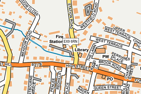
EX9 6RN lies on Station Road in Budleigh Salterton. EX9 6RN is located in the Budleigh & Raleigh electoral ward, within the local authority district of East Devon and the English Parliamentary constituency of East Devon. The Sub Integrated Care Board (ICB) Location is NHS Devon ICB - 15N and the police force is Devon & Cornwall. This postcode has been in use since January 1980.


GetTheData
Source: OS OpenMap – Local (Ordnance Survey)
Source: OS VectorMap District (Ordnance Survey)
Licence: Open Government Licence (requires attribution)
| Easting | 306133 |
| Northing | 82033 |
| Latitude | 50.630412 |
| Longitude | -3.328546 |
GetTheData
Source: Open Postcode Geo
Licence: Open Government Licence
| Street | Station Road |
| Town/City | Budleigh Salterton |
| Country | England |
| Postcode District | EX9 |
➜ See where EX9 is on a map ➜ Where is Budleigh Salterton? | |
GetTheData
Source: Land Registry Price Paid Data
Licence: Open Government Licence
Elevation or altitude of EX9 6RN as distance above sea level:
| Metres | Feet | |
|---|---|---|
| Elevation | 20m | 66ft |
Elevation is measured from the approximate centre of the postcode, to the nearest point on an OS contour line from OS Terrain 50, which has contour spacing of ten vertical metres.
➜ How high above sea level am I? Find the elevation of your current position using your device's GPS.
GetTheData
Source: Open Postcode Elevation
Licence: Open Government Licence
| Ward | Budleigh & Raleigh |
| Constituency | East Devon |
GetTheData
Source: ONS Postcode Database
Licence: Open Government Licence
| Library (Station Road) | Budleigh Salterton | 34m |
| Public Hall (Station Road) | Budleigh Salterton | 48m |
| Westbourne Terrace (West Hill) | Little Knowle | 153m |
| Meadow Road (West Hill) | Little Knowle | 177m |
| Moor Lane (Station Road) | Budleigh Salterton | 268m |
GetTheData
Source: NaPTAN
Licence: Open Government Licence
| Percentage of properties with Next Generation Access | 100.0% |
| Percentage of properties with Superfast Broadband | 100.0% |
| Percentage of properties with Ultrafast Broadband | 0.0% |
| Percentage of properties with Full Fibre Broadband | 0.0% |
Superfast Broadband is between 30Mbps and 300Mbps
Ultrafast Broadband is > 300Mbps
| Percentage of properties unable to receive 2Mbps | 0.0% |
| Percentage of properties unable to receive 5Mbps | 0.0% |
| Percentage of properties unable to receive 10Mbps | 0.0% |
| Percentage of properties unable to receive 30Mbps | 0.0% |
GetTheData
Source: Ofcom
Licence: Ofcom Terms of Use (requires attribution)
GetTheData
Source: ONS Postcode Database
Licence: Open Government Licence
➜ Get more ratings from the Food Standards Agency
GetTheData
Source: Food Standards Agency
Licence: FSA terms & conditions
| Last Collection | |||
|---|---|---|---|
| Location | Mon-Fri | Sat | Distance |
| Station Road | 18:15 | 12:00 | 288m |
| Fore Street | 17:45 | 11:45 | 471m |
| Bedlands Lane | 17:45 | 11:45 | 887m |
GetTheData
Source: Dracos
Licence: Creative Commons Attribution-ShareAlike
The below table lists the International Territorial Level (ITL) codes (formerly Nomenclature of Territorial Units for Statistics (NUTS) codes) and Local Administrative Units (LAU) codes for EX9 6RN:
| ITL 1 Code | Name |
|---|---|
| TLK | South West (England) |
| ITL 2 Code | Name |
| TLK4 | Devon |
| ITL 3 Code | Name |
| TLK43 | Devon CC |
| LAU 1 Code | Name |
| E07000040 | East Devon |
GetTheData
Source: ONS Postcode Directory
Licence: Open Government Licence
The below table lists the Census Output Area (OA), Lower Layer Super Output Area (LSOA), and Middle Layer Super Output Area (MSOA) for EX9 6RN:
| Code | Name | |
|---|---|---|
| OA | E00100684 | |
| LSOA | E01019896 | East Devon 017C |
| MSOA | E02004145 | East Devon 017 |
GetTheData
Source: ONS Postcode Directory
Licence: Open Government Licence
| EX9 6RJ | Station Road | 51m |
| EX9 6RH | Station Road | 55m |
| EX9 6ND | Palmer Court | 70m |
| EX9 6BW | West Hill | 72m |
| EX9 6LW | High Street | 80m |
| EX9 6RQ | Green Mews | 91m |
| EX9 6LE | High Street | 105m |
| EX9 6JJ | Palmer Mews | 130m |
| EX9 6BS | West Hill | 154m |
| EX9 6JR | Cliff Road | 161m |
GetTheData
Source: Open Postcode Geo; Land Registry Price Paid Data
Licence: Open Government Licence