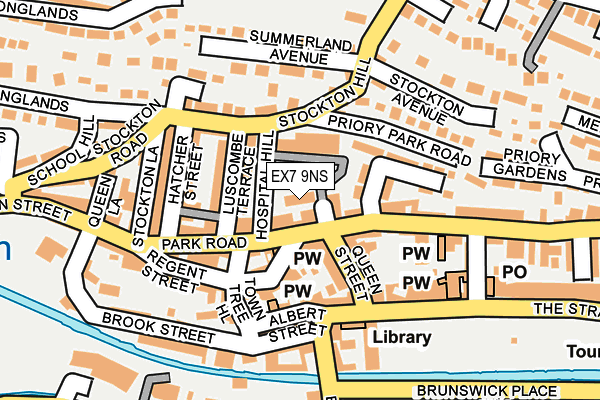
EX7 9NS is located in the Dawlish North East electoral ward, within the local authority district of Teignbridge and the English Parliamentary constituency of Newton Abbot. The Sub Integrated Care Board (ICB) Location is NHS Devon ICB - 15N and the police force is Devon & Cornwall. This postcode has been in use since December 2000.


GetTheData
Source: OS OpenMap – Local (Ordnance Survey)
Source: OS VectorMap District (Ordnance Survey)
Licence: Open Government Licence (requires attribution)
| Easting | 295826 |
| Northing | 76830 |
| Latitude | 50.581873 |
| Longitude | -3.472779 |
GetTheData
Source: Open Postcode Geo
Licence: Open Government Licence
| Country | England |
| Postcode District | EX7 |
➜ See where EX7 is on a map ➜ Where is Dawlish? | |
GetTheData
Source: Land Registry Price Paid Data
Licence: Open Government Licence
Elevation or altitude of EX7 9NS as distance above sea level:
| Metres | Feet | |
|---|---|---|
| Elevation | 20m | 66ft |
Elevation is measured from the approximate centre of the postcode, to the nearest point on an OS contour line from OS Terrain 50, which has contour spacing of ten vertical metres.
➜ How high above sea level am I? Find the elevation of your current position using your device's GPS.
GetTheData
Source: Open Postcode Elevation
Licence: Open Government Licence
| Ward | Dawlish North East |
| Constituency | Newton Abbot |
GetTheData
Source: ONS Postcode Database
Licence: Open Government Licence
| Queen Street (King Street) | Dawlish | 92m |
| Queen Street | Dawlish | 141m |
| Brunswick Place (Alexander Road) | Dawlish | 161m |
| Central Hall (Old Town Street) | Dawlish | 192m |
| Central Hall (Old Town Street) | Dawlish | 213m |
| Dawlish Station | 0.6km |
| Dawlish Warren Station | 2.8km |
| Teignmouth Station | 4.1km |
GetTheData
Source: NaPTAN
Licence: Open Government Licence
GetTheData
Source: ONS Postcode Database
Licence: Open Government Licence


➜ Get more ratings from the Food Standards Agency
GetTheData
Source: Food Standards Agency
Licence: FSA terms & conditions
| Last Collection | |||
|---|---|---|---|
| Location | Mon-Fri | Sat | Distance |
| Church Street | 17:30 | 12:15 | 97m |
| Dawlish Post Office | 18:30 | 12:30 | 248m |
| High Street | 18:00 | 12:00 | 321m |
GetTheData
Source: Dracos
Licence: Creative Commons Attribution-ShareAlike
The below table lists the International Territorial Level (ITL) codes (formerly Nomenclature of Territorial Units for Statistics (NUTS) codes) and Local Administrative Units (LAU) codes for EX7 9NS:
| ITL 1 Code | Name |
|---|---|
| TLK | South West (England) |
| ITL 2 Code | Name |
| TLK4 | Devon |
| ITL 3 Code | Name |
| TLK43 | Devon CC |
| LAU 1 Code | Name |
| E07000045 | Teignbridge |
GetTheData
Source: ONS Postcode Directory
Licence: Open Government Licence
The below table lists the Census Output Area (OA), Lower Layer Super Output Area (LSOA), and Middle Layer Super Output Area (MSOA) for EX7 9NS:
| Code | Name | |
|---|---|---|
| OA | E00102472 | |
| LSOA | E01020228 | Teignbridge 006A |
| MSOA | E02004206 | Teignbridge 006 |
GetTheData
Source: ONS Postcode Directory
Licence: Open Government Licence
| EX7 9LH | Park Road | 25m |
| EX7 9LQ | Park Road | 40m |
| EX7 9LF | Princes Street | 41m |
| EX7 9LG | King Street | 47m |
| EX7 9LY | Luscombe Terrace | 59m |
| EX7 9LJ | Park Road | 60m |
| EX7 9LE | Regent Street | 77m |
| EX7 9NA | Hatcher Street | 78m |
| EX7 9JZ | Albert Cottages | 79m |
| EX7 9LD | Town Tree Hill | 84m |
GetTheData
Source: Open Postcode Geo; Land Registry Price Paid Data
Licence: Open Government Licence