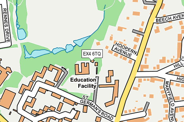
EX4 6TQ is located in the Duryard and St James electoral ward, within the local authority district of Exeter and the English Parliamentary constituency of Exeter. The Sub Integrated Care Board (ICB) Location is NHS Devon ICB - 15N and the police force is Devon & Cornwall. This postcode has been in use since January 1980.


GetTheData
Source: OS OpenMap – Local (Ordnance Survey)
Source: OS VectorMap District (Ordnance Survey)
Licence: Open Government Licence (requires attribution)
| Easting | 292428 |
| Northing | 94060 |
| Latitude | 50.736159 |
| Longitude | -3.525755 |
GetTheData
Source: Open Postcode Geo
Licence: Open Government Licence
| Country | England |
| Postcode District | EX4 |
➜ See where EX4 is on a map ➜ Where is Exeter? | |
GetTheData
Source: Land Registry Price Paid Data
Licence: Open Government Licence
Elevation or altitude of EX4 6TQ as distance above sea level:
| Metres | Feet | |
|---|---|---|
| Elevation | 80m | 262ft |
Elevation is measured from the approximate centre of the postcode, to the nearest point on an OS contour line from OS Terrain 50, which has contour spacing of ten vertical metres.
➜ How high above sea level am I? Find the elevation of your current position using your device's GPS.
GetTheData
Source: Open Postcode Elevation
Licence: Open Government Licence
| Ward | Duryard And St James |
| Constituency | Exeter |
GetTheData
Source: ONS Postcode Database
Licence: Open Government Licence
| Beech Avenue | Pennsylvania | 273m |
| Devonshire Place (Union Road) | St James | 313m |
| Devonshire Place (Union Road) | St James | 315m |
| Lower St Germans Road (Pennsylvania Road) | Pennsylvania | 364m |
| Innovation Centre (North Park Road) | Pennsylvania | 368m |
| St James Park (Devon) Station | 0.6km |
| Exeter Central Station | 1.2km |
| Exeter St Davids Station | 1.5km |
GetTheData
Source: NaPTAN
Licence: Open Government Licence
| Percentage of properties with Next Generation Access | 0.0% |
| Percentage of properties with Superfast Broadband | 0.0% |
| Percentage of properties with Ultrafast Broadband | 0.0% |
| Percentage of properties with Full Fibre Broadband | 0.0% |
Superfast Broadband is between 30Mbps and 300Mbps
Ultrafast Broadband is > 300Mbps
| Percentage of properties unable to receive 2Mbps | 0.0% |
| Percentage of properties unable to receive 5Mbps | 0.0% |
| Percentage of properties unable to receive 10Mbps | 100.0% |
| Percentage of properties unable to receive 30Mbps | 100.0% |
GetTheData
Source: Ofcom
Licence: Ofcom Terms of Use (requires attribution)
GetTheData
Source: ONS Postcode Database
Licence: Open Government Licence


➜ Get more ratings from the Food Standards Agency
GetTheData
Source: Food Standards Agency
Licence: FSA terms & conditions
| Last Collection | |||
|---|---|---|---|
| Location | Mon-Fri | Sat | Distance |
| Pennsylvania Road | 18:15 | 12:15 | 205m |
| Higher Kings Avenue | 18:15 | 12:15 | 228m |
| South Lawn Terrace | 18:00 | 12:15 | 305m |
GetTheData
Source: Dracos
Licence: Creative Commons Attribution-ShareAlike
The below table lists the International Territorial Level (ITL) codes (formerly Nomenclature of Territorial Units for Statistics (NUTS) codes) and Local Administrative Units (LAU) codes for EX4 6TQ:
| ITL 1 Code | Name |
|---|---|
| TLK | South West (England) |
| ITL 2 Code | Name |
| TLK4 | Devon |
| ITL 3 Code | Name |
| TLK43 | Devon CC |
| LAU 1 Code | Name |
| E07000041 | Exeter |
GetTheData
Source: ONS Postcode Directory
Licence: Open Government Licence
The below table lists the Census Output Area (OA), Lower Layer Super Output Area (LSOA), and Middle Layer Super Output Area (MSOA) for EX4 6TQ:
| Code | Name | |
|---|---|---|
| OA | E00171927 | |
| LSOA | E01033233 | Exeter 001F |
| MSOA | E02004149 | Exeter 001 |
GetTheData
Source: ONS Postcode Directory
Licence: Open Government Licence
| EX4 6DN | Hoopern Avenue | 81m |
| EX4 6DL | Pennsylvania Road | 166m |
| EX4 6DW | Pennsylvania Road | 187m |
| EX4 6JW | Higher Kings Avenue | 207m |
| EX4 6DJ | Pennsylvania Close | 221m |
| EX4 6HJ | Hill Close | 245m |
| EX4 6DT | Pennsylvania Road | 248m |
| EX4 6DU | Pennsylvania Road | 256m |
| EX4 6DQ | Pennsylvania Road | 271m |
| EX4 6JN | Maryfield Avenue | 280m |
GetTheData
Source: Open Postcode Geo; Land Registry Price Paid Data
Licence: Open Government Licence