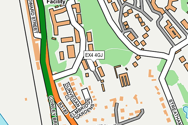
EX4 4GJ is located in the Duryard and St James electoral ward, within the local authority district of Exeter and the English Parliamentary constituency of Exeter. The Sub Integrated Care Board (ICB) Location is NHS Devon ICB - 15N and the police force is Devon & Cornwall. This postcode has been in use since September 2010.


GetTheData
Source: OS OpenMap – Local (Ordnance Survey)
Source: OS VectorMap District (Ordnance Survey)
Licence: Open Government Licence (requires attribution)
| Easting | 291280 |
| Northing | 94025 |
| Latitude | 50.735630 |
| Longitude | -3.542007 |
GetTheData
Source: Open Postcode Geo
Licence: Open Government Licence
| Country | England |
| Postcode District | EX4 |
➜ See where EX4 is on a map ➜ Where is Exeter? | |
GetTheData
Source: Land Registry Price Paid Data
Licence: Open Government Licence
Elevation or altitude of EX4 4GJ as distance above sea level:
| Metres | Feet | |
|---|---|---|
| Elevation | 30m | 98ft |
Elevation is measured from the approximate centre of the postcode, to the nearest point on an OS contour line from OS Terrain 50, which has contour spacing of ten vertical metres.
➜ How high above sea level am I? Find the elevation of your current position using your device's GPS.
GetTheData
Source: Open Postcode Elevation
Licence: Open Government Licence
| Ward | Duryard And St James |
| Constituency | Exeter |
GetTheData
Source: ONS Postcode Database
Licence: Open Government Licence
| Birks Grange (New North Road) | Duryard | 150m |
| Birks Grange (New North Road) | Duryard | 156m |
| King Edward Studios (Cowley Bridge Road) | St Davids | 170m |
| Red Cow Village (Cowley Bridge Road) | St Davids | 187m |
| Kilbarran Rise (New North Road) | St Davids | 227m |
| Exeter St Davids Station | 0.7km |
| Exeter Central Station | 1.2km |
| St James Park (Devon) Station | 1.5km |
GetTheData
Source: NaPTAN
Licence: Open Government Licence
| Percentage of properties with Next Generation Access | 100.0% |
| Percentage of properties with Superfast Broadband | 100.0% |
| Percentage of properties with Ultrafast Broadband | 0.0% |
| Percentage of properties with Full Fibre Broadband | 0.0% |
Superfast Broadband is between 30Mbps and 300Mbps
Ultrafast Broadband is > 300Mbps
| Percentage of properties unable to receive 2Mbps | 0.0% |
| Percentage of properties unable to receive 5Mbps | 0.0% |
| Percentage of properties unable to receive 10Mbps | 0.0% |
| Percentage of properties unable to receive 30Mbps | 0.0% |
GetTheData
Source: Ofcom
Licence: Ofcom Terms of Use (requires attribution)
GetTheData
Source: ONS Postcode Database
Licence: Open Government Licence


➜ Get more ratings from the Food Standards Agency
GetTheData
Source: Food Standards Agency
Licence: FSA terms & conditions
| Last Collection | |||
|---|---|---|---|
| Location | Mon-Fri | Sat | Distance |
| Reed Hall | 19:00 | 12:30 | 238m |
| Streatham | 19:00 | 12:30 | 493m |
| Red Cow Post Office | 19:00 | 12:00 | 570m |
GetTheData
Source: Dracos
Licence: Creative Commons Attribution-ShareAlike
The below table lists the International Territorial Level (ITL) codes (formerly Nomenclature of Territorial Units for Statistics (NUTS) codes) and Local Administrative Units (LAU) codes for EX4 4GJ:
| ITL 1 Code | Name |
|---|---|
| TLK | South West (England) |
| ITL 2 Code | Name |
| TLK4 | Devon |
| ITL 3 Code | Name |
| TLK43 | Devon CC |
| LAU 1 Code | Name |
| E07000041 | Exeter |
GetTheData
Source: ONS Postcode Directory
Licence: Open Government Licence
The below table lists the Census Output Area (OA), Lower Layer Super Output Area (LSOA), and Middle Layer Super Output Area (MSOA) for EX4 4GJ:
| Code | Name | |
|---|---|---|
| OA | E00101132 | |
| LSOA | E01033233 | Exeter 001F |
| MSOA | E02004149 | Exeter 001 |
GetTheData
Source: ONS Postcode Directory
Licence: Open Government Licence
| EX4 4AF | Dunvegan Close | 109m |
| EX4 4AE | Elmbridge Gardens | 137m |
| EX4 4AB | Lodge Hill | 174m |
| EX4 4AD | New North Road | 188m |
| EX4 4QX | Clydesdale Road | 190m |
| EX4 4NX | Cowley Bridge Road | 226m |
| EX4 4AA | Kilbarran Rise | 249m |
| EX4 4NY | King Edward Street | 258m |
| EX4 4PD | Streatham Drive | 259m |
| EX4 4RW | Highcroft Court | 266m |
GetTheData
Source: Open Postcode Geo; Land Registry Price Paid Data
Licence: Open Government Licence