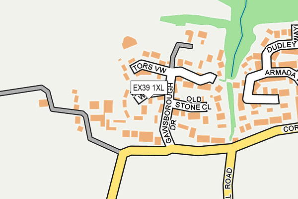
EX39 1XL lies on Rudyard Way in Westward Ho, Bideford. EX39 1XL is located in the Westward Ho! electoral ward, within the local authority district of Torridge and the English Parliamentary constituency of Torridge and West Devon. The Sub Integrated Care Board (ICB) Location is NHS Devon ICB - 15N and the police force is Devon & Cornwall. This postcode has been in use since June 1998.


GetTheData
Source: OS OpenMap – Local (Ordnance Survey)
Source: OS VectorMap District (Ordnance Survey)
Licence: Open Government Licence (requires attribution)
| Easting | 242518 |
| Northing | 128723 |
| Latitude | 51.036225 |
| Longitude | -4.247510 |
GetTheData
Source: Open Postcode Geo
Licence: Open Government Licence
| Street | Rudyard Way |
| Locality | Westward Ho |
| Town/City | Bideford |
| Country | England |
| Postcode District | EX39 |
➜ See where EX39 is on a map ➜ Where is Westward Ho!? | |
GetTheData
Source: Land Registry Price Paid Data
Licence: Open Government Licence
Elevation or altitude of EX39 1XL as distance above sea level:
| Metres | Feet | |
|---|---|---|
| Elevation | 80m | 262ft |
Elevation is measured from the approximate centre of the postcode, to the nearest point on an OS contour line from OS Terrain 50, which has contour spacing of ten vertical metres.
➜ How high above sea level am I? Find the elevation of your current position using your device's GPS.
GetTheData
Source: Open Postcode Elevation
Licence: Open Government Licence
| Ward | Westward Ho! |
| Constituency | Torridge And West Devon |
GetTheData
Source: ONS Postcode Database
Licence: Open Government Licence
| Gainsborough Drive (Cornborough Road) | Westward Ho! | 116m |
| Gainsborough Drive (Cornborough Road) | Westward Ho! | 122m |
| Francis Drive (Cornborough Road) | Westward Ho! | 581m |
| Francis Drive (Cornborough Road) | Westward Ho! | 583m |
| Nelson Road | Westward Ho! | 676m |
GetTheData
Source: NaPTAN
Licence: Open Government Licence
| Percentage of properties with Next Generation Access | 100.0% |
| Percentage of properties with Superfast Broadband | 100.0% |
| Percentage of properties with Ultrafast Broadband | 0.0% |
| Percentage of properties with Full Fibre Broadband | 0.0% |
Superfast Broadband is between 30Mbps and 300Mbps
Ultrafast Broadband is > 300Mbps
| Median download speed | 35.0Mbps |
| Average download speed | 35.5Mbps |
| Maximum download speed | 46.19Mbps |
| Median upload speed | 6.1Mbps |
| Average upload speed | 6.1Mbps |
| Maximum upload speed | 8.50Mbps |
| Percentage of properties unable to receive 2Mbps | 0.0% |
| Percentage of properties unable to receive 5Mbps | 0.0% |
| Percentage of properties unable to receive 10Mbps | 0.0% |
| Percentage of properties unable to receive 30Mbps | 0.0% |
GetTheData
Source: Ofcom
Licence: Ofcom Terms of Use (requires attribution)
Estimated total energy consumption in EX39 1XL by fuel type, 2015.
| Consumption (kWh) | 92,808 |
|---|---|
| Meter count | 10 |
| Mean (kWh/meter) | 9,281 |
| Median (kWh/meter) | 7,463 |
| Consumption (kWh) | 38,583 |
|---|---|
| Meter count | 10 |
| Mean (kWh/meter) | 3,858 |
| Median (kWh/meter) | 4,147 |
GetTheData
Source: Postcode level gas estimates: 2015 (experimental)
Source: Postcode level electricity estimates: 2015 (experimental)
Licence: Open Government Licence
GetTheData
Source: ONS Postcode Database
Licence: Open Government Licence


➜ Get more ratings from the Food Standards Agency
GetTheData
Source: Food Standards Agency
Licence: FSA terms & conditions
| Last Collection | |||
|---|---|---|---|
| Location | Mon-Fri | Sat | Distance |
| Bayview Road | 16:15 | 11:30 | 2,217m |
| Northam Post Office | 17:00 | 12:00 | 2,437m |
| J H Taylor Drive | 17:00 | 11:00 | 2,787m |
GetTheData
Source: Dracos
Licence: Creative Commons Attribution-ShareAlike
The below table lists the International Territorial Level (ITL) codes (formerly Nomenclature of Territorial Units for Statistics (NUTS) codes) and Local Administrative Units (LAU) codes for EX39 1XL:
| ITL 1 Code | Name |
|---|---|
| TLK | South West (England) |
| ITL 2 Code | Name |
| TLK4 | Devon |
| ITL 3 Code | Name |
| TLK43 | Devon CC |
| LAU 1 Code | Name |
| E07000046 | Torridge |
GetTheData
Source: ONS Postcode Directory
Licence: Open Government Licence
The below table lists the Census Output Area (OA), Lower Layer Super Output Area (LSOA), and Middle Layer Super Output Area (MSOA) for EX39 1XL:
| Code | Name | |
|---|---|---|
| OA | E00102892 | |
| LSOA | E01020310 | Torridge 002C |
| MSOA | E02004221 | Torridge 002 |
GetTheData
Source: ONS Postcode Directory
Licence: Open Government Licence
| EX39 1XQ | Gainsborough Drive | 81m |
| EX39 1XJ | Tors View | 91m |
| EX39 1XH | Old Stone Close | 102m |
| EX39 1XT | Pelican Close | 242m |
| EX39 1XB | Armada Way | 270m |
| EX39 1JS | Merley Road | 307m |
| EX39 1XD | Dudley Way | 332m |
| EX39 1XA | Drake Close | 368m |
| EX39 1JU | Merley Road | 403m |
| EX39 1XF | Blyth Court | 449m |
GetTheData
Source: Open Postcode Geo; Land Registry Price Paid Data
Licence: Open Government Licence