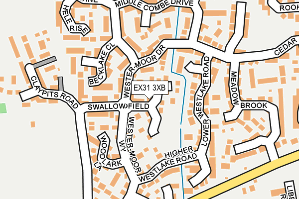
EX31 3XB lies on Swallow Field in Roundswell, Barnstaple. EX31 3XB is located in the Bickington electoral ward, within the local authority district of North Devon and the English Parliamentary constituency of North Devon. The Sub Integrated Care Board (ICB) Location is NHS Devon ICB - 15N and the police force is Devon & Cornwall. This postcode has been in use since July 1995.


GetTheData
Source: OS OpenMap – Local (Ordnance Survey)
Source: OS VectorMap District (Ordnance Survey)
Licence: Open Government Licence (requires attribution)
| Easting | 253383 |
| Northing | 131856 |
| Latitude | 51.067260 |
| Longitude | -4.093906 |
GetTheData
Source: Open Postcode Geo
Licence: Open Government Licence
| Street | Swallow Field |
| Locality | Roundswell |
| Town/City | Barnstaple |
| Country | England |
| Postcode District | EX31 |
➜ See where EX31 is on a map ➜ Where is Barnstaple? | |
GetTheData
Source: Land Registry Price Paid Data
Licence: Open Government Licence
Elevation or altitude of EX31 3XB as distance above sea level:
| Metres | Feet | |
|---|---|---|
| Elevation | 30m | 98ft |
Elevation is measured from the approximate centre of the postcode, to the nearest point on an OS contour line from OS Terrain 50, which has contour spacing of ten vertical metres.
➜ How high above sea level am I? Find the elevation of your current position using your device's GPS.
GetTheData
Source: Open Postcode Elevation
Licence: Open Government Licence
| Ward | Bickington |
| Constituency | North Devon |
GetTheData
Source: ONS Postcode Database
Licence: Open Government Licence
2001 1 NOV £78,000 |
1996 6 SEP £39,950 |
GetTheData
Source: HM Land Registry Price Paid Data
Licence: Contains HM Land Registry data © Crown copyright and database right 2025. This data is licensed under the Open Government Licence v3.0.
| Swallowfield (Wester-moor Way) | Roundswell | 62m |
| Westermoor Way | Roundswell | 241m |
| Meadow Brook (Old Bideford Road) | Roundswell | 258m |
| Woodside Court (Brannam Crescent) | Roundswell | 311m |
| Woodside Court (Brannam Crescent) | Roundswell | 329m |
| Barnstaple Station | 2.3km |
GetTheData
Source: NaPTAN
Licence: Open Government Licence
| Percentage of properties with Next Generation Access | 100.0% |
| Percentage of properties with Superfast Broadband | 100.0% |
| Percentage of properties with Ultrafast Broadband | 0.0% |
| Percentage of properties with Full Fibre Broadband | 0.0% |
Superfast Broadband is between 30Mbps and 300Mbps
Ultrafast Broadband is > 300Mbps
| Median download speed | 49.8Mbps |
| Average download speed | 46.7Mbps |
| Maximum download speed | 75.00Mbps |
| Median upload speed | 10.1Mbps |
| Average upload speed | 13.1Mbps |
| Maximum upload speed | 20.00Mbps |
| Percentage of properties unable to receive 2Mbps | 0.0% |
| Percentage of properties unable to receive 5Mbps | 0.0% |
| Percentage of properties unable to receive 10Mbps | 0.0% |
| Percentage of properties unable to receive 30Mbps | 0.0% |
GetTheData
Source: Ofcom
Licence: Ofcom Terms of Use (requires attribution)
Estimated total energy consumption in EX31 3XB by fuel type, 2015.
| Consumption (kWh) | 228,910 |
|---|---|
| Meter count | 30 |
| Mean (kWh/meter) | 7,630 |
| Median (kWh/meter) | 7,937 |
| Consumption (kWh) | 95,671 |
|---|---|
| Meter count | 30 |
| Mean (kWh/meter) | 3,189 |
| Median (kWh/meter) | 2,711 |
GetTheData
Source: Postcode level gas estimates: 2015 (experimental)
Source: Postcode level electricity estimates: 2015 (experimental)
Licence: Open Government Licence
GetTheData
Source: ONS Postcode Database
Licence: Open Government Licence


➜ Get more ratings from the Food Standards Agency
GetTheData
Source: Food Standards Agency
Licence: FSA terms & conditions
| Last Collection | |||
|---|---|---|---|
| Location | Mon-Fri | Sat | Distance |
| Brynsworthy Park | 18:00 | 12:30 | 553m |
| Maple Grove | 17:45 | 12:15 | 760m |
| Old Sticklepath Hill | 17:30 | 12:00 | 1,933m |
GetTheData
Source: Dracos
Licence: Creative Commons Attribution-ShareAlike
The below table lists the International Territorial Level (ITL) codes (formerly Nomenclature of Territorial Units for Statistics (NUTS) codes) and Local Administrative Units (LAU) codes for EX31 3XB:
| ITL 1 Code | Name |
|---|---|
| TLK | South West (England) |
| ITL 2 Code | Name |
| TLK4 | Devon |
| ITL 3 Code | Name |
| TLK43 | Devon CC |
| LAU 1 Code | Name |
| E07000043 | North Devon |
GetTheData
Source: ONS Postcode Directory
Licence: Open Government Licence
The below table lists the Census Output Area (OA), Lower Layer Super Output Area (LSOA), and Middle Layer Super Output Area (MSOA) for EX31 3XB:
| Code | Name | |
|---|---|---|
| OA | E00101702 | |
| LSOA | E01020085 | North Devon 012B |
| MSOA | E02004186 | North Devon 012 |
GetTheData
Source: ONS Postcode Directory
Licence: Open Government Licence
| EX31 3XT | Wester Moor Drive | 70m |
| EX31 3XQ | Wester Moor Way | 82m |
| EX31 3XF | The Coombes | 87m |
| EX31 3XU | Wester Moor Drive | 100m |
| EX31 3XR | Skylark Spinney | 101m |
| EX31 3XD | Swallow Field | 102m |
| EX31 3XN | Higher Westlake Road | 110m |
| EX31 3XE | Lower Westlake Road | 114m |
| EX31 3UZ | Becklake Close | 126m |
| EX31 3XL | Woodlark Lane | 142m |
GetTheData
Source: Open Postcode Geo; Land Registry Price Paid Data
Licence: Open Government Licence