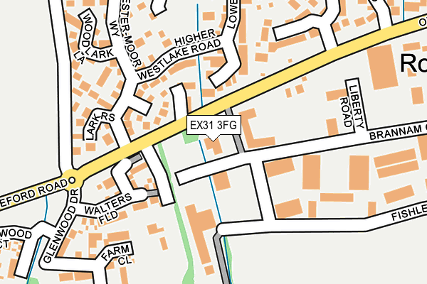
EX31 3FG is located in the Bickington electoral ward, within the local authority district of North Devon and the English Parliamentary constituency of North Devon. The Sub Integrated Care Board (ICB) Location is NHS Devon ICB - 15N and the police force is Devon & Cornwall. This postcode has been in use since May 2008.


GetTheData
Source: OS OpenMap – Local (Ordnance Survey)
Source: OS VectorMap District (Ordnance Survey)
Licence: Open Government Licence (requires attribution)
| Easting | 253468 |
| Northing | 131603 |
| Latitude | 51.065008 |
| Longitude | -4.092591 |
GetTheData
Source: Open Postcode Geo
Licence: Open Government Licence
| Country | England |
| Postcode District | EX31 |
➜ See where EX31 is on a map ➜ Where is Barnstaple? | |
GetTheData
Source: Land Registry Price Paid Data
Licence: Open Government Licence
Elevation or altitude of EX31 3FG as distance above sea level:
| Metres | Feet | |
|---|---|---|
| Elevation | 30m | 98ft |
Elevation is measured from the approximate centre of the postcode, to the nearest point on an OS contour line from OS Terrain 50, which has contour spacing of ten vertical metres.
➜ How high above sea level am I? Find the elevation of your current position using your device's GPS.
GetTheData
Source: Open Postcode Elevation
Licence: Open Government Licence
| Ward | Bickington |
| Constituency | North Devon |
GetTheData
Source: ONS Postcode Database
Licence: Open Government Licence
| Woodside Court (Brannam Crescent) | Roundswell | 73m |
| Woodside Court (Brannam Crescent) | Roundswell | 108m |
| Westermoor Way | Roundswell | 138m |
| Meadow Brook (Old Bideford Road) | Roundswell | 174m |
| Willow Tree Court (Brannam Crescent) | Roundswell | 232m |
| Barnstaple Station | 2.3km |
GetTheData
Source: NaPTAN
Licence: Open Government Licence
GetTheData
Source: ONS Postcode Database
Licence: Open Government Licence


➜ Get more ratings from the Food Standards Agency
GetTheData
Source: Food Standards Agency
Licence: FSA terms & conditions
| Last Collection | |||
|---|---|---|---|
| Location | Mon-Fri | Sat | Distance |
| Brynsworthy Park | 18:00 | 12:30 | 671m |
| Maple Grove | 17:45 | 12:15 | 734m |
| Old Sticklepath Hill | 17:30 | 12:00 | 1,960m |
GetTheData
Source: Dracos
Licence: Creative Commons Attribution-ShareAlike
The below table lists the International Territorial Level (ITL) codes (formerly Nomenclature of Territorial Units for Statistics (NUTS) codes) and Local Administrative Units (LAU) codes for EX31 3FG:
| ITL 1 Code | Name |
|---|---|
| TLK | South West (England) |
| ITL 2 Code | Name |
| TLK4 | Devon |
| ITL 3 Code | Name |
| TLK43 | Devon CC |
| LAU 1 Code | Name |
| E07000043 | North Devon |
GetTheData
Source: ONS Postcode Directory
Licence: Open Government Licence
The below table lists the Census Output Area (OA), Lower Layer Super Output Area (LSOA), and Middle Layer Super Output Area (MSOA) for EX31 3FG:
| Code | Name | |
|---|---|---|
| OA | E00101705 | |
| LSOA | E01020086 | North Devon 012C |
| MSOA | E02004186 | North Devon 012 |
GetTheData
Source: ONS Postcode Directory
Licence: Open Government Licence
| EX31 3FL | Brynsworthy Court | 72m |
| EX31 3XA | Wester Moor Close | 84m |
| EX31 3XS | Cross Meadows | 114m |
| EX31 3XW | Higher Westlake Road | 121m |
| EX31 3XH | Wester Moor Way | 128m |
| EX31 3XG | Wester Moor Way | 153m |
| EX31 3GE | Walters Field | 155m |
| EX31 3XN | Higher Westlake Road | 178m |
| EX31 3XR | Skylark Spinney | 179m |
| EX31 3XJ | Lark Rise | 185m |
GetTheData
Source: Open Postcode Geo; Land Registry Price Paid Data
Licence: Open Government Licence